Search

Mar 24, 2016

Conserving Inshore Juvenile Cod Habitat via HAPCs. Key government and academic guidance documents

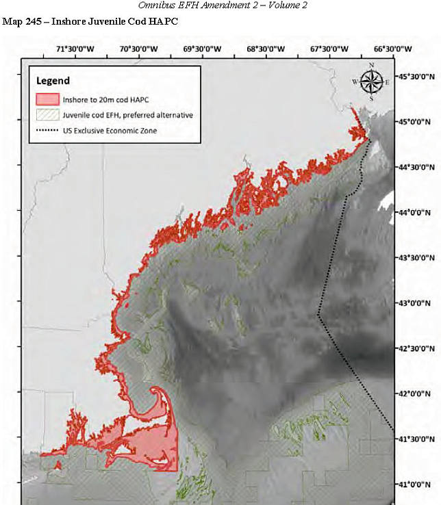
Habitat Area of Particular Concern, for Inshore Juvenile Atlantic Cod

Orange = Inshore juvenile cod HAPC.
Offshore coral canyon HAPCs not shown .
CONTENTS
1. Contacts
2. Summary: What's an HAPC?
3. What are Land based impacts to HAPCs?
4. Selection process
5. Maps of 2 alternatives for inshore juvenile cod HAPC. (MLW to 20 meters is Council's preference
6. Land-based impacts to inshore juvenile Atlantic Cod HAPC
7. Research and conservation of inshore juvenile atlantic cod habitat area of particular concern

1.  Contacts  
Michelle Bachman NEFMC fishery analyst   mbachman@nefmc.org   978/465-0492 ext 120


*  Andy Applegate NEFMC Ecosystem based fishery management   (978) 465-0492 (ext. 114)  email:  aapplegate@nefmc.org

* Ron Huber, Friends of Penobscot Bay  ron.huber@penbay.org 207-691-7485

2. What are  Habitat Areas of Particular Concern?
HAPCs are being delineated in the waters around the American coasts. New England Fishery Management Council-delineated HAPCs are  specific marine locations that fishermen, academics, the New England Fishery Management Council NEFMC, NOAA and NGOs come to agreement  as being  particularly essential habitats during some point in the lives of the finfish and shellfish species that commercial and recreational marine fisheries capture.

NEFMC's Description of HAPCs "The intent of the habitat areas of particular concern designation is to identify those areas that are known to be important to species which are in need of additional levels of protection from adverse impacts, "Designation of habitat areas of particular concern is intended to determine what areas within EFH should receive more of the Council's and NMFS' attention when providing comments on federal and state actions, and in establishing higher standards to protect and/or restore such habitat".  NOAA's definition of Habitat Ares of Particular Concern 

3. Land based impacts to HAPC. 
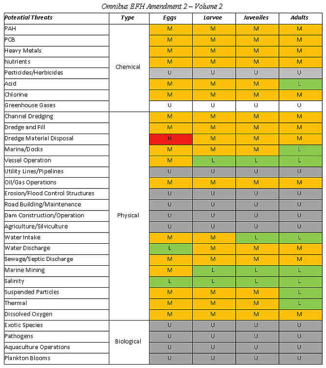
 NOAA Tech Memo Impacts to Marine Fisheries Habitat from Nonfishing Activities  in the Northeastern United States

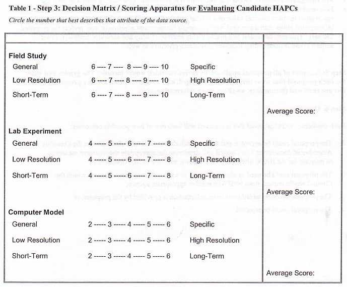
4. Selection Criteria  and decision matrix. To become listed as an HAPC the location must meet  a majority of these criteria. See Habitat
1a. Importance of Historic Ecological Function 
1b. Importance of Current  Ecological Function
2.  Sensitivity to Anthropogenic Stresses
3.  Extent of Current or Future Development Stresses
4.  Rarity of the Habitat Type

4. Delineator. The New England Fishery Management Council is responsible for identifying HAPCs in the waters from Rhode Island to the Canadian border, from the low tide shores to the entire American EEZ portion of the Gulf of Maine and Georges Bank, as well as the Nantucket Shoals south of Cape Cod 

Inshore Juvenile Atlantic Cod HAPC  
In 1999  NEFMC first concluded  that the shallow waters of New England meet all of the criteria except (4) Rarity of the habitat type. Evaluations since then have confirmed their earlier conclusions.  

The  Council found that the shallows of our New England coasts:
1a. Have well documented historic ecological functions for juvenile atlantic cod and their ecological partners,
1b. Have well documented  current ecological functions for juvenile atlantic cod and their ecological partners,
2. Are sensitive to anthropogenic stresses, such as  dredging, wastewater discharges, pesticide runoff
3. Are under stress from development, with more development pressures anticipated.
4. Are a common habitat type. Maine has more than 5,000 miles of shoreline, the amount within 65 feet of shore must be a large number of square miles

In 2004 the council prepared a review of the known habitat needs of inshore juvenile atlantic cod 
In 2006  the council  examined the inshore juvenile cod HAPC and looked at other  HAPC proposals aroudn the Gulf of Maine and Georges Bank (72pg pdf)
In 2013 the NEFMC DEIS on HAPCs refined its proposal for the Juvenile Atlantic Cod Habitat Area of Particular Concern 

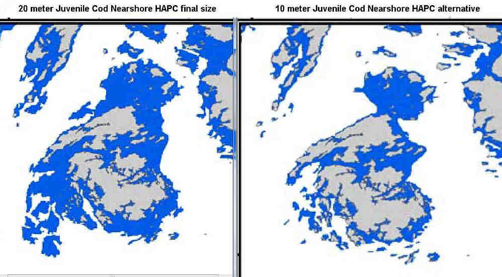
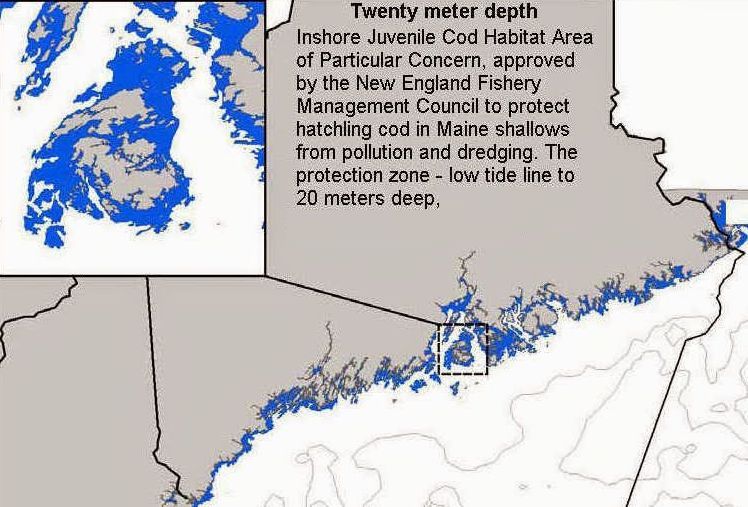
Alternatives: The Council set two alternatives. These are: mean low water to either the 10 meter  or 20 meter depth contour,. The Council's preferred alternative is the 20 meter depth contour alternative   

Note: Friends of Penobscot Bay supports the low water to 10 meter depth contour as most vulnerable to landbased impacts, as well as easy to delineate. FOPB feels that 20 meter depth contour covers habitats so much  less impacted as to be 

MAPS
New Eng inshore juvenile cod HAP Mean highwater to 20 meter depth contour

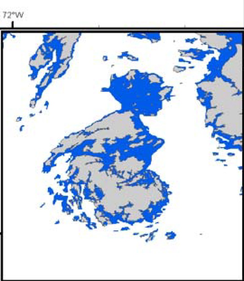
Alternative inshore juvenile cod HAPC map  0 to 10 meters    closeup of the ten meter alternative

Reports and research relevant to the inshore Juvenile Atlantic cod HAPC

* List of  landbased threats to inshore juvenile atlantic cod   Text version of list

* HAPC guidance on Human Activities that Impact Fish Habitat.- MidAtlantic Fishery Mgmt Council

* Impacts to Marine Fisheries Habitat from Non-fishing activities in the NE US

* Hatchling cod need soft microplankton for first food  GLOBEC 1998
 * Text version Scott M. Gallager, Jeff Van Keuren and Phillip Alatalo. Woods Hole Oceanographic Institute.1998

* Spatial Distribution of Ages 0 and 1 Atlantic Cod (Gadus morhua) off the Eastern Massachusetts Coast, 1978-1999, Relative to ‘Habitat Area of Special Concern’ (based on inshore trawl surveys)


* Proposal to Establish a Marine Sanctuary in Midcoast Maine. 1989. Part 1  Part Two


Mar 17, 2016

Big Gas 3/22/16. Rockland's latest draft of utility scale powerplant ordinance. Plus Index & Links

Rockland, Maine is lobster capitol of Maine. This small city on the western shore of  Penobscot Bay is in the throes of developing a powerplant ordinance geared toward  gasburning powerplants. Big Gas is having a big say in its contents. Please take a look at the March 22, 2016 draft  (below) and tell us what you think.  NOTE: Coming Event: March 24, 2016   Public review of latest version of the energy ordinances..

At issue: Gas dealmaker Energy Management Inc has been pushing a plan to build a fueled-by-tanker-truck gas power plant in Rockland. This would be follwed by  running gas pipelines  along the western shore of Penobscot Bay to Belfast.  Recent media coverage

March 22, 2016 version.
A. Index of  draft changes  below.  Existing Chapter 16 Site Plan Review  and Ch 19 Zoning and Planning 
B 3/22/16 Changes to Chapter 16 of Rockland Ordinance
C. 3/22/16 Changes to Chapter 19 of Rockland Ordinance


Earlier version:
February 23, 2016 version of draft utility powerplant ordinance changes

* 2/23/16 Changes to Chapter 16 of Rockland Ordinance Site review and planning    yellow=most recent edits, red=previous changes 

* 2/2316_Changes to Chapter 19 of Rockland Ordinances  (Performance standards)  
yellow=most recent edits, red=previous changes 

Fr left:Pro-gas Rockland city officials:city atty Beal. Mayor Ruf,
 city mgr Chaousis & City Councilor Clayton (facing away)

AUDIO 
* Hear the above two  draft documents discussed & further amended  at the 3/10/16  Rockland planning board meeting   Audio mp3s)


Mar 13, 2016

Governor's bill to prevent national monuments in Maine gets Ought NOT to Pass

In a  7 to 6 vote,  the state and local government committee gave an Ought Not To Pass to LD 1600

During the work session,   Maine AG's office explained that the federal supremacy clause supercedes the intent of the legislation.  The "Enclave Clause" of the US constitution  requires state consent to federal acquisition. State can "withhold its consent" to the federal acquisition obtaining the land. This will give the state  limited co-management of the property. But the state  couldn't do anything that violated  the federal purposes of managing that piece of land.

"Can't prevent the acquisition of the land nor frustrate what the federal government is trying to do there. "

http://www.mainelegislature.org/legis/bills/bills_127th/billtexts/HP109101.asp

Sec. 1. 1 MRSA §15  is amended to read:
§ 15. Consent of Legislature to acquisition of land by United States for public buildings; record of conveyances
In accordance with the Constitution of the United States, Article 1, Section VIII, Clause 17, and Acts of Congress in such cases provided, the consent of the Legislature is given to the acquisition by the United States, or under its authority, by purchase, condemnation or otherwise, of any land in this State required for the erection of lighthouses or for sites for customhouses, courthouses, post offices, arsenals or other public buildings, or for any other purposes of the government. Deeds and conveyances or title papers for the same shall must be recorded upon the land records of the county or registry district in which the land so conveyed may lie; and in like manner may be recorded a sufficient description by metes and bounds, courses and distances, of any tracts and legal divisions of any public lands belonging to the United States set apart by the general government for either of the purposes before mentioned, by an order, patent or other official paper so describing such land. These deeds and conveyances or title papers must contain a covenant requiring that all right, title and interest in the property revert to the grantor if the United States attempts to designate this property a national monument pursuant to 54 United States Code, Section 320301 (2015).

Mar 11, 2016

Rockland Planning Board AUDIO 3/10/16 energy ordinance development

MP3 audio of the 3/10/16  Rockland planning board discussion of its draft powerplant ordinance

Part 1  34min  *  Part 2  19 min  *  Part 3  20  min * Part 4  51min   *  Part 5 16min *   Part 6  4min

The board meeting included Larry Pritchett and Nathan Davis  repping the energy committee. It started as an informal discussion while waiting for tardy boardmembers to show up.  Then there was a public speaking opportunity that I used to urge the board to remember that they are not tasked to make the most industry friendly powerplant ordinance, but to make the most precautionary, most people protective and nature protective  ordinance possible.

Then came the ordinance  work

Mar 8, 2016

Maine Dredge Team March 7, 2016 meetings Audio mp3s of the interagency meeting

Monday March 7th, the Maine Interagency Dredge Team met in Augusta. 
Listen to audio from the event.

Intro of Dredge team 4min 19sec |

Part 1 21 min |

Part 2 22min |

Part 3. 16min

Participants were there to discuss dredging projects underway and under consideration. This included the Searport Harbor expansion dredge project, as well as other harbors along the Maine coast.
The public was represented by eco-attorney Kim Ervin Tucker of Lincolnville Beach, Becky Bartovics, Maine Sierra Club, North Haven Island, and Ron Huber, Friends of Penobscot Bay, Rockland.   The meeting allowed public participation by speakerphone 

The dredge team included: 
Pete Tischbein, Army Corp Craig Martin, navigation section, ACOE Wendy ____ Army Corp of Engineers planning John Chelley Chief of planning, f Army Corps Mark Habel Corps new eng, navigation Ed O'Donnel chief navigation section and the ONF program Dennis Nault Maine DMR Rob Elder MDOT trade office Maine DEP ____ Green Paul Mercer, commissioner DEP Mark Bergeron on MDEP Maine Geological Survey Maine Port Authority - Dredge committee Patty Aho, Sen Collins office staffer, Sen Collins for York County Pingree staffer Portland Senator Angus King staffer Tom Dobbins Portland harbor commission Jim Katz Saco coastal waters chief Patrick Fox Saco Payne, Normandeau Associates Biddeford harbor commission Wells harbormaster & town manager
Also attending: Maine Lobstering Union members (3) Kim Tucker Lawyer for Maine Lobstering Union David Black, Belfast Zone D lobsterman

ABOUT THE MEETING
The meeting was frustrating for critics of the Searport harbor dredge plan (aerial photo) . Dredging officials told Tucker at first that they had absolutely no new information about when the withdrawn Searsport harbor expansion dredge project might be reactivated. She managed to pull a few things out of them, like the identity of the till-now army corps officials in DC are who will decide when the Sarsport : Tab Brown, Army Corp Chief of Policy Regarding the Big Gas plan, the Corp's <Edward.G.O'Donnell@nae02.usace.army.mil>, told Huber that they have not received any communications at all about natural gas pipelines coming down from Massachusetts to the Penobscot Bay coast (with all the stream & river crossings required by such pipelines etc, the Corp will be involved. Huber also brought up the failing condition of the surface of the Rockland Breakwater, which has reduced pedestrian travel to the Rockland Breakwater Lighthouse. He said that the Rockland Harbor Commission was concerned that if they complained, the Corps might shut off pedestrian access entirely. Corp official Ed O'Donnell asked Huber to forward him some details.

The meeting was frustrating for opponents of the Army Corps of Engineers massive dredge plan for Searsport harbor:  It seemed that  try as they might, it was near impossible to get details from the army corps staff there on when the "withdrawn" application would become active again.   Federal officials claimed to have no information! Check out this exchange between Kim Ervin Tucker and an Army Corps official 
Q: What is the time frame you're talking about resurrecting this during the course of 2016?
A. We don't know.
Q: Who in DC specifically are you working with, what office?
A. Planning and Policy.
Q: A specific person there involved in that ?
A. Not a specific person, but  Tab Brown is the chief of that.
Q: Was there anything in particular you all are looking at?  Pockmarks? What specifically is now being re-evaluated for that project?
A.We don't know yet
Q: When will you know?
A: laughs
Q: Before the next team meeting? Will there be some activity taken before the next dredge team meeting?
AThe corps and DOT have to do a lot of talking, before the half stretch.
Q Thank you. 
----------------------------------------

 To get notified about  future  Maine  dredge meetings  write to  Todd Burrowes  at the Maine coastal program <Todd.Burrowes@maine.gov and ask him to put you on the list.   Burrowes is the Maine Coastal Program's "Federal Consistency Coordinator", meaning he's the contact when fed permit-requiring projects - including dredging but also  shoreline development like  riprapping  & piers-  come up. Coastal program phone: (207) 287-3200.

Feb 23, 2016

Owl hoot? Or...? Audio from 2/21/16 Owl Prowl in Rockport suggests attendees "missed" a quiet wild hooter.

Owl hoot?  Or what?    Audio recording from 2/21/16 Rockport owl prowl suggests 'jilted' attendees weren't listening closely enough.  Listen, and then ...You be the judge!

More than fifty owl enthusiasts led by two  staff of Merryspring Nature Center  walked through the muddy Rockport woods on Sunday evening. They  thought that they'd not heard a single wild owl hoot during the four listening stops of the sojourn.  

But listen below to an excerpt  of a recording from the first listening session. In between the 3rd & 4th call, it sounds like  an owl responding once in the distance, Was it?  The second audio features the "wild hoot" played at original speed and made louder and slowed down 
  
1. This 51 second recording starts with instructions to we listeners, then the owl call is played four times.(For brevity, I trimmed out most of the time listening between the instructions and when  the four owl calls began). Notice between the third and fourth call (at 42 seconds) you will hear the quet "real owl hoot" - at least it seems so to me.

2.   An 18 second recording of this "hoot" running at original speed and volume, then three increasingly higher volumes, then at its original, then slowed down to two different speeds and finally the original a last time.

What do you think?  It is two-syllabled as owl calls are.   Surely someone who knows their nightbirds will recognize that call.  If  someone would like the original unedited audio of the owl listening sessions, We'll make it available.

Feb 19, 2016

Virtually visit lobster homes in 3 Penobscot Bay harbors. Sunday March 6th Rockland

For Immediate release   2/19/16

Contact: Friends of Penobscot Bay  207-691-7485
Lobster-rich Penobscot Bay: Seeing is believing

ROCKLAND.  For more than a century, Penobscot Bay has been the salty heartland of the wild Maine lobster. On Sunday March 6th, from 2 to 4pm, join the Friends of Penobscot Bay at Stella Maris House in Rockland  as they inspect the lobster habitats of Rockland Harbor, Searsport Harbor and Rockport Harbor, using underwater videos they've made and acquired of the bayfloors of these places.

Since the 1840s Penobscot Bay has dominated New England's lobster fishery.   Come see lobsters hanging out beneath rocks and algae, sunken -into mud burrows, hiding hastily from an approaching video diver. Inspect the lobsters'   "prairie dog town"-style burrow communities
 
"West Penobscot Bay's lobster fishery alone brings in  around $130 million at the dock yearly", said Ron Huber executive director of Waterkeeper Alliance affiliate Friends of Penobscot Bay.   "There's an economic multiplier up to about 650 million dollars circulating within Penobscot bay  area communities.  Lobsters are our area's real renewable resource!"

The Friends of Penobscot Bay believe that keeping this fishery healthy requires keeping the watery homes of Penobscot Bay's lobsters - from the intertidal hideouts of juvenile lobsters to the bay's  sunken boulders and mudfloors.

"Seeing is believing" Friend's leader Huber said. "Come to Stella Maris House in Rockland  on  Sunday March 6th from 2-4pm and get to know the lobster habitats of Rockland Harbor, Searsport Harbor and Rockport Harbor" 

Stella Maris House is located at 148 Broadway, Rockland, adjacent to St Bernard's Catholic Church. Plenty of parking. Snacks will be served.

For more information, contact Friends of Penobscot Bay at  207-691-7485 or by email at coastwatch@gmail.com
 
Friends of Penobscot Bay: a Waterkeeper Alliance affiliate. Caring for Maine's biggest Bay

Jan 29, 2016

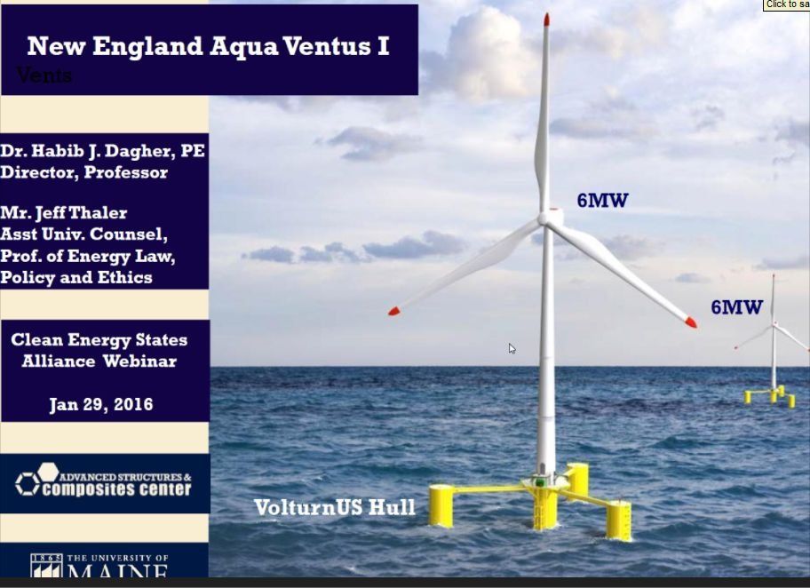
2016 Offshore Maine floating windpower 1/29/16 webinar. Audio & slides

Audio and slides from the 1/29/16 webinar presentation "Maine's Floating Offshore Wind Project: Moving Forward".

Speakers were Habib Dagher, Director, University of Maine's Advanced Structures and Composite Center, and  Jeff Thaler, Asst University Counsel and Maine AquaVentus Legal Counsel,

 The two cover the past, present and future of floating ocean wind turbines in the Gulf of Maine. Speakers refer to this slideshow

Habib Dagher
Introduction 3min37sec       

Habib Dagher  part 1  15 minutes

Habib Dagher part 2  14min55sec

Jeff Thaler 4 minutes

Habib Dagher Part 3 5 minutes

Q &A Part 1  6 minutes
Jeff Thaler

Q&A Part 2 to end of webinar 6 min 
UME's mini prototype in  Castine harbor storm


Jan 23, 2016

The great Long Cove spill of 1971


March 16, 1971  LONG COVE SPILL
From:  An Historical Review of Oil Spills Along the Maine Coast. 
Institute of the Gulf of Maine  May 14 1974

"Culminating years of minor spills presumed common to any fuel handling facility, the Long Cove spill at Searsport constitutes one of the outstanding examples of a chronic condition that has virtually eliminated a once normal and health clam community. 

A spill of volatile JP-5 (jet fuel) mixed with No. 2 fuel was discovered on March 16, 1971. Although initially reported by the U. S. Coast Guard to be "small and less  than a barrel" large quantities were found by DMR personnel flowing into tidal waters at Long Cove through a culvert and a  ditch.  By March 22 between 5,000 and 10,000 gallons had been recovered while oil covered the Little River flats some  five miles across Penobscot Bay. Aerial photographs of the slick progress were taken to show the rate of slick movement.

By March 26, the mortality area of clams in Long Cove increased from 1/3 of an acre to two acres.  During the same period sampling at Little River indicated 5 to 10 percent of the clams were dead. Only three days later, Long Cove mortalities covered 10 acres or 30 percent of the standing crop while the  Little River  area had risen to 50 percent mortalities.

Subsequently, the U. S. Air Force. owner of the oil terminal which pipes jet fuel to Limestone APB, contracted with theDepartment of Marine Resources to conduct a detailed study of the clam mortalities at Long Cove. This study estimated that the standing crop of soft clams was 23,000 bushels prior tothe spill. Sustained yield was estimated at 10,000 bushels.

By August, 1972, the reported mortality was 12,000 bushels. Oil was present in 23 percent of the 130 intertidal samples. All clams were unmarketable due to prolonged oil contamination. The Department of Marine Resources estimated that this condition may persist for many years.

As the market value of the clams in this area is estimated at $150,000 to the diggers annually on a sustained yield basis,the value of the standing crops is $345,000. Using an accepted EPA shellfish multiplier of retail value (Wong, 1969) the yearly crop would be worth as much as $4 million at 1973 values. Thus, there is a total loss of $4 million each year to the State of Maine based on the Department of Marine Resources files.

Analysis of the sediment samples at this location using gas chromotography indicates that the light fractions of oil work down into the sediments contaminating all forms of marine organisms. Also this analysis indicates that the spills have been continuing since the first spill in 1971. Unlike clams affected by sewage pollution which can be cleansed in as little as 48 hours, these clams are unsalvageable through any known techniques. Assessment of such damage to an entire community is extremely difficult since prior baseline studies rarely exist.

Histological studies of clams from Long Cove conducted by Paul Yevich of the Environmental Protection Agency for the Department of Marine Resources, showed an incidence of abnormal growths have been reported more recently in two other locations in the state where clams have been contaminated by oil. (Dow, personal communication)

According to the Director of Research at the Department of Marine Resources experiments conducted during 1973 with planting clams in both Long Is land and Long Cove and similar clam plants in uncontaminated areas show a marked increase in; mortalities in the two oil contaminated sites.


Jan 11, 2016

Rockland city FOAA's re big gas plan 2015 May June September and October 2015

Here are most of the FOAA'd documents relating to the plan to build a big gas power plant  and a big gas pipeline to feed it.  Request were for  "Meeting records, letters, faxes, emaits, attachments, phone notes, phone logs, photographs and other written and electronic records written, received or recorded by you from any source, between April 1, 2015 and May 11, 2015, inclusive, that pertain to Rockland Energy Center or its parent entity Energy Management, Inc. "


April and May 2015 FOAA  results for Rockland officials re gas plans 4/1/15 - 5/11/15


Jan 9, 2016

Penobscot Bay's historic oil spills: 1953-1972

An Historical Review of Oil Spills Along the Maine Coast
Excerpts


======================================


TABLE 2 - Total number of spills by Area/Number of Oil Terminals
                     (see Figure 6 for locations)

REA 5 ... Pemaquid to Owls Head                ................................. 2 spills from 2 terminals

         Waldoboro .............. 1
         Matinicus .............. 1

AREA 6.. .Owls Head to Camden                  ...................................14/9

         Rockland ............... 6
         Rockport ............... 1
         Vinalhaven ............. 2
         Camden ................. 5

AREA 7...Camden to North Penobscot - Searsport .................22/4

         Belfast ................ 3
         Islesboro .............. 1
         Castine ................ 2
         Searsport ..............16


AREA 8...Bucksport .....................................

          Bucksport   ..... .......... 9
          Frankfort   ........ ......1

AREA 9...Bangor to Old Town............................

          Bangor .................. .1
          Old Town ......... ....... 2

AREA 10. East Blue Hill Bay to Swans Is. - Bass Harbor.

          Stonington..............1l
          Swans Island ...... ....... 
          Brooksville ........ .....1

--------------------------------------------------------------

 APPENDIX A

           LIST OF OIL SPILLS 1953-1973 

0=Oil Spill Incident Data Sheet filled out -Appendix B

   DATE                  LOCATION                              SOURCE


TABLE 2 - Total number of spills by Area/Number of Oil Terminals
                     (see Figure 6 for locations)

REA 5 ... Pemaquid to Owls Head                ................................. 2/2

         Waldoboro .............. 1
         Matinicus .............. 1

AREA 6.. .Owls Head to Camden                  ...................................14/9

         Rockland ............... 6
         Rockport ............... 1
         Vinalhaven ............. 2
         Camden ................. 5

AREA 7...Camden to North Penobscot - Searsport .................22/4

         Belfast ................ 3
         Islesboro .............. 1
         Castine ................ 2
         Searsport ..............16


AREA 8...Bucksport .....................................

          Bucksport   ..... .......... 9
          Frankfort   ........ ......1

AREA 9...Bangor to Old Town............................

          Bangor .................. .1
          Old Town ......... ....... 2

AREA 10. East Blue Hill Bay to Swans Is. - Bass Harbor.

          Stonington..............1l
          Swans Island ...... ....... 
          Brooksville ........ .....1

--------------------------------------------------------------

 APPENDIX A

           LIST OF OIL SPILLS 1953-1973 

0=Oil Spill Incident Data Sheet filled out -Appendix B

   DATE                  LOCATION                              SOURCE


 JUN  21,t 1953        Stonington                         Pearlescence Plant
� JUN  23,s 1953       Searsport, CHs Sprague Co.         C.H. Sprague Fuel Depot

0 OCT  239 1953        Castine Harbor                      Maine maritime Academy ship

0 APR  8, 1954         Winter Harbor                       Unknown

* APR   5s, 1957       Stockton Springs; Searsport         'Northern Chemical Company

 MUG      1958         Belfast, Searsport ,.              Spragues, Dock
 'APR  199 1959        Belfast                             Maplewood Poultry CoMpAVY
 "SEP  30, 1961        Sears Island,, Stockton Springs     Jarka Dockst Searsport
*APR  129 1962        Sears Island, Stockton Springs      Jarka Docks,. Sow-sport
'*APR     1964         Fort Stockton                       Northern Chemical
 MAY   1, 1967         Rockland Harbor                    'Unknown
 FEB  18, 1968         Bucksport Harbor                    CoHa Sprague Company'

MAY   6, 1970         Searsport- Penobscot River           At pipeline J P-4           5,000 gals         Dumped by tank cleaning company            DEP

JUN   9, 1970         Bucksport-Penobscot River            St. Regis Paper Company

JUN  29, 1970         Castine Harbor                       Unknown
JUL  17, 1970         Bucksport; Penobscot                M/V PHIREMQN

AUG  21, 1970         Bucksport                           Tanker   E t

SEP  21, 1970         Bucksport                           Unknown
SEP  25, 1970         Bucksport                           Tanker TRADE DARLING

 OCT  14, 1970         Old Town    Unknown  #6       100 gallon         Unknown      DEP
OCT  16, 1970         Camden Harbor                         Unknown
DEC   8, 1970         Belfast                               Unknown

'JAN   79 1971          Hancock                              H.R. Joy Company

*MAR  16, 1971        Searsport                            Pipeline at USAF

 APR  21, 1971         Islesboro                            Mystery
JUN  28, 1971          Vinalhaven                           Oil terminal J.C. Calderwood ~~Gasoline             

AUG   39 1971          Bucksport                            Humble Oil Company
AUG  30, 1971         Searsport                             B&A docks
 SEP  20, 1971          Odum Ledge; Brooksville              Tanker FRANCIS So BUSHEY
 OCT   1, 1971         Rockport                             Truck
OCT  18, 1971         Searsport                            U.S0 Air Force Pipeline
OCT  28, 1971          Rockland Harbor                      Town sewer
DEC  16, 1971         Buckport                             St. Regis Paper Company

 JAN   2, 1972         Rockland Harbor                      Mystery (City sewer)


FEB  19, 1972          Matinicus                            Dock Diesel        50 gals        Storm broke dock lines            DEP

APR  17, 1972         Rockland.                            F�Jo O'Hara Company
� APR  24, 1972        Searsport                            Tanker OVERSEAS ADVENTURER
 MAY   9, 1972         Camden                               Mystery slick
MAY  22, 1972         Vinalhaven; Carvers Harbor           Unknown

 MAY  26, 1972         Old Town                             Penobscot Company
* MAY  31, 1972         Swans Island                         Oil terminal Mertic Morrison

JUN  16, 1972         Searsport                            Unknown
JULY  16, 1972         Searsport                            Unknown

JUL  25, 1972         Searsport                             Sunoco Garage
 JUL  25, 1972         Camden                                U.Se Post Office 
 JUL  27, 1972         Southwest Harbor                      Maine Maritime Academy SLOOP GEM!
AUG   8, 1972         Camden                                Mystery
SEP   59 1972         Bucksport                             St. Regis Paper Co.
SEP  12  1972          Rockland; Lermand Cove               Heating system of school    
 SEP  20, 1972         Searsport                             Tanker STOLT GEMINI

 SEP  28, 1972         Stockton Springs                      Unknown
 OCT  26  1972          Searsport (Morse Point)               Mystery spill

 NOV   4, 1972          Camden                               Harborside West Marina 


======================================================

TABLE 2 - Total number of spills by Area/Number of Oil Terminals
                     (see Figure 6 for locations)

REA 5 ... Pemaquid to Owls Head                ................................. 2/2

         Waldoboro .............. 1
         Matinicus .............. 1

AREA 6.. .Owls Head to Camden                  ...................................14/9

         Rockland ............... 6
         Rockport ............... 1
         Vinalhaven ............. 2
         Camden ................. 5

AREA 7...Camden to North Penobscot - Searsport .................22/4

         Belfast ................ 3
         Islesboro .............. 1
         Castine ................ 2
         Searsport ..............16


AREA 8...Bucksport .....................................

          Bucksport   ..... .......... 9
          Frankfort   ........ ......1

AREA 9...Bangor to Old Town............................

          Bangor .................. .1
          Old Town ......... ....... 2

AREA 10. East Blue Hill Bay to Swans Is. - Bass Harbor.

          Stonington..............1l
          Swans Island ...... ....... 
          Brooksville ........ .....1

--------------------------------------------------------------

 APPENDIX A

           LIST OF OIL SPILLS 1953-1973 

0=Oil Spill Incident Data Sheet filled out -Appendix B

   DATE                  LOCATION                              SOURCE


 JUN  21,t 1953        Stonington                         Pearlescence Plant
� JUN  23,s 1953       Searsport, CHs Sprague Co.         C.H. Sprague Fuel Depot

0 OCT  239 1953        Castine Harbor                      Maine maritime Academy ship

0 APR  8, 1954         Winter Harbor                       Unknown

* APR   5s, 1957       Stockton Springs; Searsport         'Northern Chemical Company

 MUG      1958         Belfast, Searsport ,.              Spragues, Dock
 'APR  199 1959        Belfast                             Maplewood Poultry CoMpAVY
 "SEP  30, 1961        Sears Island,, Stockton Springs     Jarka Dockst Searsport
*APR  129 1962        Sears Island, Stockton Springs      Jarka Docks,. Sow-sport
'*APR     1964         Fort Stockton                       Northern Chemical
 MAY   1, 1967         Rockland Harbor                    'Unknown
 FEB  18, 1968         Bucksport Harbor                    CoHa Sprague Company'


                                       32-


MAY   6, 1970         Searsport- Penobscot River           At pipeline J P-4           5,000 gals         Dumped by tank cleaning company            DEP

JUN   9, 1970         Bucksport-Penobscot River            St. Regis Paper Company

JUN  29, 1970         Castine Harbor                       Unknown
JUL  17, 1970         Bucksport; Penobscot                M/V PHIREMQN

AUG  21, 1970         Bucksport                           Tanker   E t

SEP  21, 1970         Bucksport                           Unknown
SEP  25, 1970         Bucksport                           Tanker TRADE DARLING


 OCT  14, 1970         Old Town    Unknown  #6       100 gallon         Unknown      DEP
OCT  16, 1970         Camden Harbor                         Unknown
DEC   8, 1970         Belfast                               Unknown

'JAN   79 1971          Hancock                              H.R. Joy Company

*MAR  16, 1971        Searsport                            Pipeline at USAF

 APR  21, 1971         Islesboro                            Mystery
JUN  28, 1971          Vinalhaven                           Oil terminal J.C. Calderwood ~~Gasoline             

AUG   39 1971          Bucksport                            Humble Oil Company
AUG  30, 1971         Searsport                             B&A docks
 SEP  20, 1971          Odum Ledge; Brooksville              Tanker FRANCIS So BUSHEY
 OCT   1, 1971         Rockport                             Truck
OCT  18, 1971         Searsport                            U.S0 Air Force Pipeline
OCT  28, 1971          Rockland Harbor                      Town sewer
DEC  16, 1971         Buckport                             St. Regis Paper Company

 JAN   2, 1972         Rockland Harbor                      Mystery (City sewer)


FEB  19, 1972          Matinicus                            Dock Diesel        50 gals        Storm broke dock lines            DEP

APR  17, 1972         Rockland.                            F�Jo O'Hara Company
� APR  24, 1972        Searsport                            Tanker OVERSEAS ADVENTURER
 MAY   9, 1972         Camden                               Mystery slick
MAY  22, 1972         Vinalhaven; Carvers Harbor           Unknown

 MAY  26, 1972         Old Town                             Penobscot Company
* MAY  31, 1972         Swans Island                         Oil terminal Mertic Morrison

JUN  16, 1972         Searsport                            Unknown
JULY  16, 1972         Searsport                            Unknown

JUL  25, 1972         Searsport                             Sunoco Garage
 JUL  25, 1972         Camden                                U.Se Post Office 
 JUL  27, 1972         Southwest Harbor                      Maine Maritime Academy SLOOP GEM!
AUG   8, 1972         Camden                                Mystery
SEP   59 1972         Bucksport                             St. Regis Paper Co.
SEP  12  1972          Rockland; Lermand Cove               Heating system of school    
 SEP  20, 1972         Searsport                             Tanker STOLT GEMINI

 SEP  28, 1972         Stockton Springs                      Unknown
 OCT  26  1972          Searsport (Morse Point)               Mystery spill

 NOV   4, 1972          Camden                               Harborside West Marina 


                                       32-