Search

Showing posts with label atlantic cod. Show all posts

Mar 24, 2016

Conserving Inshore Juvenile Cod Habitat via HAPCs. Key government and academic guidance documents

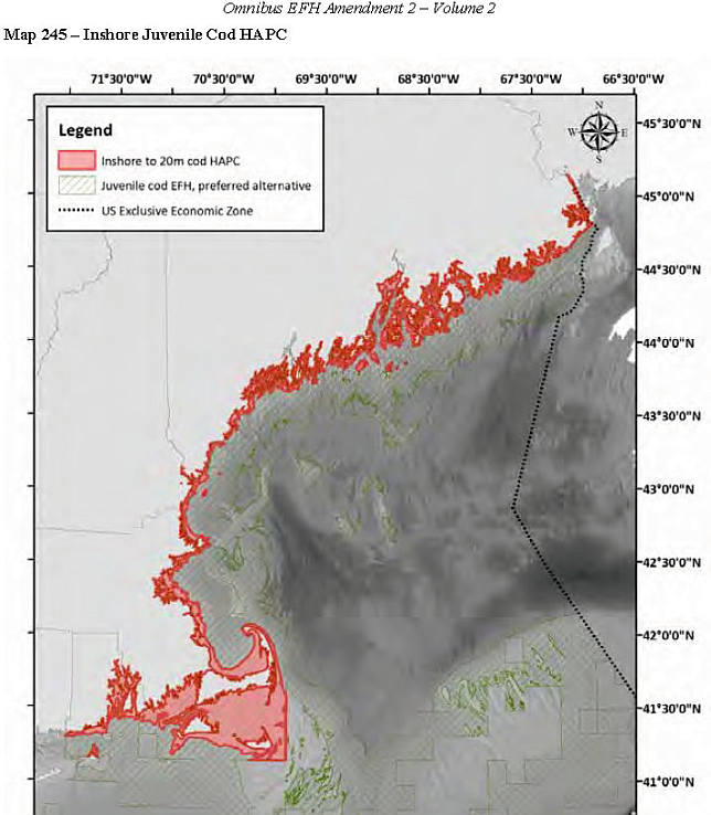
Habitat Area of Particular Concern, for Inshore Juvenile Atlantic Cod

Orange = Inshore juvenile cod HAPC.
Offshore coral canyon HAPCs not shown .
CONTENTS
1. Contacts
2. Summary: What's an HAPC?
3. What are Land based impacts to HAPCs?
4. Selection process
5. Maps of 2 alternatives for inshore juvenile cod HAPC. (MLW to 20 meters is Council's preference
6. Land-based impacts to inshore juvenile Atlantic Cod HAPC
7. Research and conservation of inshore juvenile atlantic cod habitat area of particular concern

1.  Contacts  
Michelle Bachman NEFMC fishery analyst   mbachman@nefmc.org   978/465-0492 ext 120


*  Andy Applegate NEFMC Ecosystem based fishery management   (978) 465-0492 (ext. 114)  email:  aapplegate@nefmc.org

* Ron Huber, Friends of Penobscot Bay  ron.huber@penbay.org 207-691-7485

2. What are  Habitat Areas of Particular Concern?
HAPCs are being delineated in the waters around the American coasts. New England Fishery Management Council-delineated HAPCs are  specific marine locations that fishermen, academics, the New England Fishery Management Council NEFMC, NOAA and NGOs come to agreement  as being  particularly essential habitats during some point in the lives of the finfish and shellfish species that commercial and recreational marine fisheries capture.

NEFMC's Description of HAPCs "The intent of the habitat areas of particular concern designation is to identify those areas that are known to be important to species which are in need of additional levels of protection from adverse impacts, "Designation of habitat areas of particular concern is intended to determine what areas within EFH should receive more of the Council's and NMFS' attention when providing comments on federal and state actions, and in establishing higher standards to protect and/or restore such habitat".  NOAA's definition of Habitat Ares of Particular Concern 

3. Land based impacts to HAPC. 
 NOAA Tech Memo Impacts to Marine Fisheries Habitat from Nonfishing Activities  in the Northeastern United States

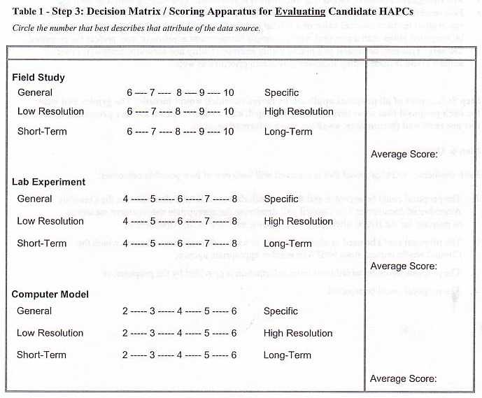
4. Selection Criteria  and decision matrix. To become listed as an HAPC the location must meet  a majority of these criteria. See Habitat
1a. Importance of Historic Ecological Function 
1b. Importance of Current  Ecological Function
2.  Sensitivity to Anthropogenic Stresses
3.  Extent of Current or Future Development Stresses
4.  Rarity of the Habitat Type

4. Delineator. The New England Fishery Management Council is responsible for identifying HAPCs in the waters from Rhode Island to the Canadian border, from the low tide shores to the entire American EEZ portion of the Gulf of Maine and Georges Bank, as well as the Nantucket Shoals south of Cape Cod 

Inshore Juvenile Atlantic Cod HAPC  
In 1999  NEFMC first concluded  that the shallow waters of New England meet all of the criteria except (4) Rarity of the habitat type. Evaluations since then have confirmed their earlier conclusions.  

The  Council found that the shallows of our New England coasts:
1a. Have well documented historic ecological functions for juvenile atlantic cod and their ecological partners,
1b. Have well documented  current ecological functions for juvenile atlantic cod and their ecological partners,
2. Are sensitive to anthropogenic stresses, such as  dredging, wastewater discharges, pesticide runoff
3. Are under stress from development, with more development pressures anticipated.
4. Are a common habitat type. Maine has more than 5,000 miles of shoreline, the amount within 65 feet of shore must be a large number of square miles

In 2004 the council prepared a review of the known habitat needs of inshore juvenile atlantic cod 
In 2006  the council  examined the inshore juvenile cod HAPC and looked at other  HAPC proposals aroudn the Gulf of Maine and Georges Bank (72pg pdf)
In 2013 the NEFMC DEIS on HAPCs refined its proposal for the Juvenile Atlantic Cod Habitat Area of Particular Concern 

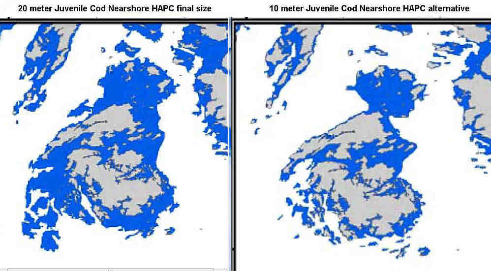
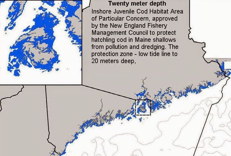
Alternatives: The Council set two alternatives. These are: mean low water to either the 10 meter  or 20 meter depth contour,. The Council's preferred alternative is the 20 meter depth contour alternative   

Note: Friends of Penobscot Bay supports the low water to 10 meter depth contour as most vulnerable to landbased impacts, as well as easy to delineate. FOPB feels that 20 meter depth contour covers habitats so much  less impacted as to be 

MAPS
New Eng inshore juvenile cod HAP Mean highwater to 20 meter depth contour

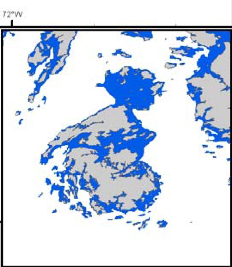
Alternative inshore juvenile cod HAPC map  0 to 10 meters    closeup of the ten meter alternative

Reports and research relevant to the inshore Juvenile Atlantic cod HAPC

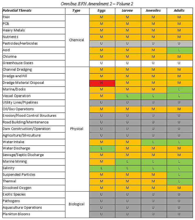
* List of  landbased threats to inshore juvenile atlantic cod   Text version of list

* HAPC guidance on Human Activities that Impact Fish Habitat.- MidAtlantic Fishery Mgmt Council

* Impacts to Marine Fisheries Habitat from Non-fishing activities in the NE US

* Hatchling cod need soft microplankton for first food  GLOBEC 1998
 * Text version Scott M. Gallager, Jeff Van Keuren and Phillip Alatalo. Woods Hole Oceanographic Institute.1998

* Spatial Distribution of Ages 0 and 1 Atlantic Cod (Gadus morhua) off the Eastern Massachusetts Coast, 1978-1999, Relative to ‘Habitat Area of Special Concern’ (based on inshore trawl surveys)


* Proposal to Establish a Marine Sanctuary in Midcoast Maine. 1989. Part 1  Part Two


Sep 15, 2009

Sears Island at the Alamo! Pt 1 & 2

T'was a fine time at the Alamo Theater in Bucksport last night. The Great Game playing out once more.
Both hours roared by; I couldn't believe it when it was noted but a few minutes remained...See photos here.

Here  are my recollections of the first hour: The entryway, where Sally Jones displayed used cores of  rhyolite, which a first nations-er  discarded on the island sometime during the last fifty centuries of the managing of Sears island 's natural resources by the Wabanaki and the red paint Maritime Archaic peoples. She issued Won't clam up! pins and en-coffined mourning-the-island visors to those entering the theater. And held forth to Tanya Mitchell,  reporter from the Belfast newspaper.

Then off  to the cavernous interior, where, on the long table on the raised stage where the five forumistas would sit sat,  two water cups (speaking is thirsty work!) flanked each talker's table microphone.

A biot of sound checkery, and an introduction by Amy Brown. Then an explanation of the forum's process byWERU moderator Gray Parrot: Five minutes for each panelist to lay out their main points, then one question of another panelist by each panelist, then a question by the moderator for all the panelists to answer, then questions from the audience until the end.

Damon started off. He acknowledged multiple valid sides to the controversy, admitted that initially he and his committee had voted unanimously to condition the granting of the easement to a port wannabe  first acquiring port permits. Baldacci convinced him to redo the vote, getting around Public Law 277  by having the Transportation Committee merely assent to a gubernatorial executive order accepting the conservation easement, and not assenting directly  to MDOT's split the island plan; [ Aside: this bit of legerdemain, by the way,angered some of the veteran committee members who were being asked to now vote  unanimously AGAINST what they'd just voted  unanimously FOR, amid heartily confused new legislators in the Transportation committee who complained they were being forced to vote in a rush, on the day this Sears Island thing  landed in their laps, without rknowing hardly any details - and all because Damon had scheduled a bus trip to a fish hatchery for that afternoon!  On little fish, this island's fate keeps pivoting.

In any case, Senator Damon said, the division of Sears Island for port and protected areas was the right thing.

Peter Taber was next He noted his 18 years of journalism in  Waldo County; and his close following of,  and reportage on, Sears Island development schemes by governor's Mckernan, King and Baldacci in his first term.  He detailed at length the overall dishonesty and rigging of the process by each succeeding chief executive's government , the legislature and us congress, industry and NGO's alike.

Jim Freeman followed. He noted his 25 years in Maine, his 15 years of activism around defense of Sears island. He agreed Sears Island was "an incredible place", extolled its fish nursery, noted he'd been involved in protecting ii in the 90's and early '00's, but , fearing the state might sell the island to condominium development, decided that saving part of it by the state giving  MCHT a conservation easement over the east side was better than nothing. And besides there might never be a port on the other side since Mack Point across the bay isn't filled to capacity. Thus he joined the MDOT's Sears Island  Joint Use Planning Committee and went with their flow.

David Cole of Maine DOT described the state's plan for a "trans-shipment" container port, one that could send double stacked containers by rail  from ships docking at Sears Island to depots in the midwestern US  by way of Montreal.  Rail is the "most environmentally friendly"  of all transportation modes anyway, he noted. One-third the carbon footprint.

I was next. I noted that  a "trans-shipment container port" meant that it would not carry Maine-bound goods; those would all continue to come into and around the state by truck or other ports. The transhipment rail line would take  the containers  form the ship and directly through and out of Maine unopened. I also noted that a containerport  is a heavy air polluter: the ships, trains, trucks and cranes all running their petrol-burning engines at once all the time. The upper bay would become an asthma cluster zone in epidemiological studies.  I noted that the island was set up at the interface between river and bay and its location was perfect for growing baby groundfish and other fishes (although the illegally created causeway's lack of culverts has diminished that function and must be pierced).

Then came questions from panelist to panelist:
Damon asked Peter why he was accusative, "inflammatory". Why do you choose to discredit?   Peter replied with a detailed description of the perfidy perpetuated by Cole's agency and by Sierra Club, from SIPI's beginnings to the present. Damon said that the sell-out NGOs reserve the ability to question why 2/3 of the island was conserved.He's not convinced they are all on board. (Cole looked right uncomfortable hearing this this, as he did when Freeman next to him announced his lukewarm support of a port on the island.

Peter asked Damon to explain why he had earlier said that he was not sure of the sincerity of the people that signed onto the agreement; did he still feel that way.

Jim Freeman noted that he and I had worked together for years on  Sears Island. Why, he asked, was I (RH)  "on the outside"  casting  "wild allegations", and not on the inside being a part of JUPC?   I replied that at the startup of the JUPC process I was busy suing Dragon Cement in Thomaston to make them cap their dusty CKD mound; when I saw the Sierra Club and Earth First!er Jim Freeman were on the Sears Island  Joint Use Committee, I thought  the island was safe - these people have never compromised when it came to protecting the entire island from development.

What a shoc, I said,  to find out it wasn't so!  Freeman and Sierra Club had consensed with MDOT against piercing the causeway! Had agreed a port was an "appropriate use" of western Sears Island agreed to triple the amount of acreage given up to industrial development.   And how sad that Mr Freeman  and the Sierra Club would not respond to the public whose interests they were supposedly representing, would not meet with them, would only assure them that everything was fine.

Coleasked his question next.  He claimed overwhelming support for island splitting plan by mainstream enviro groups, by the community of Searsport, by the legislature, by Downeast Magazine, etc, then asked Peter if he would concede that he was maybe "a little out of touch"?

Peter conceded no such thing! and pointed out how the state's process had been manipulated.  How assent for the port plan was either manufactured by MDOT's facilitator eliminating island protectors from the SIPI, or by  officials representing the town of Searsport claiming town support without polling its citizens, by Sierra club, the new version,  likewise not consulting its members before a few leaders gave support ot island splitting. By Senator Damon rushing the governor's/MDOT's plan throughout a bewildered Transportation Committee while keeping it entirely out of the Marine Resources Committee. No real support. Only the appearance of it.

I asked Commissioner Cole why Maine DOT was not going by the requirements of the Maine Sensible Transportation Policy Act (after first describing it and its relevance to the Sears Island planning process) Cole replied that since the matter was under litigation ( by me and two other Mainers) he was not going to answer!  But, he continued, "We don't even have a development yet, let alone a design, let alone a permitting process.  I can assure you that when a port is considered, if and when, that there be extensive public process. All applicable federal and state rules and laws  will be followed." (quote from recording).

End of Part One of my recollections of the meeting. Recordings of the speakers,and the rest of the two hour forum coming up soon. Somewhere in there Cole agrees to hold a hearing in  the marineresrouces committee about Sears Island.

Sears Island Forum yields promise by Senator Damon to convene hearing on fishery impacts,

Bucksport.  At a forum last night  on the future of Sears Island, Senator Dennis Damon (D-Trenton) co-chair of the Maine Legislature's Marine Resources Committee, said if plans for a container port  advance, he will order a hearing on the fish habitat surrounding the upper Penobscot Bay island..

His announcement came after a succession of opponents of a proposed container port plan for the Sears Island near the mouth of Penobscot River  criticised MaineDOT and the Legislature for ignoring the threat a port on the island would pose to the  well-documented groundfish nursery shoals edging the island's west side. The so called Wasumkeag Shoal is brackish and rich with eelgrass and  supplies young cod pollock, haddock and other fish to the greater bay. The shoal would have to be partly dredged away to make room for an industrial port. The need to protect that marine habitat stymied efforts by former Governor Angus King to build a port there.

"Its about time," said Ron Huber of Penobscot Bay Watch, a panelist at the forum, who spoke in defense of the fish nursery at the forum. "Killing off the habitat necessary for baby cod to survive in Penobscot Bay would hold back inshore groundfish recovery for decades. You don't attack the bay's maternity ward"

Damon said that he will convene the hearing  when and if a port plan for Sears Island is applied for. But Huber and other critics of thesears Island port&park plan warned that by waiting until then, would be too late to have an impact on the application process. They urged him to hold a hearing on the role of upper Penobscot Bay's habitat in producing  inshore groundfish as soon as possible, and create protections for it.


--

Sep 10, 2009

Will MDOTset off wild cannibal fish spree in Penobscot Bay?

17,000 to One!
Robert Gregory, director of the Centre of expertise for aquatic habitat research with Fisheries and Oceans, Canada (DFO) says that the removal of eel grass reduces the number of age zero cod by some 80 per cent. And Other Canadian cod researchers put it thus: "Research has concluded the [eelgrass] habitat is an effective refuge from predators, where the 90-day survival rate of juvenile cod in eel grass compared to coarse/barren bottom was 17,000 to 1."

17,000 to One!

For Maine's transportation secretary David Cole , for State Senator Dennis Damon, both of whom surely know better, in company with Sierra Club (Maine Chapter) leaders, to be comfortable with a project that would take away Penobscot Bay's eelgrass and would degrade many acres more....Uh uh!

The wiliest most successful predator of age zero cod - those just out of the egg - are other cod, those a year and more older. Juvenile cod are habitat-limited populations, when insufficient weedy refuge exists for age zero codfish, still clutching their yolk sacs, to hide , they succumb to their hungry elders.

Baldacci's consensus pact w/ MCHT, Sierra Club and the shipping industries would allow mitigation off site , replacement of Sears Island's eelgrass meadows and shoals by wetlands protection or creation elsewhere. . Basically allow payment of a wergild to compensate for killing the nursery shoals off Sears Island. Taking out the eelgrass and kelp mud and cobble habitat structure to pave the way for a container port would set cannibal fish loose in Wasumkeag's maternity ward! Shan't happen!

Jan 22, 2009

Baldacci, Cole okay dismembering Sears Island; activists vow to contest final rule.

Opponents of a Maine DOT-devised plan to partition Penobscot Bay's Sears Island into a port zone and a protected zone said that they will contest today's approval of a controversial conservation easement by the Baldacci Administration.

Because the easement is a Final Agency Rule, those seeking to overturn the rule have thirty days to bring suit before state or federal court.

"Sears Island will not be dismembered," said Ron Huber, executive director of Penobscot Bay Watch. "The final rule is based on false and misleading information, purposely fed to both MDOT's Sears Island Joint Use Planning Committee, and to the members of the Legislature's Transportation Committee*. Garbage in/garbage out. It won't hold up to judicial scrutiny."

* Under Public Law 277 the Maine Legislature's Joint Committee on Transportation has authority to review all Sears Island development proposals. After the committee reviewed the Joint Use Plan on November 18, 2008 and in December, Transportation Committee co-chair Dennis Damon who had promised on June 26, '08 to bring the Sears Island issue before the legislature's Marine Resources Committee, declined to do so.
Instead, brushing aside concerns from new legislators on the Transportation Committee, and refusing to allow Sears Island fishery concerns to be brought up before the Marine Resources Committee on January 14th (the Senator co-chairs that committee, too) , Damon shoved approval of the Joint Use Plan (15 minute mp3) through on January 15, 2009: in the process dealing a tremendous slap in the face to Midcoast groundfishermen struggling to keep their industry alive in the current ecomoic climate.
Huber said his group and others have worked with many others to restore Penobscot Bay's finfisheries and shellfisheries.

"The chronic pollution and permanent destruction of groundfish nursery habitat and salmon habitat in the upper bay that a container port on Sears Island would make it far less likely that the bay's cod, haddock and flounder will make a comback in our lifetime.

In addition, 'smolts', young Atlantic salmon transitioning from freshwater to saltwater life, gather in the shallow brackish protected waters near Sears Island while they morph from being fresh to saltwater breathing. These too will find their essential nearshore habitat destroyed or fouled with ballast water, bilge and other tainted runoff from a functioning container port. The same holds true for Penobscot River's sturgeon

The groups will ask that the MDOT's Final Order partitioning the island into conservation zone and port zone be set aside, and that Maine DOT be made to carry out and pass an environmental review as required under federal and state law before moving ahead with any partition plan

Penobscot Bay Watch is part of a larger regional coalition, Fair Play for Sears Island, which will take part in the expected litigation. "This is not the first time we've fought off a Sears Island proposal, said Harlan McLaughlan, director of Fair Play for Sears Island, "but we hope it will be the last."

At issue is whether Maine DOT and its Joint Use Planning Committee (JUPC) erred when they declined during their two years of deliberations to consider the environmental damage a container port might have on the island's and bay's natural marine resources. The agency claimed its JUPC group, which operated as a state rulemaking consensus process could voluntarily exempt itself from having to consider the potential environmental impacts of their evolving plan.

Critics say this contravenes the Sensible Transportation Policy Act (STPA), Maine's key transportation law. STPA warns that MDOT's decisions on transportation plans (like Sears Island) can: "have profound, long-lasting and sometimes detrimental impacts on the natural resources of the State, including its air quality, land and water."

Becuase of that concern, in its rules, STPA "requires that MaineDOT identify and develop strategies that are context sensitive and minimize adverse affects to environmental quality."

"Evidently Commissioner Cole forgot to look at his rulebook," Huber said. "Now we'll have to have a judge 'throw the book at him'.

Baldacci/Cole plan goes against Legal Precedent. The January 22 2009 decisions also run MDOT afoul of established federal Sears Island legal precedent. Consider the 1989 federal court case Sierra Club v. Marsh (pdf), 1989 US App (1st) 75 - a critical Sears island precedent case.

In his decision, then-1st Circuit Chief Judge Breyer wrote thusly about the folly of MDOT's planning process playing down the likely harm a port on Sears Island could have:
"..... the harm consists of the added risk to the environment that takes place when governmental decisionmakers make up their minds without having before them an analysis (with prior public comment) of the likely effects of their decision upon the environment."
Breyer held that decisions about Sears Island need to be made in
"...a process whereby administrators make important decisions with an informed awareness of how the decision might significantly affect the environment."

But Maine DOT and its Joint Use Planning Committee have done just the opposite. Wouldn't Judge Breyer - now a US Supreme Court justice - be disappointed to learn of Maine DOT's repeat of its 1980s blunder?

Huber said he is not surprised by the Baldacci Administration's machinations. "When it comes to Sears Island, Maine's government has a sad history of ignoring economic and ecological reality, and of skirting or outright ignoring the law." he said.

In 1995, facing certain denial of his cargo port plan for environmental reasons, Governor Angus King and members of the Maine congressional delegation infamously pressured EPA's regional administrator into agreeing to transfer the EPA's staff reviewing Sears Island off the Sears Island port plan review.

When he learned of King's plot, Huber notified legal advocacy organization Public Employees for Environmental Responsibility, which filed a lawsuit that forced the EPA administrator to reverse his decision and keep the staff on the job. Once the EPA official backed down, PEER withdrew its suit, the staffer returned to work and, based on her recommendations, the US Army Corp of Engineers set stiff requirements for mitigating the damage the port would cause to island and bay. Unable to foot the bill, Angus King withdrew his Sears Island port plan in early 1996. (short mp3)

Huber said he was not surprised that Maine DOT didn't seek a review of their plan by the Maine Department of Marine Resources. "DMR kowtowed completely to the port proponents under King" he said.

In October 1995, then-DMR Commissioner Robin Alden submitted a controversial letter to the Army Corps of Engineers and FHWA that pooh-poohed the value of Sears Island's shoals and eelgrass meadows as fish habitat, earning her a rebuke from federal officials as well as New England's marine science community - including one of the scientists she quoted in her letter.

Steve Miller of the Islesboro Islands Trust wrote in a letter to Commissioner Alden that his "initial reaction ranged from disbelief to horror.. .your letter seemed more like a defense of the cargo port than a discussion of natural resources and their preservation."

Ironically, Miller is now himself committed to port development on Sears Island, as a consensing member of the Joint Use Planning Committee, a decision that has put him at odds with many former allies.

""We likewise reacted with disbelief and horror, when we learned that Steve Miller had joined the dark side", McLaughlan said. "Go figure."

Perhaps mindful of Alden's debacle, present day Marine Resources Commissioner George Lapointe has kept mum.

"Hopefully something will finally penetrate MDOT's leaders' thick skulls", said Mclaughlan. "Their brains always turn to mush when Sears Island gets put on their to-do list."


Below: Governor Baldacci's January 2 press release (includes full text of governor's executive order)

-----------------------------------------------------------------------------

January 22, 2009

An Order Implementing the Recommendations of the Sears Island Planning Initiative's Joint Use Planning Committee

WHEREAS, the State of Maine is dedicated to preserving its historic coastline while providing economic opportunities to its citizens that its proximity to navigable waters offer; and

WHEREAS, the State of Maine owns Sears Island in the Town of Searsport, County of Waldo, where both of these goals can be compatibly and responsibly pursued; and

WHEREAS, Sears Island lies centrally on Maine's largest bay, Penobscot Bay, which has seaports, manufacturing centers, farms, rocky headlands and well over 100 islands on its waters and shores. The Bay, which serves as the economic domain of a thousand or more working fishing and lobster boats, includes a major shipping channel, and is a recreational and ecological location of world class standing; and

WHEREAS, Sears Island located in the harbor of Searsport is uniquely suited, through its deep water ship access and its rail connection allowing double stacked rail cars to travel unabated from Searsport to Chicago, to be the location of a future freight container port; and

WHEREAS, Maine's future economy will be strengthened by the inclusion of Sears Island in the global freight transportation routes; and

WHEREAS, the parties to the Consensus Agreement, that created the Joint Use Planning Committee, shared a good faith belief that opportunities to pursue a port and conservation uses were compatible and should be given equal weight and attention and should all be vigorously pursued ; and

WHEREAS, the Sears Island Planning Initiative Consensus Agreement established that the appropriate uses for Sears Island are compatibly managed marine transportation, recreation, education, and conservation, therefore, the joint use planning process defined two significant land use parcels on the Island, a 601-acre conservation parcel known as the "Protected Property" and a 330-acre "Transportation Parcel", for the benefit of the Town of Searsport, County of Waldo and the State of Maine; and

WHEREAS, Sears Island Planning Initiative Consensus Agreement established that the Maine Department of Transportation (MaineDOT) will actively market, solicit proposals and create partnerships for a cargo/container port on Mack Point and/or Sears Island on the Transportation Parcel; and

WHEREAS, Sears Island Planning Initiative Consensus Agreement established that the MaineDOT, with the Town of Searsport and appropriate others will provide for light recreation, education and conservation facilities on the Protected Property by conveyance of an easement covering that area; and

WHEREAS, the Final Report and Recommendations for Implementation of the Sears Island Planning Initiative Joint Use Planning Committee, prepared pursuant to the Sears Island Planning Initiative Steering Committee Consensus Agreement has been presented to and approved by the Joint Standing Committee on Transportation of the Maine Legislature in accordance with Maine Public Law 2005, Chapter 277;

NOW, THEREFORE, I, John E. Baldacci, Governor of the State of Maine, do hereby order and direct as follows:

The Maine Department of Transportation will in all respects implement the recommendations of the Sears Island Planning Initiative's Joint Use Planning Committee.

o MaineDOT, as Grantor, will grant a Conservation Easement on a 601-acre conservation parcel known as the Protected Property on Sears Island to the Maine Coast Heritage Trust, the Holder, with the Maine Department of Environmental Protection as the Third Party Enforcer.

o MaineDOT will fix the boundaries of the Transportation Parcel and the Protected Property as determined by the Joint Use Planning Committee and defined in the Conservation Easement.

o The Transportation Parcel is reserved by MaineDOT for future transportation use, allowing for joint or concurrent development of a marine transportation facility, compliant with 23 CFR 774.

o MaineDOT will create a "Sears Island Conservation Area Advisory Group" to provide public input on future land use and guidance to MaineDOT with respect to the management of the Protected Property.

o MaineDOT, upon execution of the Conservation Easement, will actively and aggressively work with the Maine Port Authority and other interested parties to initiate the process of marketing and development of a cargo/container port on Mack Point and Sears Island in accordance with the Agreement including initiating a request for proposals for a cargo/container port facility which will utilize environmentally-responsible technologies to minimize impact to natural resources, cultural values and existing marine activities while creating significant economic opportunity for the citizens of the State of Maine.


Effective Date:

The effective date of this Executive Order is January 22, 2009.

------------------------------------------

END

------------------------------------