Search

Showing posts with label methylmercury. Show all posts

Oct 10, 2021

Fort Point Cove pollution information

 The following are links to pdf files of  information on Fort Point Cove and its pollution status.  Most  concerns mercury pollution. 

To locate relevant information , download  or open these pdfs and use a Ctrl-F search for Fort Point 

 US District Court 2008  Phase I of the PenobscotRiver Mercury Study (21 Fort Point Mentions)

Maine DMR  2014 Penobscot River Estuary Lobster and Rock Crab Mercury Study  (40 Fort Point  mentions)

US District Court Ordered 2018  Phase III Engineering Study Report Penobscot River estuary.  (26 Fort Point  mentions) 

Federal Water Pollution Control Administration 1967 Pollution_report_Penobscot Navigable river and upper bay ( 20 Fort Point mentions)  Other pollutants than mercury

 April 11, 2019 testimony about mercury by activist atty Kim Ervin Tucker ) No mention of Fort Point,  but much info  about the movement of mercury down the River and into the Bay

Dec 12, 2019

Bay Group calls for health advisory labeling of RAS salmon raised in mercury tainted waters

For Immediate release  12/12/19

Contact Ron Huber, 207 691-4634    Adrienne Caldwell 917 753-0563

Penobscot Bay activists call for health advisory labeling of RAS salmon raised in mercury tainted waters.

BUCKSPORT. Plans to grow market Atlantic salmon raised  from egg to harvest solely in water from mercury-contaminated waterbodies have raised concerns in Maine over potential dietary health risks for children and pregnant or nursing women.

In response, environmental group Friends of Penobscot Bay (BLOG) has written to the Maine Centers for Disease Control asking the state to develop an advisory label for salmon raised in recirculating aquaculture systems that use mercury tainted waters. Read letter here       

A recent report found Bucksport to be one of the most mercury polluted river towns in Maine.   While the state has strict mercury advisories on nearly all  Maine freshwater fishes,  and such saltwater species as striped bass, shark and swordfish, not so for RAS-farmed salmon.

FOPB noted that in the case of at least one project underway in Maine Whole Oceans LLC, salmon would  be raised  from egg to harvest in giant tanks filled with water piped continuously from  mercury tainted lower Penobscot River.  Ron Huber the group's  executive director  said that  "because of the real potential for significant mercury uptake by RAS tank farmed salmon exposed to these waters, we are asking  Maine Centers  for Disease Control  to expand its public health protections   by developing a warning label for salmon raised in any water that is considered polluted based on the court ordered of the Penobscot River Mercury Study."

 FOPB river coordinator Adrienne Caldwell, of Bucksport, said, “unlike wild salmon and open ocean net-pen salmon, RAS fishes raised solely in facilities that use water from upper Penobscot Bay or the lower Penobscot River will spend their entire lives swimming in and breathing waters known to have elevated mercury levels." 

"Let's be precautionary" she said. "Whole Ocean's claim that Recirculating Aquaculture Systems reduce mercury concentrations isn't good enough."

 Huber summarized the Whole Oceans project as  "in the wrong place at the right time. Yes," he said, " Land-Based Recirculating \Aquaculture is a growth agribiz, but no, the mercury tainted Penobscot estuary is not the place for it to grow."
" I mean, really?" he added. " Pick the most mercury-fouled river in the United States as water supply for your salmon tank farm startups?  If consumers knew, he added "they would be reluctant to buy salmon from that company,

Caldwell wondered "What were they thinking?".

The Friends of Penobscot Bay will be hosting a number of educational field events in the mercury contaminated area.

SUMMARY 
Maine currently has mercury health advisories for  nearly all fishes captured in Maine lakes and ponds, for striped bass, shark and swordfish, and an outright ban on lobstering and crabbing in the lower Penobscot River, due to significant mercury pollution of the waters and sediments.

   Currently, commercial raised atlantic salmon are considered low in mercury. due to the natural flushing activation of the  bays where net pens salmon farms are operated .   Friends of Penobscot Bay's proposal would add an  special advisory for salmon grown in tanks filled with such mercury impacted waters.  The label would recommend zero consumption of such tank-raised fishes by children under eight, or pregnant or nursing mothers - the same as for other fishes living in those waters.

The advisory labels would be required for
* Wholesale salmon distributors' invoices from a RAS facility with such challenges,
* Retail & online outlets where said fish is sold fresh, frozen or processed,
* Advertisements and commercials promoting salmon from that facility.


Friends of Penobscot Bay
People Who Care About Maine's Biggest Bay
POB 1971 Rockland ME 04841  FB: /penobscotbay

Feb 5, 2019

Whole Oceans as of January 2019

Since  its March 20, 2018 public presentation,   Whole Oceans LLC has rather sailed through a six month journey from application to state permit approval on November  22, 2018. 

This was followed by a  12/17/18 appeal of Whole Oceans permit by bay citizen  Holly Faubel . The  administrative appeal was dismissed January 17, 2019  by Maine Board of Environmental Protection   based on the state's questionable  challenging of her legal standing  - not on the risk identified by Faubel of boosted methylmercury production, and  its circulation into the western bay - her neighborhood -  - thanks to boosted  & concentrated salmon manure production at that critical Bucksport location. See  Faubel's  References & data pages  There, a remnant elemental mercury pool is pushed to and fro by tide and current - and reacts with nutrients such as the  RAS salmon excrete by methylizing with it into much more neurotoxic methylmercury .

There things stand for the moment. Now it is time for state legislative initiatives

Feb 25, 2014

Searsport Harbor dredge plan public info meeting in Bangor 2/24/14 AUDIO

Audio recordings from the  February 24, 2014 public information meeting on the proposal to expansion-dredge Searsport Harbor, held at the Cross Center, in  Bangor, Maine.

A powerful showing by Penobscot Bay's fishing community thwarted Maine DEP's seeming plan to reduce public participation by moving the event more than 30 miles from Searsport.

Introduction to the meeting 5 minutes

Barbara Blumeris. John Henshaw in background
Speaker 1 Barbara Blumeris, regional chief, Army Corps of Engineers 12 minutes

Speaker 2  Steve Wolfe Army Corps of Engineers
* Part 1. All about dredging. 13 minutes
* Part 2 About dumping dredge spoils 20 minutes


PUBLIC SPEAKERS
1. Intro and Ron Huber, Friends of Penobscot Bay 2min35sec

2, Arch Gillies, Islesboro Selectboard 3min 10sec

3. Robert Young, Young's Seafood.  2min 45sec

4. Tony Kulik 2min 15sec

5. Representative Joe Brooks Winterport & Q&A 4min 14sec

6. Meredith Ares, Searsport Selectboard & Q&A. 2min 37sec

7. Nancy Galland & Q&A 5 minutes

8. Anne Crimaudo 50 seconds

9. John Porter, Bangor Chamber of Commerce 2min5sec

10.Bob Zeiglar, ME Port Authority 95sec

11. Bud Hall, Angler's Restaurant + Q &A 6min.

12. Patrice McCarron Maine Lobstermens Association 3min

13. Nancy Daley 2min 41 sec.

14. Harlan McLaughlin FOPB and Q&A 3min

15. Steve Hinchman 3min 15sec

16. Army Corps explains why it's there 75sec

17. David Cole 4 min

18. Mike Dassatt,  Belfast lobsterman 2min

19. Unnamed Southwest Harbor resident 3min 15sec

20 Steve Miller and Q&A 5min 40sec

21. Penobscot River & Bay Pilots 2min

22. Amy Browne WERU 2min 28sec

23. Christian Smith, Fisherman 1min 40sec

24. Nick Battista, Island Institute 2min 45sec

25. Becky Bartovics, Sierra Club  3min 30sec

26. Army Corps, Final remarks  50 sec

Oct 15, 2013

Do upper Penobscot Bay marine fogs carry bay-upwelled mercury to upland coastal vegetation? And air breathers?

Marine fog has been shown on the west coast to carry vaporized mercury rising from a polluted seafloor area via water upwelling onto the leaves of mainland trees and other vegetation where the fog penetrates.  How about here? 
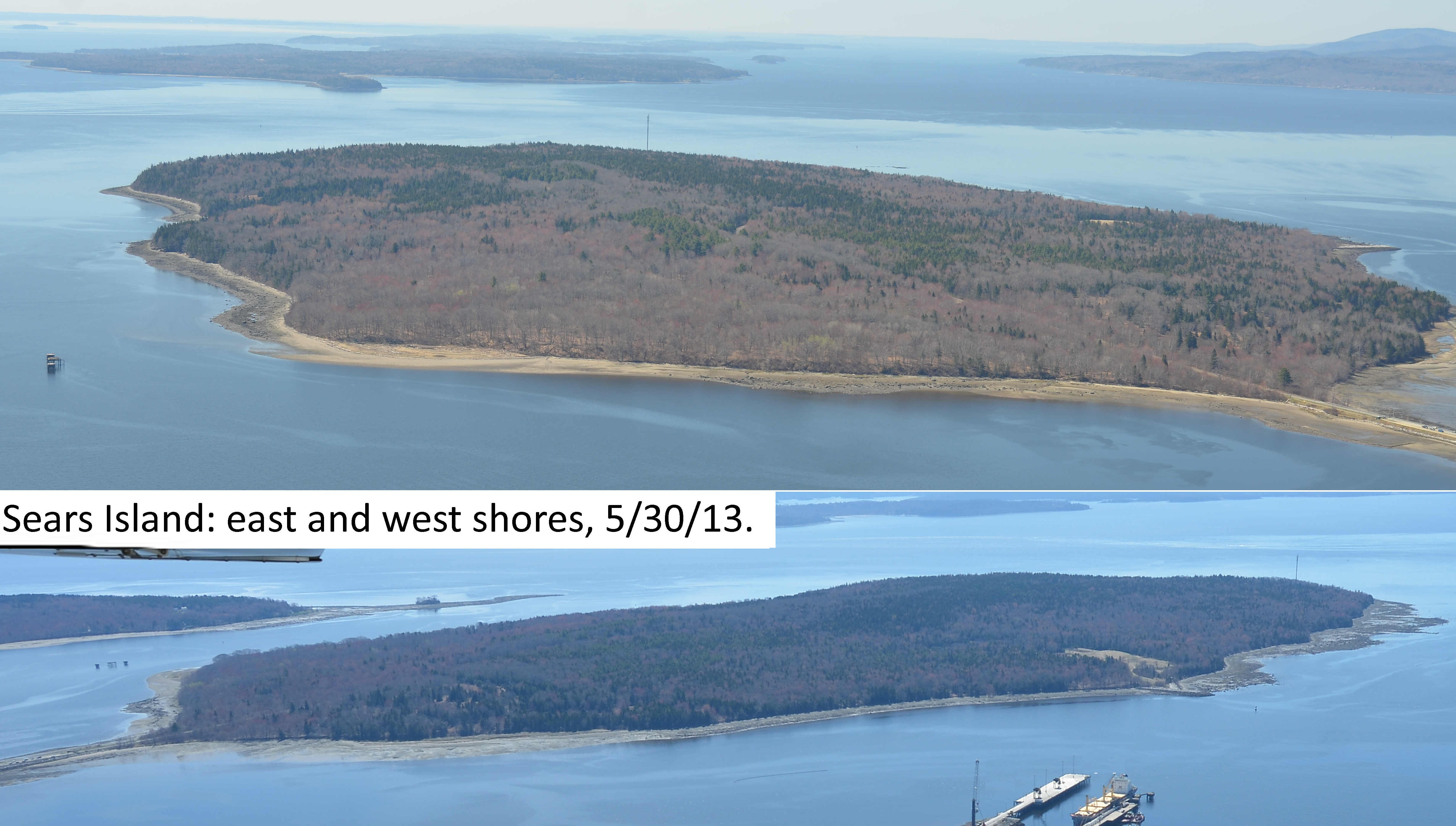
Sears Island getting fogged
Across the  continent, the  researchers at the UC Santa Cruz released a study in 2012 Total and monomethyl mercury in fog water from the central California coast.  Peter S. Weiss-Penzias, et al found that marine fog  collectively accounted for from 7–42% of elemental mercury and from 61–99% of methylmercury in total atmospheric deposition estimated for the coastal area . (Other vectors are rain, and dry deposition.)

According to that report: "These initial measurements suggest that fog precipitation may constitute an important but previously overlooked input of MMHg to coastal environments. Preliminary comparisons of these data with associated chemical, meteorological and oceanic data suggest that biotically formed MMHg from coastal upwelling may contribute to the MMHg in fog water."

While this has been shown to be the case on a portion of the California Coast, the issue has not been examined in Maine. 

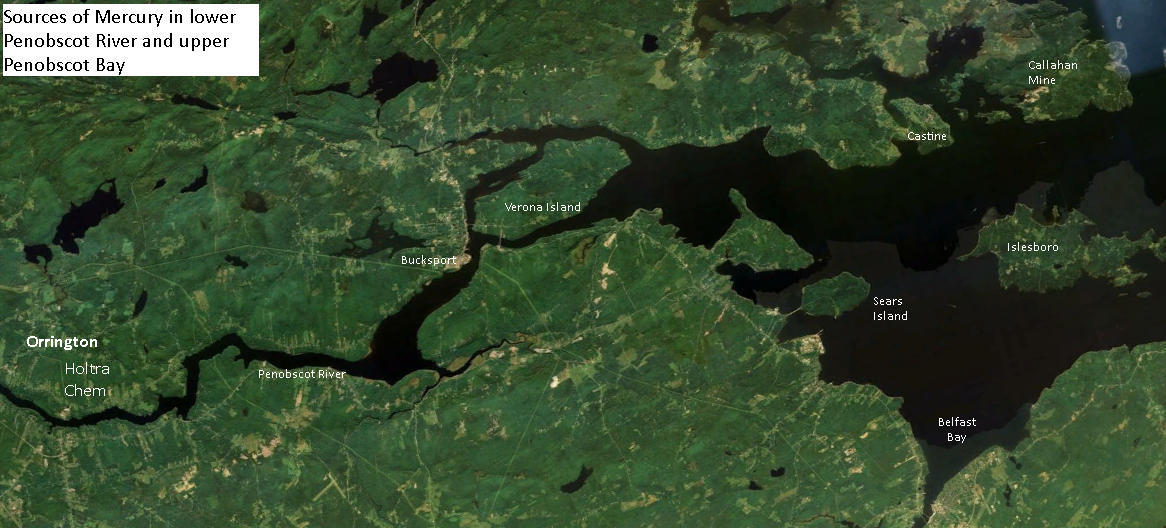
However, a significant amount of the tons of mercury spilled and leaked into the lower Penobscot River by HoltraChem has made its way into the sediments of the upper Penobscot Bay, according to a court ordered study.

In areas of the upper bay where upwelling is strong, it is likely that fog in the waters off Searsport, Belfast Stockton Springs and Islesboro and Castine could be transporting mercury to terrestrial vegetation and air breathers on the shore.

There are several prominent upwelling areas in the upper Penobscot Bay that could carry out that action: According to lobsterman Mike Dassatt,  if mercury tainted sediments are dumped in the Rockland Disposal Site  prevailing bottom currents will transport it up both sides of Islesboro and back to the upper bay. If dumped in the Belfast offshore dumpsite, strong upwelling currents there would even more quickly bring methy mercury to the surface if it were in the dredge spoils dumped there.

What is to be done?  Students at Unity College are preparing to carry out a study that will determine whether mercury can be found in the vegetation of Sears Island as well as long lived intertidal organisms.  The results of that study should be revealing.

Stay tuned.

Oct 7, 2013

Sears Island: Testing biota for HoltraChem mercury.

 Locations for testing and Recommended actions (see recs at end of essay).
AT ISSUE Reports suggest that the majority of mercury in Penobscot Bay has come down Penobscot River from spills, leaks and dumping of the element by the riverside Holtra Chem Plant  in Orrington.  History of plant.

QUESTIONS
* Can mercury be detected in the plant and animal biota of Sears Island?
 * Can it be  measured? Is it moving through island or intertidal foodwebs?

Likely origins, transport vectors, and on island-locations of mercury 
"The pattern of 
contamination of the sediments of the Penobscot River and estuary was....

consistent with a large source from the HoltraChem site at Orrington.....
"The spatial pattern of contamination of various species of biota, such as periwinkles, 
mussels, lobsters, tomcod (fish) and cormorants (birds) was also consistent with 
 
elevated inputs of Hg to the lower Penobscot River below the Veazie dam". 
.....
 [T]hese results indicate that the
 most severe contamination of the Penobscot system is between Brewer on the lower
 
river and about Fort Point or Sears Island in the upper estuary."
(Note: see maps of  study sample sites in the river and bay on page 20 of the Penobscot River Mercury Study Phase I)

SEARS ISLAND MERCURY DEPOSITION LOCATIONS
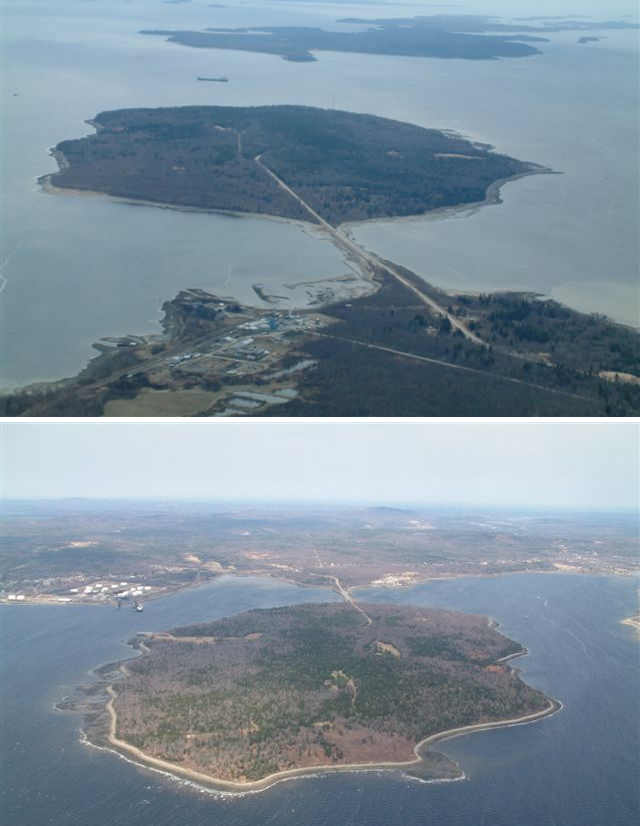
Bathymetry & hydrology questions. Does Sears Island's shape, location, hydrology and bathymetry influence where mercury might accumulate on the island?

Larger image click here
TESTING LOCATIONS
In what locations would what Sears Island biota, including intertidal and upland) be likely to absorb mercury? Particularly methyl mercury. What species might have it in detectable quantities? 

Changes in Sears Island Hydrology 
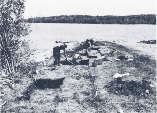
The Sears Island causeway has halted the flow of water around the island since the 980s (See a 1970s picture of causeway-free Sears Island from mainland. (courtesy  Maine Historic Preservation Commission).  Has this changed the sites of mercury deposition?

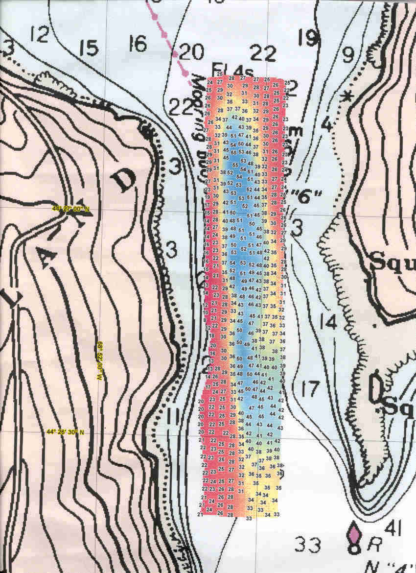
 The Jellison Channel between Sears Island and Cape Jellison was surveyed in 1999 by the NOAA vessel Rude (pronounced "Rudy"), at the request of Penobscot Bay Watch. The Rude produced this image of the channel floor (full size) The image shows that currents continue to sweep the floor of the channel clean of mud. Are those currents bringing mercury into Stockton Harbor?

Intertidal flats and beaches on the east or west sides of Sears Island

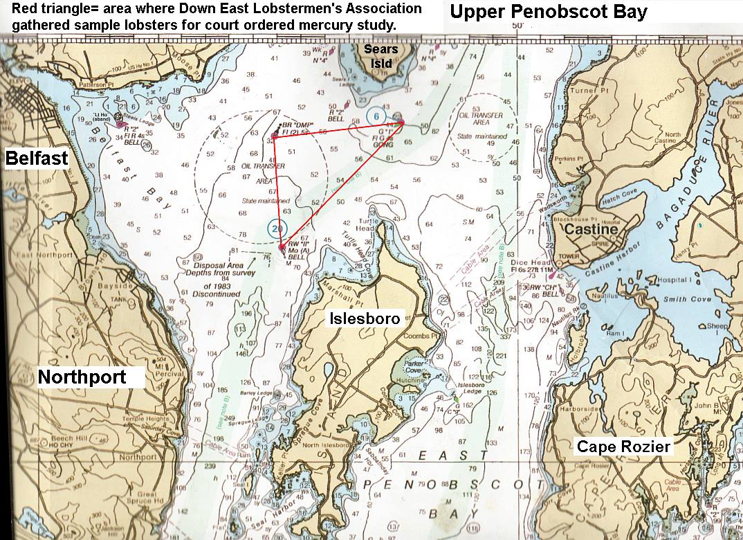
* Penobscot River Mercury Study Phase 2: Upper Penobscot Bay.  Belfast lobsterman Mike Dassatt gathered sample lobsters from the upper Bay area under a special license from DMR  for mercury examination (Red triangle).
Click here for fullsized image
 The  report has yet to be released.   Dassatt described the lobsters  collected inside the red triangle (quotes are his words) 
"There is a  pretty heavy concentration of mercury" along the line between the II Buoy and the Gong 1 Buoy. (the long edge of the triangle). 

"But the very hottest  reach is the shoal edge above  the deeper water east of  the DMP buoy", (the shoal edge is the wiggly line inside the red triangle) Mike said that while he did not take sample lobsters from the exact bay floor the Army Corps of Engineers wants to dredge, which is northeast of the DMP buoy, he is confident that the same elevated mercury will be found in that area if they do test lobsters there for it. 

Marine fog deposition of upwelling mercury onto upland vegetation.
This has not been examined in Maine to the best of our knowledge. (See 2012 UCSC paper Total and monomethyl mercury in fog water from the central California coast, Peter S. Weiss-Penzias, et al. 2012 and these  "general public" articles. 
According to that study: "[U]sing a standard fog water collector, depositions of HgT [elemental mercury] and MMHg [methylmercury] via fog were found to range from 42–4600 and 14–1500 ng m−2 y−1, which accounted for 7–42% of HgT and 61–99% of MMHg in total atmospheric deposition (fog, rain, and dry deposition), estimated for the coastal area." 

There are several prominent upwelling areas in the upper Penobscot Bay that could carry out that action: The top of the channel   According to lobsterman Mike Dassatt,  if mercury tainted sediments are dumped in the Rockland Disposal Site  prevailing bottom currents will transport it up both sides of Islesboro and back to the upper bay. 

RECOMMENDATIONS  
1.  Sample or collect plant, animal & algae species, driftwood and sediments in  intertidal areas on both sizes and both ends of Sears Island.

2. Sample or collect samples from trees and other vegetation & fungi species and soils in a transect across  Sears Island to determine if mercury deposition from fog is significant.

3. Use mercury detection  paper test strips for initial onsite  test results

4. Test for mercury and methylmercury in Unity College lab. Compare results to  mercury test strips' results.

5. Use results and determine  if initial questions can be answered:  
*  Can mercury be detected in the plant and animal biota of Sears Island?
 * Can it be  measured? Is it moving through island or intertidal foodwebs?

May 24, 2013

June 1st: help Stop the Toxic Dredge Spoil Ring around Penobscot Bay at Sears Island ghost port - by kayak, foot and boat!

Do you reject the Army Corps' proposed mercury-liberating "dredge of dreams" plan to "spoil"  upper Penobscot Bay?   You should!

On Saturday June 1st,  join other Penobscot Bay defenders at and in front of the ghost port on Sears Island, overlooking the Wasumkeag Shoal. Directions: Park on the causeway. Walk island road to ghost port.. Or walk norhtwest shore to ghost port.  Boaters' paddlers: come to the Sears Island Buoy in front of the ghost port at noon.

AT ISSUE: If Army Corps of Engineers has its way, then Prock Marine dredge gear will take an 800,000 cubic yard bite out of this shoal, Penobscot Bay's most valuable fish nursery.

This to create a ghost harbor for the Sears Island ghost port!  Watch bayhugger boats trace the perimeter of the proposed Big Diggah.

Bring your skills, energies, ideas to bear on the Task: keeping the sunken Mordor of the 19th and 20th century - lurking down in the muck beneath outer Searsport Harbor -  from rising up to cast loose a deadly ring of methylmercury around Penobscot Bay! 

For, should the Army Corps prevail, then, mercury enriched silt plumes dislodged by the dredgers' jaws will  rising off Wassumkeag and spread throughout Searsport Harbor, and to Belfast Bay, leaving a patina of the deadly metal dusting the seaweed, clams, the lobsterbait in trap, the lobsters - and  lobster eaters.

Meanwhile, mercurious spoils dumped onto the Rockland Disposal Site will, under the sway of  prevailing deep bay currents, be sent streaming back north along both sides of Islesboro, back to Belfast, to Searsport, to Castine; coming together in the shallows of the upper bay.  

So say those who fish the upper bay and know it well.   Should the Corps get approval and then dump into the site between Islesboro and Belfast instead... - the mind boggles.

Nor will  only our waterbreathing cousins imbibe this neurotoxin.   New research shows that marine methylmercury that reaches shallow waters  transfers quickly and efficiently into the microdroplets of spring and summer bay fogs. 

There it can transfer to seabirds' lungs - and yours. As well as every leaf in  our foggy coastal forests and island homes and gardens.


Keep the Army Corps of Engineers from loosing this deadly menace  upon Penobscot Bay.  Already methyl mercury levels of some upper bay lobster claws and tails  have risen above state and federal food safety notification  levels,  

One ring that could sink the hard gained marine sustainability certification of Maine lobster, by requiring mercury warning labels on live and processed lobsters from frozen tails to lobster rolls and stew.

One ring that, science shows, would bring methylmercury  to all airbreathers of the upper bay.

The Army Corps of Engineers hopes to get the okay this summer.
Some things don't change.

The people are rising against this needless dangerous plan.  

Got creative? Express your self -  at the ghost port


May 8, 2013

Has the Army Corps of Engineers declared war on Penobscot Bay lobsters?

"Big Diggah" dredge plan for Searsport could elevate mercury in bay lobsters to warning label level, putting sales of the tasty crustacean at risk.

Searsport. A federal plan to dredge a gigantic expansion of  the shipping basin off Searsport, Maine would not only be a taxpayer boondoggle; it could also resuspend so much methylmercury into Penobscot Bay's water column that lobsters and other shellfish harvested as far away as North Haven could be tainted to levels triggering mercury advisories. The dredge spoils  disrupt clams and disrupt and other filterfeeders on the bay floor for years.   

That according to critics of the project who have urged the US Army Corps of Engineers to limit its effort in Searsport Harbor to maintenance dredging of the Mack Point dock and approaches, while dropping its economically improbable, and ecologically dangerous expansion dredging plan. 

The Searsport Harbor Improvement Project would dig out up to a million tons of sediment from the floor of Searsport Harbor from two locations: the Mack Point terminals and approaches, plus an immense bite out of the shoal separating Mack Point from Sears Island.

The Friends of Penobscot Bay letter to the Corps of Engineers warned that contaminants in the sediments to be dredged would be resuspended at levels that could raise methylmercury in lobster tails and claws to levels requiring issuance of a public health advisory

The group cites the 2008 Penobscot River Mercury Study ordered by Federal judge Gene Carter to determine how much mercury the now defunct HoltraChem company had leaked or spilled into the tidal Penobscot River in Orrington.   

The study examined samples of sediment, fish and shellfish taken from the waters off the Holtrachem site, downriver, and throughout the upper bay to Vinalhaven. It found  high levels of the potent neurotoxin methylmercury (MeHg) were in the sediments closest to the holtrachem plant, tapering off downstream until reaching the upper bay, where the level of methylmercury rose again, tapering off to background levels in Vinalhaven

According to the report: "At the eight upper estuary sites (see map Figure 36), of 67 lobster sampled, 25% exceeded the MDEP criterion of 200 ng/g w.w. MeHg and 6% exceeded the USEPA criterion of 300 ng/g. This was calculated from the mean of total Hg in claws and tails (from individual total Hg concentration in claws assuming tail muscle was 53% higher in total Hg) and that 75% of the total Hg in both tissues was MeHg."

The Friends of Penobscot Bay warned the Corps that 
"some of the most elevated  levels of mercury in lobster claws was in samples taken less than a mile away from the area proposed for improvement dredging. If more mercury were resuspended as a result of dredging, then the contaminated lobster zone – in that location already well above EPA toxicity limits – could spread to a far greater part of the bay"

The group warned  of economic disaster to the region if public health laws mandate posting a 
 mercury advisory on Penobscot Bay lobsters and processed lobster products.

Thanks But No Tank's letter  to the Army Corps of Engineers challenges the Corps' claim that dredging is required to accommodate deep draft vessels presently using the existing terminals at the port. TBNT's attorney Steve Henchman wrote that this claim "is expressly contradicted by all of the Corps’ prior representations about Mack Point and the port of`Searsport, published in the 2012 EA regarding the proposed DCP Searsport LLC LPG marine import terminal at Mack Point."

"In that 2012 EA," the group attorney Steve Hinchman wrote, "the Corps concluded that "no dredging” would be required to accommodate the 4 to 8 ocean-going, deep draft LPG tankers that the DCP facility would have been serviced by annually — ships with an anticipated draft of up to 39.7 feet"

TBNT called this "proof that the assertions of need for the proposed "improvement" dredging in the April 5, 2013, Feasibility Study, and draft EA, FONSI and CWA letter are arbitrary and capricious — unsupported even by the Corps’ own prior, recent findings about the
safety and adequacy of this port area — without any dredging — for a significant increase in large, ocean-going, deep draft tanker trafiic."

"Despite having thirteen years to conduct a thorough assessment of the alleged need to deepen the channel and pier area of Mack Point," Hinchman wrote, "the cursory and out-dated analysis on which the Corps’ April 5th Feasibility Study and draft EA, FONSI and Clean Water Act (CWA) letter, is based fails to adequately consider the potentially significant environmental damage that the direct and indirect, primary and secondary consequences of the proposed "improvement dredging" would wreak on the fragile environment of Upper Penobscot Bay, and the Bay as a whole from the dumping of almost a million cubic yards of dredge spoils that potentially contain significant contaminants (including mercury. "

Down East Lobstermens Association also wrote to the Corps of Engineers in opposition to the dredge expansion project.   DELA regularly samples the area for pollutants They warned of the complexity of the water circulation at the top of the bay and called for a public hearing and environmental impact study to learn the extent  of  methylmercury contamination of bottom dwelling species that the project would bring, and how badly the fine sediments resuspended en mass into the bay water column would suffocate bay plankton and clamsn and other filterfeeders... According to the group, dredging in the region in the past  depressed lobster fishering in the upper bay for nearly a decade.

"Everyone hopes that the Army Corps of Engineers will drop its "dig it and they will come"  expansion plan  fantasy," said Huber.  They must not throw Penobscot Bay's lobster fishery under the bus." for a completely unnecessary expansion dredging project could taint the bay's lobsters with  enough of this dangerous neurotopxin compound to require lobster processors  to add mercury advisory labels to their product packaging when made from Penobscot Bay lobsters." Friends of Penobscot Bay's spokesperson Ron Huber said. 

BACKGROUND INFO  (Courtesy TBNT)

37,000 cubic yards of dredge materials would be removed as maintenance dredging.
This would maintain the current federally authorized 35’ depth of the existing channel, tum around and pier areas.  
892,000 cy of dredge spoils have to be removed  for the "improvement" project

An additional  31,000 cubic yards of dredge spoils would be removed from the pier area. 

The existing entrance channel and turning basin would be deepened from 35’ to a depth of 40 
The entrance channel would be widened from its current 500’ at the narrowest point to 650’, 
A maneuvering area would be created in Long Cove adjacent to the east berth along the State Pier.

The rectangular maneuvering area would be  875’ on the west side and 1,066’ on the east side 
A width of 400’. This area would also be deepened to 40’ MLLW.

END