At the October 10th Searsport planning board meeting, several things became apparent as a succession of area residents spoke to the assembled officials about the plan to build an enormous Liquified Petroleum Gas storage tank on Mack Point in Searsport. (
Red letter A points to proposed super LPG tank location on Mack Point, viewed from dock on Cape Jellison).
Several months ago the Planning Board approved raising the height limitation on Mack Point, paving the way for
DCP Midstream LLC to apply to build the giant tank that would hulk above the skyline, unlike all the other energy companies with tanks at Mack Point. The thing is so big that it would be both chronic view pollution and an incredibly dangerous potential threat.
Five local citizens with concerns about the tank plan attended the meeting and asked for an economic impact study. Bruce Probert, Chairman of the Planning Board, asked for specifics to be included in the study. "At what point should we do an economic impact study? Why should we do a study about DCP" he said, " and not other businesses?
The citizens obliged with a list of answers to his questions, including tax revenues and revenue sharing reductions by the State. How many jobs at what salaries? (no guarantee they will hire local). What about wear and tear on roads, more time (and traffic delays) doing maintenance + costs. What about the impact on local businesses if AAA routes tourists via I-95 to get to Acadia to avoid the unsightly dangerous tank farm, there is a real potential for loss of business (shopping and restaurants) if tourist traffic through the area diminishes. Increased staffing of police and fire departments. Impact on property values.
Some reminded the board that many of us have moved to the area and made major investments in our homes and businesses. The tank will discourage people from moving to Searsport or anywhere on the Bay within sight and reach of the tank.
Activities in the Bay and disruption to other shipping is the jurisdiction of the Coast Guard. Seismic activity on Sears Island is the jurisdiction of the Army Corps of Engineers.
Comments by some Planning Board members show their support for the tank. Bruce Probert read all the different standards in the ordinance that DCP has to meet. Including state laws. One realizes why they are proposing such large amounts of ecological blood money. also known as compensatory mitigation: ther eis no possible way that the project would fit harmoniously into its surroundings, and another had to do with visual pollution.
How they will try to get round those two items is unclear But if they do, and the DCP application is received by the Searsport Planning Board and deemed to be complete, the Board has to give an up or down vote within 30 days. During that 30 day period there will be a public hearing.
In addition to the Army Corps of Engineers' Jay Clement, the US Coast Guard's ____ and the Maine Dept of Environmental Protection's Robin Clukey, the fate of the people and wildlife of the upper bay is in the hands of Bruce Probert and the other four gentlemen on the Searsport Planning Board.


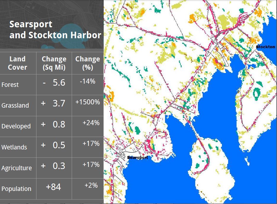
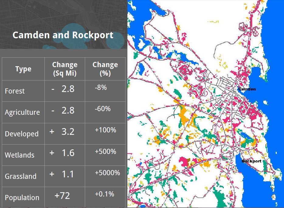
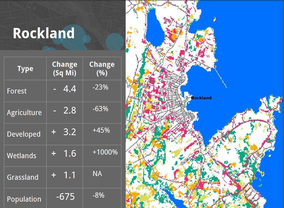
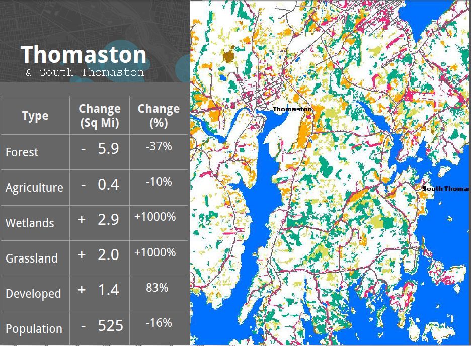
 Summary According to a report prepared earlier August 17, 2015 for Friends of Penobscot Bay, western bay towns Stockton Springs, Searsport, Belfast, Camden, Rockport, Rockland and South Thomaston lost about 30 square miles of forests between 1992 and 2011.
 Stockton Springs & Searsport together lost 14% of their forest cover: 5 and a half square miles. Population increase of 84 people since 1990.
 Belfast lost 4 square miles 15% of its forests. About 2 square miles became developed land. While development went up 50%, the population only went up 4%. More details here
 Camden & Rockport lost 8% of their forestland. 3 square miles become developed land. 100% increase in development Lost almost 3 sq miles to development.
  Rockland & SW Rockport lost 23% of their forest cover. 45% increase in developed land Population of the city dropped 8%, from 7,900 down to 7,200 between 1992 and 2011.