Showing posts with label :Penobscot River. Show all posts
Showing posts with label :Penobscot River. Show all posts
Nov 23, 2018
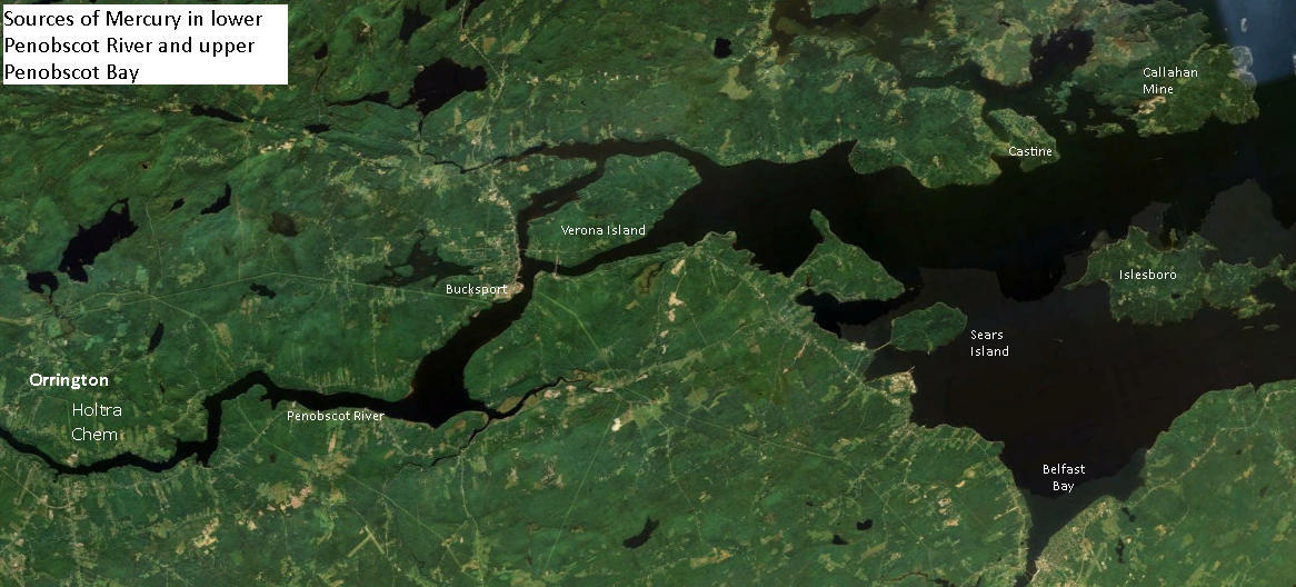
Mercury levels off Bucksport: safe for RAS salmon farming?
From: Lower Penobscot River Mercury Study 2006-2007 See study documents repository
Sample study site PBR 27B is next to Whole Oceans proposed RAS salmon tankfarm location.

In Figure 5-9 , below, study site PBR 27B is 5th highest of 24 sample sites tested
 |
Feb 25, 2014
Searsport Harbor dredge plan public info meeting in Bangor 2/24/14 AUDIO
 Audio recordings from the February 24, 2014 public information meeting on the proposal to expansion-dredge Searsport Harbor, held at the Cross Center, in Bangor, Maine.
A powerful showing by Penobscot Bay's fishing community thwarted Maine DEP's seeming plan to reduce public participation by moving the event more than 30 miles from Searsport.
Introduction to the meeting 5 minutes
 |
| Barbara Blumeris. John Henshaw in background |
Speaker 2 Steve Wolfe Army Corps of Engineers
* Part 1. All about dredging. 13 minutes
* Part 2 About dumping dredge spoils 20 minutes
PUBLIC SPEAKERS
 1. Intro and Ron Huber, Friends of Penobscot Bay 2min35sec
2, Arch Gillies, Islesboro Selectboard 3min 10sec
3. Robert Young, Young's Seafood. 2min 45sec
4. Tony Kulik 2min 15sec
5. Representative Joe Brooks Winterport & Q&A 4min 14sec
6. Meredith Ares, Searsport Selectboard & Q&A. 2min 37sec
7. Nancy Galland & Q&A 5 minutes

8. Anne Crimaudo 50 seconds
9. John Porter, Bangor Chamber of Commerce 2min5sec
10.Bob Zeiglar, ME Port Authority 95sec
11. Bud Hall, Angler's Restaurant + Q &A 6min.
12. Patrice McCarron Maine Lobstermens Association 3min
13. Nancy Daley 2min 41 sec.
14. Harlan McLaughlin FOPB and Q&A 3min
15. Steve Hinchman 3min 15sec
16. Army Corps explains why it's there 75sec
17. David Cole 4 min
18. Mike Dassatt, Belfast lobsterman 2min
19. Unnamed Southwest Harbor resident 3min 15sec
20 Steve Miller and Q&A 5min 40sec
21. Penobscot River & Bay Pilots 2min
22. Amy Browne WERU 2min 28sec
23. Christian Smith, Fisherman 1min 40sec
24. Nick Battista, Island Institute 2min 45sec
25. Becky Bartovics, Sierra Club 3min 30sec
26. Army Corps, Final remarks 50 sec
Oct 7, 2013
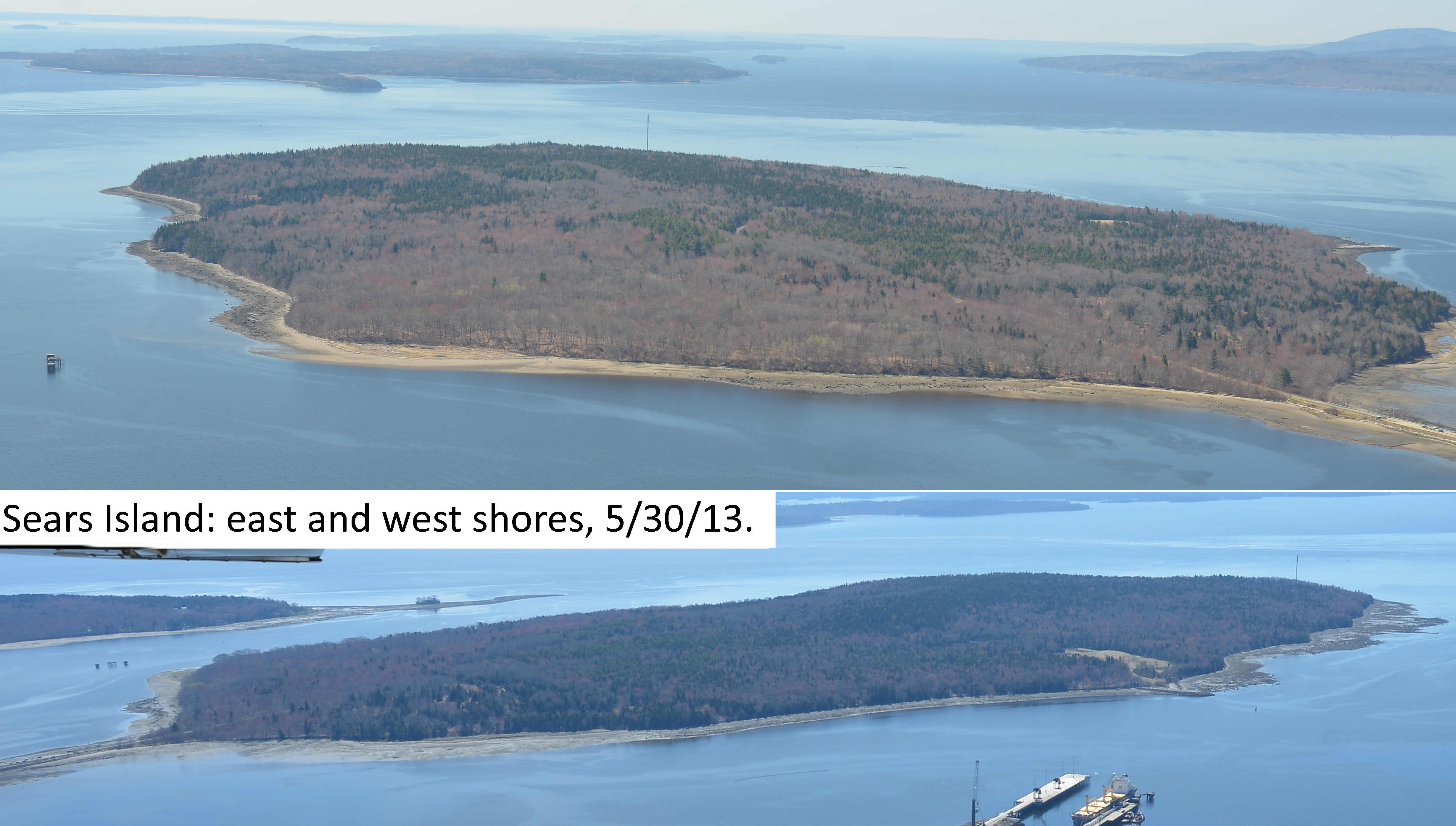
Sears Island: Testing biota for HoltraChem mercury.
Locations for testing and Recommended actions (see recs at end of essay).
AT ISSUE Reports suggest that the majority of mercury in Penobscot Bay has come down Penobscot River from spills, leaks and dumping of the element by the riverside Holtra Chem Plant in Orrington. History of plant.
QUESTIONS
* Can mercury be detected in the plant and animal biota of Sears Island?
* Can it be measured? Is it moving through island or intertidal foodwebs?

Likely origins, transport vectors, and on island-locations of mercury
According to the Penobscot River Mercury Study Phase I: 2006-2007 Report to Judge Gene Carter, U.S. District Court:
 "The pattern of
contamination of the sediments of the Penobscot River and estuary was....
consistent with a large source from the HoltraChem site at Orrington.....
"The spatial pattern of contamination of various species of biota, such as periwinkles,
mussels, lobsters, tomcod (fish) and cormorants (birds) was also consistent with
elevated inputs of Hg to the lower Penobscot River below the Veazie dam".
.....
[T]hese results indicate that the
most severe contamination of the Penobscot system is between Brewer on the lower
river and about Fort Point or Sears Island in the upper estuary."
(Note: see maps of study sample sites in the river and bay on page 20 of the Penobscot River Mercury Study Phase I)
SEARS ISLAND MERCURY DEPOSITION LOCATIONS
Bathymetry & hydrology questions. Does Sears Island's shape, location, hydrology and bathymetry influence where mercury might accumulate on the island?
 |
| Larger image click here |
TESTING LOCATIONS
In what locations would what Sears Island biota, including intertidal and upland) be likely to absorb mercury? Particularly methyl mercury. What species might have it in detectable quantities?
Army Corps of Engineers' map of its sediment test sites in Searsport Harbor.
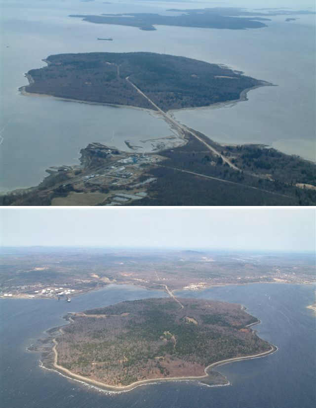
Changes in Sears Island Hydrology
The Sears Island causeway has halted the flow of water around the island since the 980s (See a 1970s picture of causeway-free Sears Island from mainland. (courtesy Maine Historic Preservation Commission). Has this changed the sites of mercury deposition?
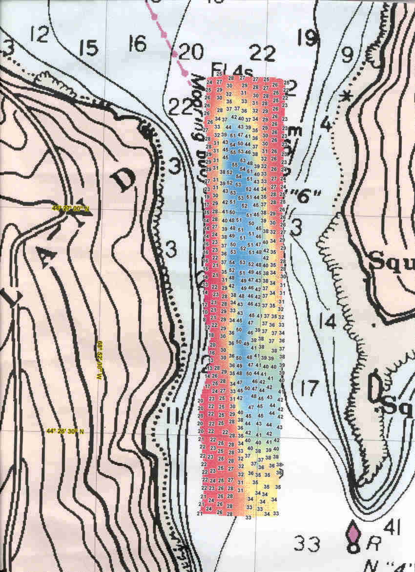
The Jellison Channel between Sears Island and Cape Jellison was surveyed in 1999 by the NOAA vessel Rude (pronounced "Rudy"), at the request of Penobscot Bay Watch. The Rude produced this image of the channel floor (full size) The image shows that currents continue to sweep the floor of the channel clean of mud. Are those currents bringing mercury into Stockton Harbor?
Intertidal flats and beaches on the east or west sides of Sears Island

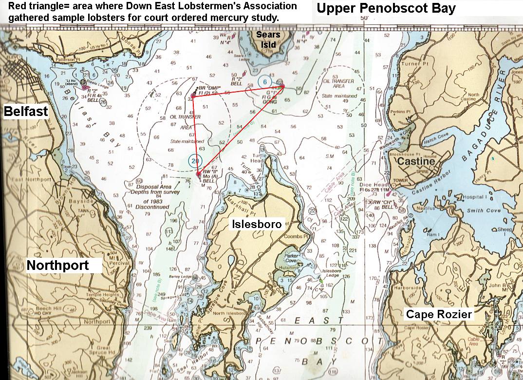
* Penobscot River Mercury Study Phase 2: Upper Penobscot Bay. Belfast lobsterman Mike Dassatt gathered sample lobsters from the upper Bay area under a special license from DMR for mercury examination (Red triangle).
 |
| Click here for fullsized image |
The report has yet to be released. Dassatt described the lobsters collected inside the red triangle (quotes are his words)
"There is a pretty heavy concentration of mercury" along the line between the II Buoy and the Gong 1 Buoy. (the long edge of the triangle).
"But the very hottest reach is the shoal edge above the deeper water east of the DMP buoy", (the shoal edge is the wiggly line inside the red triangle) Mike said that while he did not take sample lobsters from the exact bay floor the Army Corps of Engineers wants to dredge, which is northeast of the DMP buoy, he is confident that the same elevated mercury will be found in that area if they do test lobsters there for it.
Marine fog deposition of upwelling mercury onto upland vegetation.


This has not been examined in Maine to the best of our knowledge. (See 2012 UCSC paper Total and monomethyl mercury in fog water from the central California coast, Peter S. Weiss-Penzias, et al. 2012 and these "general public" articles.
According to that study: "[U]sing a standard fog water collector, depositions of HgT [elemental mercury] and MMHg [methylmercury] via fog were found to range from 42–4600 and 14–1500 ng m−2 y−1, which accounted for 7–42% of HgT and 61–99% of MMHg in total atmospheric deposition (fog, rain, and dry deposition), estimated for the coastal area."
There are several prominent upwelling areas in the upper Penobscot Bay that could carry out that action: The top of the channel According to lobsterman Mike Dassatt, if mercury tainted sediments are dumped in the Rockland Disposal Site prevailing bottom currents will transport it up both sides of Islesboro and back to the upper bay.
RECOMMENDATIONS
1. Sample or collect plant, animal & algae species, driftwood and sediments in intertidal areas on both sizes and both ends of Sears Island.
2. Sample or collect samples from trees and other vegetation & fungi species and soils in a transect across Sears Island to determine if mercury deposition from fog is significant.
3. Use mercury detection paper test strips for initial onsite test results
4. Test for mercury and methylmercury in Unity College lab. Compare results to mercury test strips' results.
5. Use results and determine if initial questions can be answered:
* Can mercury be detected in the plant and animal biota of Sears Island?
* Can it be measured? Is it moving through island or intertidal foodwebs?May 8, 2013
Has the Army Corps of Engineers declared war on Penobscot Bay lobsters?
"Big Diggah" dredge plan for Searsport could elevate mercury in bay lobsters to warning label level, putting sales of the tasty crustacean at risk.
 That according to critics of the project who have urged the US Army Corps of Engineers to limit its effort in Searsport Harbor to maintenance dredging of the Mack Point dock and approaches, while dropping its economically improbable, and ecologically dangerous expansion dredging plan.
mercury advisory on Penobscot Bay lobsters and processed lobster products.

Searsport. A federal plan to dredge a gigantic expansion of the shipping basin off Searsport, Maine would not only be a taxpayer boondoggle; it could also resuspend so much methylmercury into Penobscot Bay's water column that lobsters and other shellfish harvested as far away as North Haven could be tainted to levels triggering mercury advisories. The dredge spoils disrupt clams and disrupt and other filterfeeders on the bay floor for years.
That according to critics of the project who have urged the US Army Corps of Engineers to limit its effort in Searsport Harbor to maintenance dredging of the Mack Point dock and approaches, while dropping its economically improbable, and ecologically dangerous expansion dredging plan.
The Searsport Harbor Improvement Project would dig out up to a million tons of sediment from the floor of Searsport Harbor from two locations: the Mack Point terminals and approaches, plus an immense bite out of the shoal separating Mack Point from Sears Island.
The Friends of Penobscot Bay letter to the Corps of Engineers warned that contaminants in the sediments to be dredged would be resuspended at levels that could raise methylmercury in lobster tails and claws to levels requiring issuance of a public health advisory
The group cites the 2008 Penobscot River Mercury Study ordered by Federal judge Gene Carter to determine how much mercury the now defunct HoltraChem company had leaked or spilled into the tidal Penobscot River in Orrington.
The study examined samples of sediment, fish and shellfish taken from the waters off the Holtrachem site, downriver, and throughout the upper bay to Vinalhaven. It found high levels of the potent neurotoxin methylmercury (MeHg) were in the sediments closest to the holtrachem plant, tapering off downstream until reaching the upper bay, where the level of methylmercury rose again, tapering off to background levels in Vinalhaven
According to the report: "At the eight upper estuary sites (see map Figure 36), of 67 lobster sampled, 25% exceeded the MDEP criterion of 200 ng/g w.w. MeHg and 6% exceeded the USEPA criterion of 300 ng/g. This was calculated from the mean of total Hg in claws and tails (from individual total Hg concentration in claws assuming tail muscle was 53% higher in total Hg) and that 75% of the total Hg in both tissues was MeHg."
The Friends of Penobscot Bay warned the Corps that
"some of the most elevated levels of mercury in lobster claws was in samples taken less than a mile away from the area proposed for improvement dredging. If more mercury were resuspended as a result of dredging, then the contaminated lobster zone – in that location already well above EPA toxicity limits – could spread to a far greater part of the bay"
The group warned of economic disaster to the region if public health laws mandate posting a
Thanks But No Tank's letter to the Army Corps of Engineers challenges the Corps' claim that dredging is required to accommodate deep draft vessels presently using the existing terminals at the port. TBNT's attorney Steve Henchman wrote that this claim "is expressly contradicted by all of the Corps’ prior representations about Mack Point and the port of`Searsport, published in the 2012 EA regarding the proposed DCP Searsport LLC LPG marine import terminal at Mack Point."
"In that 2012 EA," the group attorney Steve Hinchman wrote, "the Corps concluded that "no dredging” would be required to accommodate the 4 to 8 ocean-going, deep draft LPG tankers that the DCP facility would have been serviced by annually — ships with an anticipated draft of up to 39.7 feet"
TBNT called this "proof that the assertions of need for the proposed "improvement" dredging in the April 5, 2013, Feasibility Study, and draft EA, FONSI and CWA letter are arbitrary and capricious — unsupported even by the Corps’ own prior, recent findings about the
safety and adequacy of this port area — without any dredging — for a significant increase in large, ocean-going, deep draft tanker trafiic."
"Despite having thirteen years to conduct a thorough assessment of the alleged need to deepen the channel and pier area of Mack Point," Hinchman wrote, "the cursory and out-dated analysis on which the Corps’ April 5th Feasibility Study and draft EA, FONSI and Clean Water Act (CWA) letter, is based fails to adequately consider the potentially significant environmental damage that the direct and indirect, primary and secondary consequences of the proposed "improvement dredging" would wreak on the fragile environment of Upper Penobscot Bay, and the Bay as a whole from the dumping of almost a million cubic yards of dredge spoils that potentially contain significant contaminants (including mercury. "
Down East Lobstermens Association also wrote to the Corps of Engineers in opposition to the dredge expansion project. DELA regularly samples the area for pollutants They warned of the complexity of the water circulation at the top of the bay and called for a public hearing and environmental impact study to learn the extent of methylmercury contamination of bottom dwelling species that the project would bring, and how badly the fine sediments resuspended en mass into the bay water column would suffocate bay plankton and clamsn and other filterfeeders... According to the group, dredging in the region in the past depressed lobster fishering in the upper bay for nearly a decade.
"Everyone hopes that the Army Corps of Engineers will drop its "dig it and they will come" expansion plan fantasy," said Huber. They must not throw Penobscot Bay's lobster fishery under the bus." for a completely unnecessary expansion dredging project could taint the bay's lobsters with enough of this dangerous neurotopxin compound to require lobster processors to add mercury advisory labels to their product packaging when made from Penobscot Bay lobsters." Friends of Penobscot Bay's spokesperson Ron Huber said.
BACKGROUND INFO (Courtesy TBNT)
37,000 cubic yards of dredge materials would be removed as maintenance dredging.
This would maintain the current federally authorized 35’ depth of the existing channel, tum around and pier areas.
892,000 cy of dredge spoils have to be removed for the "improvement" project
An additional 31,000 cubic yards of dredge spoils would be removed from the pier area.
The existing entrance channel and turning basin would be deepened from 35’ to a depth of 40
The entrance channel would be widened from its current 500’ at the narrowest point to 650’,
A maneuvering area would be created in Long Cove adjacent to the east berth along the State Pier.
The rectangular maneuvering area would be 875’ on the west side and 1,066’ on the east side
A width of 400’. This area would also be deepened to 40’ MLLW.
END
Oct 28, 2012
Licensed outfalls of Penobscot Bay and tidal Penobscot River.
Source US EPA
TIDAL PENOBSCOT RIVER
| Tenants Harbor (Tenants Harbor) | East Wind Inc. (PDF) (24 pp, 1.1MB) | ME0036765 | 04/20/2006 |
| Saint George (Atlantic Ocean) | East Wind Incorporated (PDF) (2 pp, 2MB) | ME0036773 | 07/18/2011 |
| St. George (Long Cove) | Great Eastern Mussel Farms, Inc. (PDF) (42 pp, 2.1MB) | ME0023124 | 11/08/2007 |
| Owls Head (Atlantic Ocean) | Crescent Beach Association (PDF) (40 pp, 2.8MB) | ME0036781 | 11/30/2010 |
| Owls Head (Atlantic Ocean) | Crescent Beach Association (PDF) (30 pp, 1.3MB) | ME0036781 | 11/29/2005 |
| Rockland (Atlantic Ocean) | Rockland POTW, City of (PDF) (25 pp, 216K) | ME0100595 | 11/21/2009 |
| Rockland (Atlantic Ocean) | Rockland POTW, City of (PDF) (84 pp, 229K) | ME0100595 | 12/21/2007 |
| Rockland (Rockland Harbor) | Rockland POTW, City of (PDF) (13 pp, 102K) | ME0100595 | 01/31/2008 |
| Rockland (Rockland Harbor) | Rockland, City of; Waste Snow Dump (PDF) (29 pp, 2MB) | ME0036323 | 04/12/2012 |
| Rockland (Rockland Harbor) | Rockland, City of; Waste Snow Dump (PDF) (15 pp, 817K) | ME0036323 | 12/28/2006 |
| Rockland (Rockland Harbor) | FMC Biopolymer (PDF) (31 pp, 1.59MB) | ME0000400 | 10/09/2007 |
| Rockland (Rockland Pier) | Dragon Products Company, LLC (PDF) (16 pp, 45K) | ME0036994 | 11/25/2008 |
| Rockport (Rockport Harbor) | Rockport, Town of (PDF) (16 pp, 649K) | ME0036307 | 10/03/2006 |
| Camden (Camden Harbor Watershed) | Camden, Town of (PDF) (32 pp, 3MB) | ME0100137 | 07/18/2003 |
| Camden (Camden Harbor) | Camden Waste Snow Dump, Town of (PDF) (29 pp, 1.2MB) | ME0102725 | 08/05/2010 |
| Camden (Megunticook River) | Camden Waste Snow Dump, Town of (PDF) (13 pp, 643K) |
| Northport | Atlantic Blanket Company (PDF) (33 pp, 2.3MB) | MEU508257 | 12/02/2010 |
| Belfast | Moore’s Septic, Inc. (PDF) (40 pp, 3.2MB) | MEU508259 | 10/03/2012 |
| Belfast (Atlantic Ocean, Belfast Harbor) | Belfast POTW, City of (PDF) (81 pp, 3.2MB) | ME0101532 | 02/18/2011 |
| Belfast (Belfast Harbor) | Belfast POTW, City of (PDF) (5 pp, 24K) | ME0101532 | 02/12/2008 |
| Belfast (Belfast Harbor) | Belfast POTW, City of (PDF) (64 pp, 3MB) | ME0101532 | 05/23/2006 |
| Belfast (Passagassawakeag River) | Penobscot Mccrum, LLC (PDF) (64 pp, 2.5MB) | ME0023043 | 10/17/2007 |
| Searsport (Atlantic Ocean/Stockton Harbor) | General Alum New England Corporation Chemical Manufacturing Facility (PDF) (42 pp, 3MB) | ME0001830 | 03/03/2011 |
| Searsport (Long Cove, Penobscot Bay) | Irving Oil Terminals, Inc. (PDF) (75 pp, 2.3MB) | ME0002461 | 04/09/2010 |
| Searsport (Penobscot Bay) | Searsport, Town of (PDF) (79 pp, 1.4MB) | ME0101966 | 11/12/2008 |
| Searsport (Searsport Harbor) | Irving Oil Terminals, Inc. (PDF) (70 pp, 2.2MB) | ME0021181 | 04/09/2010 |
| Searsport (Searsport Tidewaters) | Sprague Energy Corporation (PDF) (73 pp, 14.3MB) | ME0002208 | 09/14/2009 |
| Searsport (Searsport) | Sprague Energy Corporation (PDF) (27 pp, 1.3MB) | ME0002208 | 12/15/2006 |
| Searsport (Stockton Harbor) | GAC Chemical Corporation (PDF) (30 pp, 1.6MB) | ME0001830 | 03/21/2006 |
| Islesboro (East Penobscot Bay) | Islesboro, Town of (PDF) (11 pp, 1.8MB) | ME0100269 | 01/20/2012 |
| Islesboro (East Penobscot Bay) | Islesboro, Town of (PDF) (25 pp, 1.3MB) | ME0100269 | 11/21/2005 |
| Penobscot (Penobscot River) | School Union 93 (PDF) (21 pp, 71K) | ME0101974 | 08/28/2008 |
| Castine | Castine POTW, Town of (PDF) (15 pp, 55K) | ME0101192 | 03/12/2008 |
| Castine (Castine Harbor) | Castine POTW, Town of (PDF) (77 pp, 2.3MB) | ME0101192 | 12/29/2009 |
| North Haven (Fresh Pond) | North Haven DWTP, Town of (PDF) (34 pp, 1.1MB) | ME0102482 | 08/02/2012 |
| North Haven (Fresh Pond) | North Haven DWTP, Town of (PDF) (22 pp, 1.1MB) | ME0102482 | 06/15/2007 |
| Vinalhaven (Atlantic Ocean) | Vinalhaven POTW, Town of (PDF) (49 pp, 2.1MB) | ME0102491 | 11/15/2007 |
| Bucksport | Bucksport, Town of (PDF) (65 pp, 4.1MB) | ME0100111 | 04/10/2012 |
| Bucksport | Verso Bucksport LLC (PDF) (23 pp, 1.4MB) | ME0002160 | 06/07/2012 |
| Bucksport | Verso Bucksport LLC (PDF) (22 pp, 1.8MB) | ME0002160 | 09/02/2010 |
| Bucksport (Penobscot River) | Verso Bucksport LLC (PDF) (65 pp, 3.3MB) | ME0002160 | 01/07/2010 |
| Bucksport (Penobscot River) | Webber Tanks, Inc. Bulk Fuel Storage Facility (PDF) (68 pp, 16.1MB) | ME0001457 | 10/15/2010 |
| Bucksport (Penobscot River) | Webber Tanks, Inc. Bulk Fuel Storage Facility (PDF) (28 pp, 1.3MB) | ME0001457 | 04/25/2006 |
| Winterport (Penobscot River) | Winterport Water District (PDF) (61 pp, 3.6MB) | ME0100749 | 04/02/2012 |
| Orrington (Penobscot River) | Penobscot Energy Recovery Co. (PDF) (67 pp, 2.6MB) | ME0023230 | 08/26/2009 |
| Bangor (Penobscot River) | Webber Oil Company Bulk Fuel Storage Facility (PDF) (43 pp, 2.2MB) | ME0022225 | 05/19/2010 |
| Bangor (Penobscot River) | Webber Oil Company (PDF) (28 pp, 1.5MB) | ME0022225 | 04/25/2006 |
| Bangor (Penobscot River, Kenduskeag Stream ) | Bangor POTW (PDF) (135 pp, 4.4MB) | ME0100781 | 05/26/2011 |
| Brewer (Penobscot River) | Brewer POTW (PDF) (111 pp, 2.7MB) | ME0100072 | 05/19/2011 |
| Brewer (Penobscot River) | Brewer POTW (PDF) (34 pp, 933K) | Fact Sheet (PDF) (16 pp, 297K) | ME0100072 | 04/25/2003 |
| Brewer (Penobscot River) | CES Inc. (PDF) (16 pp, 742K) | ME0102695 | 11/04/2005 |
Feb 29, 2012
DCP tank plan - email the Corps of Engineers TODAY
Jay Clement wants to hear from you by 5pm today about the DCP tank plan. Send him this:
add your name and personal additions to the email.
February 29, 2012
Jay Clement
US Army Corps of Engineers
Maine Project Office
675 Western Avenue #3
Manchester, Maine 04351
Subject: DCP Midstream LPG Tank plan
Dear Mr. Clement
The Army Corps of Engineers require require a public hearing and an Environmental Impact Study be done of the DCP Midstream LLC plan for a Liquified Petroleum Gas tank in Searsport.
This should be done before deciding whether or not to grant the company a Rivers & Harbors Act permit and a Clean Water Act permit to build its project.
The tank would have effects on people, fish and wildlife down Penobscot Bay and up Penobscot River. None of these have been considered yet. For that reason the public hearing and Environmental impact study are needed.
Sincerely
Dec 14, 2011
Maine foes of Colorado-based DCP Midstream's supertank plan appeal to top federal brass.
 Searsport. Angry residents of the bayside town of Searsport, Maine, and neighboring towns, along with a variety of citizens' groups, are reacting sharply to word that the officials of the US Army Corps of Engineers in that agency's Maine state projects office are poised to conclude that no environmental review is needed of DCP Midstream company's controversial plan to site the East coast's biggest Liquified Petroleum Gas storage "supertank" in their town, overlooking scenic Penobscot Bay. They Are reaching out to Army Corps Headquarters, damanding an impartial wetlands review of the soggy coastal forest that the company proposes to take a 30 acre bite out of.
The project has already received a state permit which is being appealed in Maine Superior Court by area citizens including a grassroots organization Thanks But No Tank! that has sprung up in defense of the scenic and economically successful balance of industry and world class scenery-powered tourism, sailing and lobstering that Penobscot Bay is renowned for.
But mindful of the looming Army Corps of Engineers decision, to be inked this week by Maine Proects office reviewer Jay Clement, on whether to award DCP a "General Permit" or mandate a more sweeping review under federal wetlands rules and law sokaying a federal permits that DCP Midstream must also seek, critics are reaching out to the leaders of the US Army Corps of Engineers' civil works program, including:

* Jo-Ellen Darcy, Asst Secretary of the Army Civil Works,
* Steven L. Stockton, Director of Civil Works for the agency,
* Michael Ensch, Chief of Operations for Civil Works,
* Meg Gaffney-Smith. Chief, of the Corps' Regulatory Branch, and
* Colonel Charles P. Samaris, Commander and District Engineer for New England
AT ISSUE is the looming decision by the Corps of Engineers' Maine projects' reviewer Jay Clement, to declare that out of the more than 20 acres of wetlands filling the 30 acre coastal forest that DCP would clear and pave, only 2 and 3/4 acres are "jurisdictional" wetlands. Yet a review by a third party suggests that far more acres of the site's wetlands meet the standard than DCP Midstream's hired wetlands consultant claims.

This has raised suspicions among area residents familiar with the threatened coastal forest, because DCP's project must affect at least three acres of wetlands before a federal law requiring a strict environmental study of the Liquified Petroleum gas facility proposal would be triggered.
DCP Midstream would prefer not to have to go through the lengthy process required, but Maine citizens disagree.
"The soil report on the DCP Midstream application surprisingly found few areas of wetland", said Joelle Madiec a member of Thanks But No Tank! a grassroots citizens group that recently filed a lawsuit in Maine Superior Court challenging the Maine Department of Environmental Protection permit for the DCP Midstream proposal.
"These results should not be taken for granted" Madiec wrote to the Armc Corps of Engineers officials, requesting that " before the project is given the green light, a peer review and second study should be conducted by an independent party"
"We want a recount." said Ron Huber of Penobscot Bay Watch. "We think DCP's wetlands consultant was far too conservative in his evaluation of the site. Many areas of equal wetness and connectivity to the bay were passed over, including some wetlands deep enough that the consultant's 4 wheel drive vehicle got stuck as he drove though the threatened forest. But they don't show up on his "official" wetlands map." (see attached photo)
Huber noted that the state's wetlands consultant drastically undercounted the acreage of wetlands on nearby Sears Island, when a terminal was proposed there during the Mckernan and King administratinos. Once found out, the consultant was disbarred from applying for any future state wetlands study contracts..
"We don't know yet if that is what is happening here." said Huber, who said he wouldn't be surprised. "The area does have that history." he said, adding that he hopes that the Army Corps of Engineers leadership responds to the complaints from Maine citizens and looks into the wetlands issue.
"Every year there are fewer coastal forests in Maine" Huber said. They and their related wetlands are irreplaceable ecologically. They must be conserved. We wish that DCP Midstream and the Army Corps of Engineers would "get" that.".
Astrig Tanguay, a Searsport camping resort operator and a founder of TNBT! wrote to the Army Corps' top officials that she "is sensitive to the political and organizational constraints that you are operating under; however, please understand that we, the concerned citizens of Searsport need our federal government to even the playing field."
Another major issue that Penobscot Bay area citizens wish DCP Midstream would pay attention to: Scenic viewshed pollution by land and sea is a.
,
The outsized Liquified Petroleum Gas tank, the critics say, would loom as a sudden 24/7 eyesore in a dozen scenic tourism-powered towns around the top of Maine's Penobscot Bay, and intrude into the viewsheds of such distant landmarks as Mount Katahdin in central Maine and Acadia National Park's Cadillac Mountain to the east.
In addition DCP's LPG tankers and their armed escorts will be regularly plying Penobscot Bay, reknowned as New England's top sailing waters, requiring much more than the normal "rules of the the road"
Windjammers plying these waters worry about the company moving security zone rolling up and down Penobscot Bay. To protect the LPG tankers from potential terror threats, all lobsterboats, sailboats and other non government craft in the path of the LPG tankers travelling up the often narrow Penobscot Bay will have to return to their harbors while DCP's vessels and their gunboats pass.
Critics note that an existing industrial shore like South Portland with its large tank farms, is more appropriatefor DCP's plan than scenic Searsport.
Recent coverage of DCP Midstream controversy in Maine, by Bangor Daily News
( includes 1 Denver Post column)
December 8, 2011 Opponents of 14-story tank in Searsport force vote on whether to stall project
December 4, 2011 Searsport to consider moratorium petition from propane tank opponents
November 19, 2011 Propane tank protest draws more than 100 in Searsport
November 7, 2011 Denver's DCP learns that in Maine when proposing new tanks size matters (Denver Post)
November 1, 2011 Opponents of 138-foot-tall propane tank in Searsport to hold meetings
September 28, 2011 Opposition growing to 137-foot-tall propane tank in Searsport
March 3, 2011 Denver company tries to sell Searsport on a proposed propane terminal
More info http://www.penbay.org/dcp
--
Subscribe to:
Posts (Atom)