Search

Showing posts with label sprawl. Show all posts

Feb 14, 2023

Rockland City Council shrugs off community's health, safety concerns; votes to allow 5G transmitter boxes to bathe entire city with unsafe radiation. (audio)

Maine environmental health activist HillaryLister
about to speak at 2/13/23 Rockland city council mtg
 In a 4 to 1 vote, Rockland's city council ignored  more than an hour of public speakers' opposition (links to audio, below), and voted 4 to 1  to approve  a hastily drafted  change to city ordinance that  eases the way for a private company plan to  emplace 5G  transmitter  boxes   throughout city residential areas


MEETING AUDIO  (MORE TO COME)

Meeting introductions 30sec

Public Comments

 * Ananur Forma 4min10sec   

 * Hillary Lister 5min 9sec

* Steve Carroll_3min17sec

* Mike Whittle_5min

Ted Berry_5min

Beth_Berry_5min13sec

* Kyle Swann_Pt2_5g_40sec.

* Sandra Schramm  3min48sec

Adele Faber  5min46sec

* Eric Lautzen 1min29sec

* Melanie Trott  2min29sec

* Michael McNaboe 5min

* Buddy Carlton * Bill Lewis  5min55sec (Emails read by clerk) 

* Susan Clarke  6min 22sec

City Comments

  Rhett Lamb City Planner 2min 57sec

* Councilor Lachman sums up 2min45secmin

* Councilor York Sums up  45sec

* Councilor Austin sums up 3min 

City Council final discussion and vote 6min15sec


Sep 29, 2022

Safe Harbor draft Environmental Assessment for land side of Rockland megayacht plan. EA and Appendices breakouts.

Texas marina holding company Safe Harbor Marinas (SHM) has just released a draft Environmental Assessment of the impacts on the harbor and harbor users of the landward side of their marina expansion plan to make Rockland Maine's inner harbor a fueling center for megayachts and superyachts chugging along the Maine coast. The Safe Harbors proposal will require the city to surrender a portion of one of its few public beach parks to create the petroleum transfer point. MDOT and USFWS want to know what you think about that.

Below LINKS 1 Table of Contents for each section of the 150 pg draft EA

LINKS 2 Appendix A through Appendix I

LINKS 1


    5.2 Future Compliance Needs/Permits


LINKS 2 APPENDICES

2 Appendix B Issued Regulatory Permits


Feb 18, 2021

Rockland and the Summit natural gas plan - a WRFR discussion, 2/17/21

On February 17, 2021   WRFR Community Radio's "Rockland Metro" show featured a discussion  on the Summit Gas proposal and its  implications for Penobscot Bay.  Joe Steinberger hosted the discussion, which including Sierra Club leader Becky Bartovics of North Haven, Rodney Lynch former Rockland development director, Ron Huber of Friends of Penobscot Bay  Jonathan Fulford of the Belfast Energy Committee.  Joe Steinberger raised a series of questions that the  attendees gave answers to.

Pt 1  Introduction 5min 36sec

Pt 2  9min 6sec  Q to Becky Why is this a bad idea

Pt 3 4min 19sec    Rockland is compact couldn't  using this make sense?

Pt 4 4min 23sec   How is natural gas more polluting?

Pt 5 3min 9sec  Aren't people already using gas (propane?)

Pt 6 4min 54sec  So why just  not ban fossil fuels?

Pt 7 9min  What are best renewables for Rockland?

Pt 8 12min  Can we go solar? How practical is it?

Pt 9 Closing Remarks 1min 6sec

Oct 11, 2015

West Penobscot Bay: Substantial coastal forest losses since early1990s: report

"Substantial deforestation" in all West Penobscot Bay towns between 1992 and 2011.  
Summary According to a report prepared earlier  August 17, 2015 for Friends of  Penobscot Bay, western bay towns Stockton Springs, Searsport, Belfast, Camden, Rockport, Rockland and South Thomaston lost about 30 square miles of forests between 1992 and 2011.

Full slideshow  as PDF and as powerpoint *** Listen to 8/17/15 presentation on this report

Twelve square miles of those lost forests became impervious surfaces, e.g. buildings, roads, parking lots. The remainder has become either wetlands or grasslands.  
Surprisingly with this 85% increase in developed land, came an average decline of 2% in west Penobscot Bay town populations.                                          
===============================

The report "Tools for Assessing and Managing Human Impact on Maine’s Harbors" was prepared by Kevin Frech, in cooperation with Public Laboratory

Funding for the study was provided  by the Azavea Foundationdedicated to improving data access and usage in natural resource and social applications 

  
===============================

 Forest cover changes, Stockton Springs to South Thomaston, 1992 - 2011

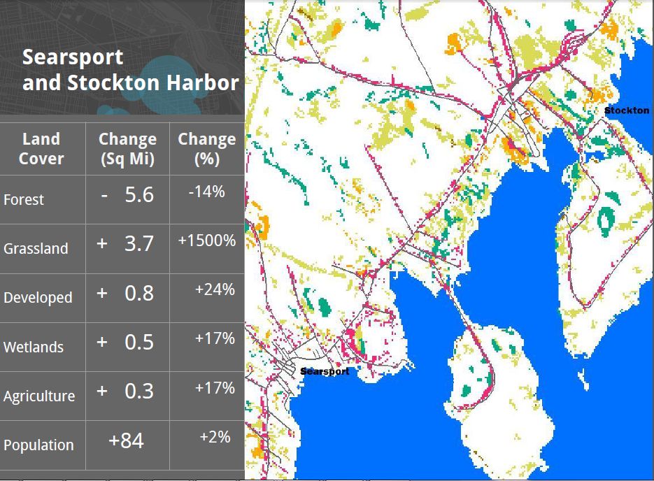
Stockton Springs & Searsport together lost 14%  of their forest cover: 5 and a half square miles. Population increase of 84 people since 1990.

White surfaces of map are unchanged More details here

=====================

Belfast  lost 4 square miles 15% of its forests. About 2 square miles became developed land.  While development went up 50%, the population only went up 4%.                      More details here

=================================

Increases in roads, buildings & parking lots from 1992 to 2011
Camden, Rockport Rockland Owls Head,  South Thomaston

DETAILS
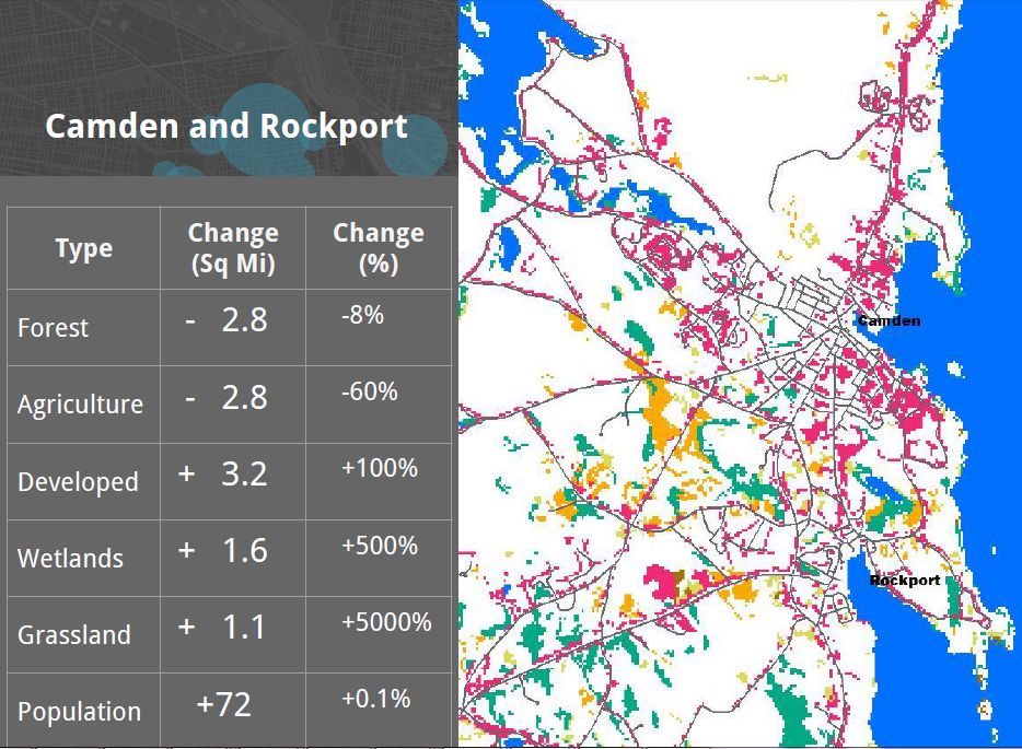
Camden & Rockport lost 8%  of their forestland.  3 square miles become developed land. 100% increase in development Lost almost 3 sq miles to development.    

Population grew by 72, or 0.1 percent   

White surfaces of map are unchanged

More details here


===========================================

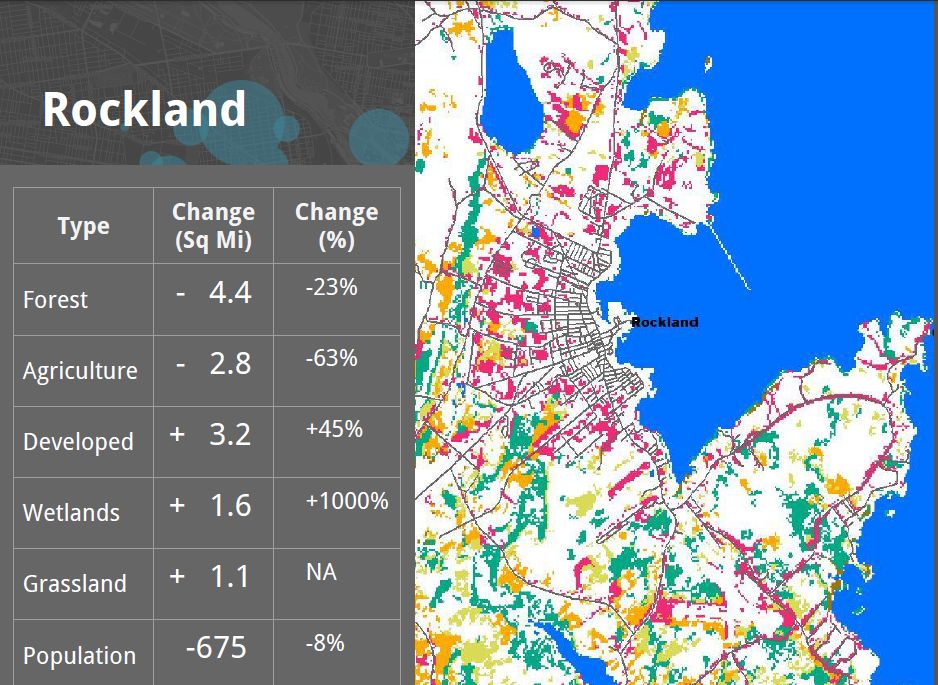
Rockland & SW Rockport lost 23% of their forest cover.  45% increase in developed land  Population  of the city dropped  8%, from 7,900 down to 7,200 between 1992 and 2011.

White surfaces of map are unchanged

More details here

===========================================

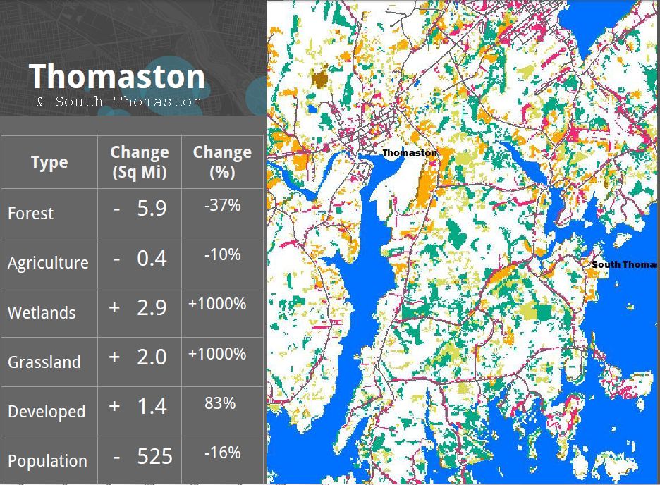
South Thomaston  lost 40% of its forests. 6 sq miles. 80% increase in develop 1994-2011.  An increase of 3 square miles of wetlands and 1 1/2 sq miles of developed land. 16% drop in  population; a decline of 500 people. 
 More details

===================================

The report was prepared by Kevin Frech, Azavea Intern, and recent Temple University graduate.


Aug 24, 2015

Second Battle of Penobscot Bay: Fierce fighting along the western bay corridor.

Struggle for the bay.
In the West: Wins, stalemates, losses.

Searsport, Belfast Rockport and Rockland are most in contention by Big Energy and Big Sprawl, or are in imminent risk of same. Let's go down the list 

Searsport.
WIN *GAC Chemical has vowed to, by the close of this year, remove acid wastes from their Stockton Harbor shore and create a neutralizing lime trench between the tainted slope and the intertidal beach below. This first serious response to our request - repeated on and off since 1998 - may markedly reduce the impact of Maine's worst ocean acidification source. In exchange GAC gains a "pollution pardon" for those particular deposits next to the abandoned acid plant. We'll give them a pat on the head, too.

LOSS * The Mack Point Wood is reeling from fragmentation caused when natural coastal forest and soils along its southwestern reach was replaced with acres of tarp and cable clad salt piles taller than the trees they replaced. by an enterprising landowner who deforested more than 15 acres.

LOSS * A shredded automobile export operation named Grimmel has gotten an annual town permit to operate. This having followed fast trackage by Maine DEP and DMR or their respective sign-offs on the project. There is now only the grim wait.

*IN PLAY State officials running the Searsport megadredge application have fast tracked it by rejecting an effort to have the Maine Board of Environmental Protection assume jurisdiction. The dreaded Patty Aho, via her subchief Suzanne "the Butcher" Miller of the eastern Maine DEP office, is certain to approve, and Islesboro will have to once again massively increase its cash burn rate to equip its Warriors of the Law with the litigatory weapons needed to combat both the LePage administration AND the Obama Administration.

Rockland

* Big Gas. IN PLAY The Carbonistan initiative from Boston to gas Rockland has been challenged but only slowed; a northern gas front is equally likely to open up the bay coast by way of Belfast. The Rockland site is a stone's throw from the city schools and athletic fields. It is even closer to the Little League Field.
A public information on the gas plant /pipeline proposal meeting was held. The gasser wannabees were not there, The public was, or course FORBIDDEN TO SPEAK, but could submit questions on little pieces of paper that had to pass through at least two censors before being aired. Mysteriously, few questions critical of the proposal made it to the moderator's microphone. Thus passeth democracy, one more razor cut to the body politic.

Belfast IN PLAY. Will Belfast save the bay by fending off a predicted northern gas invasion? (See rockland, below) Or will the Sprawl Army gas Belfast, then press south along the western Bay shore, linking up with a north expanding pipeline from Rockland? A pincer movement, spreading suburbanization and urbanization, and all their ecological disruptions in its wake? Belfast has a soul. Will it rise to the occasion. Time will tell.

Rockport
* WIN South coast forests of Clam Cove saved from subdivision by land sale to unidentified 1%ers for wooded family compound.

IN PLAY *Ecomapping of western Rockport Harbor from its coastal forests to its rocky submerged cliffs moves forward on two fronts:
(1) A snapshot comparison of the present with Rockport as documented in Beedy Parker's seminal 1984 book "A natural history of the Camden and Rockport area,covering weather patterns, geological composition of the land and the varieties of plant and animal life found here."

(2) IN PLAY A continuing log of marine and tidal and shallow subtidal observations of selected areas of the harbor using standard estuary documentation gear. Seasonally Identify the species mix of the present Rockport Harbor from several points.

Around the Bay. IN PLAY
No surer way to ruin the bay's rich ecosystem of microflora and microfauna in their shallow water haunts than by replacing the natural forests, swamps and meadows above them with asphalt and cement pavements, with roofs and chemlawns, transforming that tea into a poisonous iridescent technobrew called "stormwater".

Because that sort of gutting of the bay's coastal forests tends to take place in bites, it is important to preemptively document the existing environmental and ecological conditions of today's shoal ecosystems rimming the bay's coasts, from just below the tide to shoals edge edge of the shoal. This prior to their being impacted by tainted stormwater runoff.

PENOBSCOT BAY NEEDS YOU!   if you would like to help video document our bay's shallow water habitats call Ron at the Friends of Penobscot Bay at 207-593-2744 or email coastwtch@gmail.com

Or if you'd otherwise like to help take care of Maine's biggest bay and the wild atlantis below its surface! A bay is a terrible thing to waste.

Aug 3, 2015

Penobscot Bay sprawl trajectory 1940 to 2050 - according to the State of Maine

 Is this Penobscot Bay's growth trajectory? Rural to Suburban to Urban?
Doesn't bode well for lobsters! Scroll down below first image for larger sized growth maps.  Source Maine Coastal Program


May 22, 2014

Cabot Lyman hotel plan gets overwhelming NO from Rockland citizens at 5/20/14 hearing before Rockland planning board

Audio recordings from the 5/20/14 Rockland planning board meeting on Cabot Lyman's application to build a hotel at the intersection of  Main and Pleasant streets. Listen as people speak  eloquently or plainly in defense of their neighborhood against this shining example of "Dumb Growth"

1. Architect Pamela Hawkes (in process)  10 minutes

Oct 5, 2012

Penobscot Bay gets 'Friended'

A new environmental organization has risen to steward Penobscot Bay's water quality, fish and shellfish habitat and scenic resources. It held its first press conference October 4th 2012 on the Sears Island causeway. See TV coverage.

Why a new NGO? Aren't there enough already? Not..exactly.

For too long, Maine's biggest bay has suffered from a scattershot approach to protection of its natural resources from oil spills and other pollution sources and from inappropriate development.

Maine's newest marine conservation group, the Friends of Penobscot Bay, which held a media rollout of the organization on Thursday October 4, 2012 on the Sears Island causeway will bring expertise from around the bay and among the bay's fishery and tourism sectors to bear on these many local concerns.

Communities and citizens in the trenches defending their piece of Penobscot Bay
 from sprawl or pollution rarely have an opportunity to assist the bay's other defenders up and down her coast. Yet the problems raised by developers and waste dischargers around the bay are often very similar, often involving the same officials of the same agencies. The companies are represented by the same environmental consultants, law firms and public relations teams

The Friends of Penobscot Bay has come into being to respond to the need to coordinate such information. With a baywide organization run by fishermen and others whose living is dependent on their Bay having clean water and healthy marine and shoreline habitats, abundant prey and forage species, and high quality natural scenic beauty, the Friends are able to respond to any kind of issue, anywhere around the bay.

The vast majority of the bay's hatchling  fish and shellfish do not survive their first year before falling to predation, starvation or poor water quality. 


Unique among environmental groups the makeup of the Friends of Penobscot Bay's Board of Directors reflects its small business/ natural resource protection orientation: Sheila Dassatt of the Downeast Lobstermen's Association; Thomas Atherton of Bucksport, a commercial wormdigger and biologist; scalloper Michael Keating of Owls Head, workboat operator and diver Robert Izerbyt of Rockport, oyster farmer Jesse Stuart of Penobscot, recreational clammer and coastal camp operator Astrig Tanguay of Searsport, environmentalist Harlan McLaughlin, also of Searsport, and conservationist Ron Huber of Rockland
 
The Friends of Penobscot Bay  will inventory the knowledge and talents of the bay's many natural resource-reliant commercial businesses, from fishermen to wormdiggers to coastal campground operators and apply it  to each bay impacting development proposal, be it a summer home builder seeking to riprap an eroding shoreline or an energy giant.

Combining the local close-in citizens are critical for protection and improvement of our natural environment, bit by irreplaceable bit. However, the Friends of Penobscot Bay seek to boost the likelihood of bay-friendly outcomes in those efforts, by bringing  the combined  talents, knowledge, skills and assets of  the bay's fishermen, eco-defenders, and other bay users and enjoyers to bear on each local issue.

The bay is suffering from a thousand local cuts, inflicted over the last three hundred years. The combined effect is such that even small new development projects and waste sites can combine with dreadful effect on our bay's entire ecology.

An unhappy result of those 'thousand cuts' is that Penobscot Bay's finfish, mussels, scallops, seaworms, urchins and more are at historic low levels. Meanwhile many of the bay's irreplaceable scenic  and sonic viewsheds and other natural assets have been degraded by inappropriate coastal development, and many more are threatened. Lobstermen have reported a new  and stubborn skin disease infecting from even the minor cuts and abrasions that occur on the job.

While overfishing and inappropriate fishing tech are part of the poor fish stocks picture, has a rise in larval mortality of many bay fish and shellfish species added another stress to these animals?  

The vast majority of the bay's hatchling  fish and shellfish do not survive their first year before falling to predators, sometimes, as in the case of the cod, even their own species

BAY POLLUTION Under the guidance of that board,  the Friends of Penobscot Bay will take up the task of reducing water pollution and cleaning up the 100s of legacy toxic and petroleum waste dumps and spills that were created in the 19th and 20th centuries. They will also keep an eye on the bay's many operating outfalls, each of which has strict limitations on the discharges they are allowed to make into Penobscot Bay. 

BAY REPLENISHMENT The Friends of Penobscot Bay will attempt to redevelop and replenish the diversified fisheries and scenic wonders that, once overwhelmingly bountiful, have declined in many reaches of Penobscot Bay over the last 300 years.

Let's hope the Friends of Penobscot Bay accomplish what they are setting out to do!