Search

Showing posts with label Camden. Show all posts

May 13, 2022

Using Maine's moratorium process to slow the megapier sprawl boom in Penobscot Bay/lower River

2022  Bay and River town  Moratoria  on new Private  and Industrial Piers, Note in their "Whereas.."  sections the commonality of coastal towns  when caring for their local lands and waters.   They all follow a general format of wording

Successes and  and efforts underway 

CAMDEN    Accepted Voting in June

 PROSPECT       Moratoria successful 

LINCOLNVILLE  Moratorium accepted.   Vote:  failed

ROCKLAND  ( coming soon))

Camden Pier 2022 ballot question

 Camden's Ballot question 

Below is the Camden  Moratorium question , as image and as searchable text.
Below them is the list of Whereases the accompanies the question. It sums up the issues and reasons for the moratorium

Article 11.
Shall the town of Camden adopt a moratorium ordinance to prohibit installation, construction or modification of, docks, floats or ramps serving residential properties within the bounds of the Coastal Harbors District as defined in the harbor and waterways ordinance?  The term of the ordinance shall be for 180 days from the Effective Date. The Effective Date and date of applicability for the Outer and Coastal Harbor shall be by March 15th 2022, the  date of introduction of the Moratorium Ordinance discussion by the Camden Select Board. This Moratorium Ordinance shall not apply to any purpose for a pier and float system issued by the Select Board on or before March 15th 2022. This moratorium ordinance shall not apply to routine repairs or maintenance of existing piers, docks, floats or ramps located within the Outer or Coastal Harbor  

THE WHEREAS SECTION

CAMDEN MORATORIUM ORDINANCE

REGARDING RESIDENTIAL PIERS, DOCKS, FLOATS, RAMPS AND OTHER STRUCTURES IN CAMDEN’S OUTER AND COASTAL HARBORS

The TOWN OF CAMDEN, MAINE hereby adopts a Moratorium Ordinance as follows:

Whereas, Camden’s Outer and Coastal Harbors are valuable and unique natural, but limited, resources which are subject to increasing demands on the limited water area; and

Whereas, the Outer Harbor and Coastal Harbor are unexpectedly under threat of increased development pressure from structures, such as piers, docks, floats and ramps serving residential properties; and

Whereas, structures such as piers, docks, floats or ramps may have adverse impacts on the intertidal zone and ecosystem, and

Whereas, structures such as piers, docks, floats and ramps may adversely affect small recreational boating and access to a substantial degree, and

Whereas, structures such as piers, docks, float and floats may interfere with public access to and the use of the intertidal zone and harbor waters, and

Whereas, sea level rise is a significant threat to the Outer Harbor, Coastal Harbor, the shoreline, and structures such as piers, docks, floats and ramps; and

Whereas, as the Town’s Harbor Committee and Planning Board previously recommended changes to the Harbor and Waterways Ordinance; and

Whereas, the development of additional structures such as piers, docks and floats serving residential properties in the Outer Harbor and Coastal Harbor, pursuant to existing Zoning and Harbor and Waterways ordinance requirements, could pose serious harm to the public, the natural environment, abutting properties, mooring placement, recreational boaters and public access; and

Whereas, the development of additional residential structures such as piers, docks, floats and ramps floats in the Outer Harbor and Coastal Harbor may overburden public services, such as mooring placement and public access; and

Whereas, Town Ordinances do not adequately address the impacts and significance of sea level rise on these structures and the environment; and

Whereas the Town will need at least 180 days to develop and implement the necessary amendments to the Zoning and Harbor and Waterways Ordinances of the Town to adequately address this development pressure: and

Whereas, in the judgement of the Town, these facts create an emergency within the meaning of 30-A M.R.S section 4356 and require this Moratorium Ordinance as immediately necessary to prevent overburdening the Outer Harbor and Coastal Harbor, and to prevent serious harm; and

Now, therefore, it is hereby Resolved to adopt a Moratorium Ordinance to prohibit installation, construction or modification of structures such as, piers, docks, floats, or ramps serving residential properties within the bounds of the Outer Harbor and Coastal Harbor, as defined in the Camden Harbor and Waterways Ordinance. 

The term of this ordinance shall be for 180 days from the Effective Date. The Effective Date and date of applicability for the Outer Harbor shall be March 15, 2022, the date of introduction of the Moratorium Ordinance discussion by the Camden Select Board. The Effective Date and date of applicability for Coastal Harbor shall be March 21, 2022. 

This Moratorium Ordinance shall not apply to any permit for a pier and float system issued by the Select Board on or before March 15, 2022. This Moratorium Ordinance shall not apply to routine repairs or maintenance of existing piers, docks, floats or ramps located within the Outer Harbor or Coastal Harbor.

END OF WHEREAS

.

Jun 17, 2018

2018
A Likely Scenario During a Future Winter i New England.  
Examining a new report on Maine's power grid performance 
from December 24, 2017 to January 8, 2018.

2017
OPINION:The story of a windmill. By Dale Landrith Sr. | Jun 29, 2017

2015
AUDIO
September 22, 2015 selectboard discussion 
.  Is Camden Energy Committee being revived? 22 min mp3

July 28, 2015. Appointing new energy committee 11min mp3
July 14, 2015 Wind supporters critique opposition 18min mp3

VIDEOJuly 14, 2015 *&*July 28, 2015 Camden Selectboard meetings where forming a new Energy Committee came up:


WHO WE ARE ***MEETINGS & EVENTS
Want to get involved? Write us! ** Attend an Energy Committee meeting.
Reports *** Archive *** Ragged Mountain news
Ragged Mountain on the Web *** LINKS *** PHOTOS
EXISTING WIND ORDINANCES IN MAINE

Nov 16, 2016

Searsport Harbor dredge plans:two updates. Plus Camden & Blue Hill dredge news

Maine  Dredging Team Updates 
The Maine Dredging Team today released minutes from its October 11, 2016 meeting in Portland.  The team is led by Maine DOT  and the Army Corps of Engineers  and includes other state and federal agencies.  At the meeting, the Army Corps of  Engineers (ACOE)reviewed  the status of current navigation improvement projects in Maine. 
Below are sections from the report about Searsport Harbor,  Camden Harbor & Blue Hill Bay.  Read full 2 page report here. (pdf)  *** Meeting participants list (pdf)

Searsport Harbor (1). Ed O’Donnell (ACOE) explained that, at the request of MaineDOT, the ACOE is evaluating options for maintenance dredging of the existing federal project as a separate project, independent of the related proposed navigation improvement project. See above. Mr. O’Donnell clarified that the maintenance dredging project would be confined to the boundaries of the existing federal project, and involves dredging about 40,000 cy of material near the piers. Mr. O’Donnell further explained that ACOE is looking at various disposal options, would like to place the dredged material in a suitable upland location, and is awaiting further information from MaineDOT. 

Rob Elder (MaineDOT) noted that Maine DOT has retained an environmental consulting firm to investigate to assess upland disposal alternatives. In response to questions, 

Jay Clement (ACOE) indicated that he had no knowledge of discussions of potential dredging in the Penobscot River and placement of dredged materials in a CAD cell to be built off Castine and Cape Jellison as part of the federal court-ordered cleanup of mercury contamination. Mr. Clement said he’d check with colleagues and provide follow information. In response to the questions, Mr. Clement further explained that any such dredging and disposal project would require applicable state and federal permits, applications for which would be processed with public notice and opportunity for comment and in consultation with natural resources agencies. Mr. Clement further explained that a project-specific EA would prepared and would be the basis for determining whether an EIS would be appropriate to ensure a hard look at environmental effects.

Searsport Harbor (2) Ed O’Donnell (ACOE) explained that, at the request of MaineDOT, the ACOE is evaluating options for maintenance dredging of the existing federal project as a separate project, independent of the related proposed navigation improvement project. See above.
Searsport Harbor. Mack Point dredging, 1966.

Ed O’Donnell clarified that the maintenance dredging project would be confined to the boundaries of the existing federal project, and involves dredging about 40,000 cy of material near the piers. Mr. O’Donnell further explained that ACOE is looking at various disposal options, would like to place the dredged material in a suitable upland location, and is awaiting further information from MaineDOT.   Rob Elder (MDOT)noted that MaineDOT has retained an environmental consulting firm to investigate to assess upland disposal alternatives.

In response to questions, Jay Clement (ACOE) indicated that he had no knowledge of discussions of potential dredging in the Penobscot River and placement of dredged materials in a CAD cell to be built off Castine and Cape Jellison as part of the federal court-ordered cleanup of mercury contamination.  Mr. Clement said he’d check with colleagues and provide follow information. In response to the questions, Mr. Clement further explained that any such dredging and disposal project would require applicable state and federal permits, applications for which would be processed with public notice and opportunity for comment and in consultation with natural resources agencies. Mr. Clement further explained that a project-specific EA would prepared and would be the basis for determining whether an EIS would be appropriate to ensure a hard look at environmental effects.

Camden Harbor .  Mark Habel (ACOE) reported that ACOE headquarters approved federal involvement in a feasibility study of a proposal to improve the existing breakwater. Work on this project remains on-hold pending execution of a feasibility cost-sharing agreement with the Town of Camden pursuant to which the town would be obligated to fund 50% of the study’s cost.  The ACOE awaits the Town’s decision.  Note This project has been "on hold" since at least May, 2016.      Camden Harbor Navigation Project

Blue Hill Bay. Mark Habel (ACOE) said that the Town of Blue Hill and the ACOE have entered into a cooperative agreement for the on-going feasibility study for this project. which involves a proposed shallow-draft channel and turning basin. See news story.10/20/16 Environmental sampling showed gasoline contamination in some areas where dredging had been planned, and additional sampling showed this to be confined to surface sediments, with clean glacial till comprising the bulk of the material to be dredged. The ACOE and town are also looking at reconfiguring the turning basin to minimize the volume of contaminated material needing removal.

Oct 11, 2015

West Penobscot Bay: Substantial coastal forest losses since early1990s: report

"Substantial deforestation" in all West Penobscot Bay towns between 1992 and 2011.  
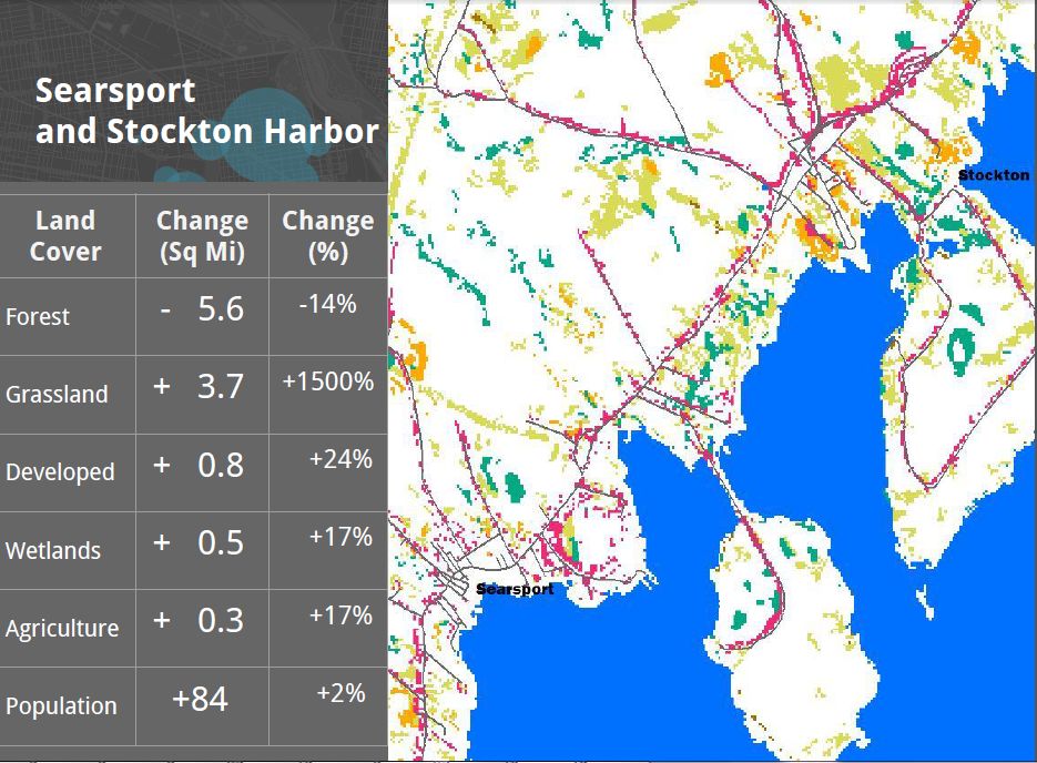
Summary According to a report prepared earlier  August 17, 2015 for Friends of  Penobscot Bay, western bay towns Stockton Springs, Searsport, Belfast, Camden, Rockport, Rockland and South Thomaston lost about 30 square miles of forests between 1992 and 2011.

Full slideshow  as PDF and as powerpoint *** Listen to 8/17/15 presentation on this report

Twelve square miles of those lost forests became impervious surfaces, e.g. buildings, roads, parking lots. The remainder has become either wetlands or grasslands.  
Surprisingly with this 85% increase in developed land, came an average decline of 2% in west Penobscot Bay town populations.                                          
===============================

The report "Tools for Assessing and Managing Human Impact on Maine’s Harbors" was prepared by Kevin Frech, in cooperation with Public Laboratory

Funding for the study was provided  by the Azavea Foundationdedicated to improving data access and usage in natural resource and social applications 

  
===============================

 Forest cover changes, Stockton Springs to South Thomaston, 1992 - 2011

Stockton Springs & Searsport together lost 14%  of their forest cover: 5 and a half square miles. Population increase of 84 people since 1990.

White surfaces of map are unchanged More details here

=====================

Belfast  lost 4 square miles 15% of its forests. About 2 square miles became developed land.  While development went up 50%, the population only went up 4%.                      More details here

=================================

Increases in roads, buildings & parking lots from 1992 to 2011
Camden, Rockport Rockland Owls Head,  South Thomaston

DETAILS
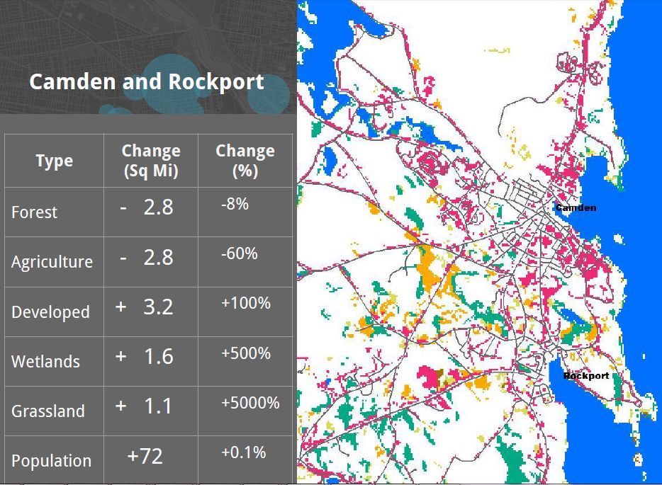
Camden & Rockport lost 8%  of their forestland.  3 square miles become developed land. 100% increase in development Lost almost 3 sq miles to development.    

Population grew by 72, or 0.1 percent   

White surfaces of map are unchanged

More details here


===========================================

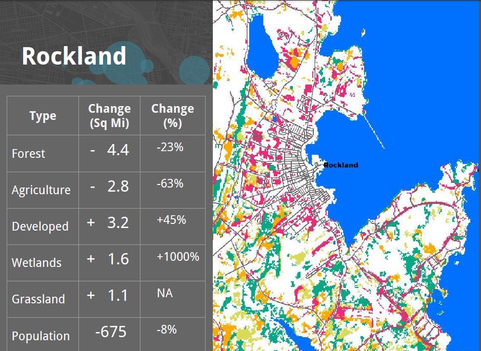
Rockland & SW Rockport lost 23% of their forest cover.  45% increase in developed land  Population  of the city dropped  8%, from 7,900 down to 7,200 between 1992 and 2011.

White surfaces of map are unchanged

More details here

===========================================

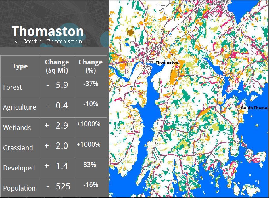
South Thomaston  lost 40% of its forests. 6 sq miles. 80% increase in develop 1994-2011.  An increase of 3 square miles of wetlands and 1 1/2 sq miles of developed land. 16% drop in  population; a decline of 500 people. 
 More details

===================================

The report was prepared by Kevin Frech, Azavea Intern, and recent Temple University graduate.


Sep 16, 2015

FOAA responses of Rockland officials re Gas Plant plan September 2015

 On September 4, 2015, Friends of Penobscot Bay filed a freedom of access act request with  six members of the Rockland City government. We asked for  documents  "from between July 28 2015 and September 4, 2015, inclusive, that pertain to the proposed natural gas cogeneration power plant  and pipeline proposals being considered In or connecting to Rockland" .

City Council member Larry Pritchett 150 pages  
*   Pritchett's response broken into six 25 page parts

Audra Caler Bell, Economic Development Dir 19 pages

* Kevin Beal City Attorney 14 pages

* James Chaousis City Manager 142 pages 

* City Mayor Frank Isganitis 37 pages 

* City treatment Plant Operator Terry Pinto 1page 


May 12, 2013

Licensed dischargers into Penobscot Bay. Licenses and enforcement histories

Licensed dischargers into Penobscot Bay & enforcement histories

Saint George (Atlantic Ocean


East Wind Incorporated (PDF) (2 pp, 2MB)


ME0036773


07/18/2011
Saint George (Long Cove)Sea Hag Seafood, Inc. (PDF) (34 pp, 2.2MB) EnforcementME003734610/03/2012


St. George (Long Cove)Great Eastern Mussel Farms, Inc. 
Now: Sea Hag (PDF)(42 pp, 2.1MB) Enforcement
ME002312411/08/2007


Owls Head (Atlantic Ocean)Crescent Beach Association (PDF) (40 pp, 2.8MB) EnforcementME003678111/30/2010
Owls Head (Atlantic Ocean)Crescent Beach Association (PDF) (30 pp, 1.3MB)ME003678111/29/2005


Rockland (Atlantic Ocean)Rockland POTW, City of (PDF) (25 pp, 216K)  EnforcementME010059511/21/2009
Rockland (Atlantic Ocean)Rockland POTW, City of (PDF) (84 pp, 229K)ME010059512/21/2007
Rockland (Rockland Harbor)FMC Biopolymer (PDF) (40 pp, 2.7MB) EnforcementME000040012/04/2012
Rockland (Rockland Harbor)FMC Biopolymer (PDF) (31 pp, 1.6MB)ME000040010/09/2007
Rockland (Rockland Harbor)Rockland POTW, City of (PDF) (13 pp, 102K) EnforcementME010059501/31/2008
Rockland (Rockland Harbor)Rockland, City of; Waste Snow Dump (PDF) (29 pp, 2MB)ME003632304/12/2012
Rockland (Rockland Harbor)Rockland, City of; Waste Snow Dump (PDF) (15 pp, 817K)ME003632312/28/2006
Rockland (Rockland Pier)Dragon Products Company, LLC (PDF)(16 pp, 45K) EnforcementME003699411/25/2008
Rockport (Rockport Harbor)Rockport Waste snowdump (PDF) (16 pp, 649K) EnforcementME003630710/03/2006


Camden (Camden Harbor Watershed)Camden, Town of (PDF) (32 pp, 3MB)  Enforcement

ME010013707/18/2003
Camden (Camden Harbor)Camden Waste Snow Dump, Town of (PDF) (29 pp, 1.2MB) EnforcementME010272508/05/2010
Camden (Megunticook River)

Camden Waste Snow Dump, Town of (PDF) (13 pp, 643K)ME010272510/28/2005


Vinalhaven (Atlantic Ocean)Vinalhaven POTW, Town of (PDF) (61 pp, 4.1MB) EnforcementME010249111/02/2012
Vinalhaven (Atlantic Ocean)Vinalhaven POTW, Town of (PDF) (49 pp, 2.1MB)ME010249111/1


North Haven (Fresh Pond)North Haven DWTP, Town of (PDF) (34 pp, 1.1MB) EnforcementME010248208/02/2012
North Haven (Fresh Pond)North Haven DWTP, Town of (PDF) (22 pp, 1.1MB)


Islesboro (East Penobscot Bay)Islesboro, Town of (PDF) (11 pp, 1.8MB)ME010026901/20/2012
Islesboro (East Penobscot Bay)Islesboro, Town of (PDF) (25 pp, 1.3MB)ME010026911/21/2005
Enforcement

Lncolnville Beach
Lincolnville Beach Sanitary Facility  Enforcement history

Northport Village Corp  Enforcement info
NorthportAtlantic Blanket Company (PDF) (33 pp, 2.3MB) Enforcement infoMEU50825712/02/2010


BelfastMoore’s Septic, Inc. (PDF) (40 pp, 3.2MB)  Enforcement infoMEU50825910/03/2012
Belfast (Atlantic Ocean, Belfast Harbor)Belfast POTW, City of (PDF) (81 pp, 3.2MB)
Enforcement info
ME010153202/18/2011
Belfast (Belfast Harbor)Belfast POTW, City of (PDF) (5 pp, 24K)ME010153202/12/2008
Belfast (Belfast Harbor)Belfast POTW, City of (PDF) (64 pp, 3MB)ME010153205/23/2006
Belfast (Passagassawakeag River)Penobscot McCrum, LLC (PDF) (72 pp, 4.7MB)ME002304312/04/2012
Belfast (Passagassawakeag River)Penobscot Mccrum, LLC (PDF) (64 pp, 2.5MB)
Enforcement info
ME002304310/17/2007


Searsport (Atlantic Ocean/Stockton Harbor)General Alum New England Corporation Chemical Manufacturing Facility 2006 (PDF) (42 pp, 3MB) Enforcement info
TRI Discharges

ME000183003/03/2011

Searsport (Long Cove, Penobscot Bay)
Irving Oil Terminals, Inc. (PDF) (75 pp, 2.3MB) Enforcement infoME000246104/09/2010
Searsport (Penobscot Bay)Searsport, Town of (PDF) (79 pp, 1.4MB) Enforcement infoME010196611/12/2008
Searsport (Searsport Harbor)Irving Oil Terminals, Inc. (PDF) (70 pp, 2.2MB)
Enforcement info  TRI Info
ME002118104/09/2010
Searsport (Searsport Tidewaters)Sprague Energy Corporation (PDF) (73 pp, 14.3MB) Enforcement infoME000220809/14/2009
Searsport (Searsport)Sprague Energy Corporation (PDF) (27 pp, 1.3MB) TRI InfoME000220812/15/2006


Winterport (Penobscot River)Winterport Water District (PDF) (61 pp, 3.6MB) Enforcement  infoME0100


Hampden (Penobscot River)Coldbrook Energy, Inc. (PDF) (50 pp, 2.2MB)
Enforcement info
ME000226712/20/2011
Hampden (Penobscot River)Coldbrook Energy, Inc. (PDF) (31 pp, 1.4MB)ME000226711/06/2006
Hampden (Souadabscook Stream)Hampden CSO, Town of (PDF) (34 pp, 2.1MB)
Enforcement info
ME010251202/04/2013
Hampden (Souadabscook Stream)Hampden CSO, Town of (PDF) (52 pp, 1.7MB)ME010251201/07/2008


Bangor (Penobscot River)Webber Oil Company Bulk Fuel Storage Facility (PDF) (43 pp, 2.2MB)ME002222505/19/2010
Bangor (Penobscot River)Webber Oil Company (PDF) (28 pp, 1.5MB)
Enforcement info
ME002222504/25/2006
Bangor (Penobscot River, Kenduskeag Stream )Bangor POTW (PDF) (135 pp, 4.4MB)

Enforcement info
ME010078105/26/2011


BucksportBucksport, Town of (PDF) (65 pp, 4.1MB) Enforcement infoME010011104/10/2012
BucksportVerso Bucksport LLC (PDF) (23 pp, 1.4MB)  Enforcement InformationME000216006/07/2012
BucksportVerso Bucksport LLC (PDF) (22 pp, 1.8MB)ME000216009/02/2010
Bucksport (Penobscot River)Verso Bucksport LLC (PDF) (65 pp, 3.3MB)ME000216001/07/2010
Bucksport (Penobscot River)Webber Tanks, Inc. Bulk Fuel Storage Facility (PDF) (68 pp, 16.1MB)ME000145710/15/2010
Bucksport (Penobscot River)Webber Tanks, Inc. Bulk Fuel Storage Facility (PDF) (28 pp, 1.3MB)ME000145704/25/2006


Orrington (Penobscot River)Penobscot Energy Recovery Co. (PDF)(67 pp, 2.6MB) 
Enforcement info

ME002323008/26/2009


Brewer (Penobscot River)Brewer POTW (PDF) (111 pp, 2.7MB)ME010007205/19/2011
Brewer (Penobscot River)Brewer POTW (PDF) (34 pp, 933K) | Fact Sheet (PDF) (16 pp, 297K)ME010007204/25/2003
Brewer (Penobscot River)CES Inc. (PDF) (16 pp, 742K)ME010269511/04/2005

Brewer POTW Enforcement
OrlandG.M. Allen & Son, Inc. Surface Wastewater Disposal System (PDF) (42 pp, 2.1MB)MEU50779112/22/2009
OrlandLetts Relax, Inc. (PDF) (35 pp, 1.55MB)MEU50787408/13/2007
Orland (Alamoosook Lake)Craig Brook National Fish Hatchery (PDF) (8 pp, 544K)ME000243702/04/2013
Orland (Alamoosook Lake)Craig Brook National Fish Hatchery (PDF) (23 pp, 1.9MB)ME000243705/16/2011
Orland (Alamoosook Lake)Craig Brook National Fish Hatchery (PDF) (73 pp, 2.9MB)ME000243702/02/2010


Penobscot (Penobscot River)School Union 93 (PDF) (21 pp, 71K)ME010197408/28/2008
Penobscot Nursing Home 


CastineCastine POTW, Town of (PDF) (15 pp, 55K)ME010119203/12/2008
Castine (Castine Harbor)Castine POTW, Town of (PDF) (77 pp, 2.3MB)ME010119212/29/2009
Castine enforcement reports


<area shape="circ" coords="104,579" href="http://www.epa-echo.gov/cgi-bin/get1cReport.cgi?tool=echo&IDNumber=110046118278" target="_BLANK">