DEP's
2. EXISTING SCENIC, AESTHETIC, RECREATIONAL OR NAVIGATIONAL USES:
The NRPA, in 38 M.R.S. § 480-D(1), requires the applicant to demonstrate that the
proposed project will not unreasonably interfere with existing scenic, aesthetic,
recreational and navigational uses.
A. Scenic and Aesthetic Uses: In accordance with Chapter 315, Assessing and
Mitigating Impacts to Scenic and Aesthetic Uses (06-096 C.M.R. ch. 315, effective June
29, 2003), the applicant submitted a copy of the Department's Visual Evaluation Field
Survey Checklist as Appendix A to the application along with a description of the
property and the proposed project. The applicant also submitted several photographs of
the proposed project site and surroundings. Department staff visited the project site on
November 5, 2021.
The proposed project is located in Rockland Harbor, which is a scenic resource visited by
the general public, in part, for the use, observation, enjoyment and appreciation of its
natural and cultural visual qualities. The project site is located adjacent to Sandy Beach
(also known as South End Beach), a 200-foot-long municipal beach. The project parcel
contains a paved walkway that is part of the Harbor Walk, a system of paths on multiple
public and privately-owned, waterfront properties that connects several public spaces and
viewpoints along the shoreline including Sandy Beach, Harbor Park, and Buoy Park, all
of which are located within 0.2 miles of the project site, and all of which meet the
Chapter 315 definition of a scenic resource of local significance. The project site is
located approximately 1.35 miles from the Breakwater and the Breakwater Lighthouse,
both of which are listed on the National Register of Historic Places as areas of local
L-20386-4P-P-N/L-20386-4E-Q-N 5 of 20
significance. The harbor is developed with two municipal piers, a coast guard station,
and numerous commercial piers and buildings, including the applicant’s existing pier,
which are visible from the scenic resources listed above.
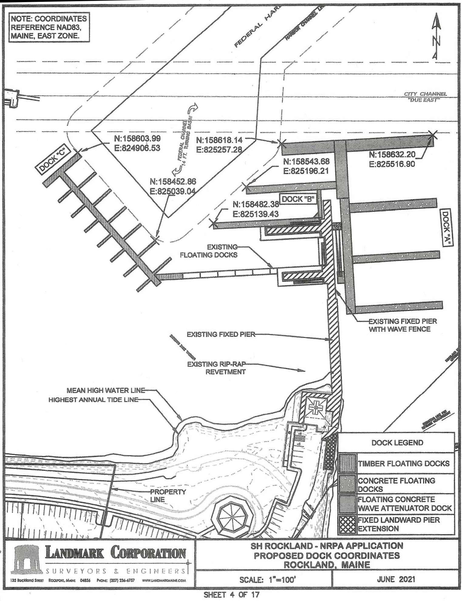
To reduce the visibility of the proposed project from the harbor and nearby scenic
viewpoints, the applicant designed the expanded marina with materials similar to those of
other commercial piers in the immediate area. In response to public feedback during
project design, the applicant reduced the size of the proposed float system and redesigned
the layout to avoid vessels being berthed broadside to viewpoints to the west, including
Buoy Park, a municipal pier (the Public Landing), and the boardwalk portion of the
Harbor Walk.
The applicant reduced the proposed landward extension of the fixed pier, eliminating a proposed vehicle and crane access platform for servicing boats. The applicant also eliminated the need for an additional timber wave fence to the east by designing the proposed floats of Dock A to be concrete-encased wave-attenuating floats.
In their comments, many of the interested persons expressed concern that the applicant
will revoke public access to the Harbor Walk on their property and that large vessels
berthed at the marina will block views of or from the scenic features listed above.
Herein, “large vessel” refers to a vessel greater than 70 feet in length. A subset of
commenters expressed concerns about light pollution at night and the visual impact of
tour buses, which could be chartered by marina patrons for transportation to nearby
points of interest, parked in the upland near Sandy Beach. A number of commenters also
raised concerns about noise from electric generators of vessels berthed at the expanded
marina.
The Department provided a consolidated list of these comments to the applicant and
requested a response. In its response, the applicant stated that the portion of the Harbor
Walk on its property will remain open to the public, and that the applicant will work with
the City to create a formal agreement for continued public access to the walkway. The
applicant also responded that the proposed landward extension of the pier will be open to
the public, and that the existing gate on the pier will be moved seaward, such that the
proposed project will provide a 120-foot-long viewing platform open to the public, with
views to the east beyond the expanded marina.
The applicant stated that the size of the vessels that will use the expanded marina is
expected to range from 20 feet to 200 feet long, but the majority of the vessels berthed at
the marina will continue to range from 30 to 60 feet long. The applicant stated that the
vertical height of most large vessels that may use the pier is approximately 25 feet above
the water, or 7.5 to 17.5 feet above the height of the existing fixed pier, depending on the
tide. The applicant noted that the proposed project is primarily for transient dockage,
defined as a stay no longer than 15 consecutive days, and that the average size vessel at
the marina during the summer of 2020 was approximately 56 feet long, and the average
stay of a vessel over 70 feet long was only 2.6 days.
In their comments, many of the interested persons expressed concern that the applicant
will revoke public access to the Harbor Walk on their property and that large vessels
berthed at the marina will block views of or from the scenic features listed above.
Herein, “large vessel” refers to a vessel greater than 70 feet in length. A subset of
commenters expressed concerns about light pollution at night and the visual impact of
tour buses, which could be chartered by marina patrons for transportation to nearby
points of interest, parked in the upland near Sandy Beach. A number of commenters also
raised concerns about noise from electric generators of vessels berthed at the expanded
marina.
The Department provided a consolidated list of these comments to the applicant and
requested a response. In its response, the applicant stated that the portion of the Harbor
Walk on its property will remain open to the public, and that the applicant will work with
the City to create a formal agreement for continued public access to the walkway. The
applicant also responded that the proposed landward extension of the pier will be open to
the public, and that the existing gate on the pier will be moved seaward, such that the
proposed project will provide a 120-foot-long viewing platform open to the public, with
views to the east beyond the expanded marina.
The applicant stated that the size of the vessels that will use the expanded marina is
expected to range from 20 feet to 200 feet long, but the majority of the vessels berthed at
the marina will continue to range from 30 to 60 feet long. The applicant stated that the
vertical height of most large vessels that may use the pier is approximately 25 feet above
the water, or 7.5 to 17.5 feet above the height of the existing fixed pier, depending on the
tide. The applicant noted that the proposed project is primarily for transient dockage,
defined as a stay no longer than 15 consecutive days, and that the average size vessel at
the marina during the summer of 2020 was approximately 56 feet long, and the average
stay of a vessel over 70 feet long was only 2.6 days.
The proposed Dock C, located innermost in the harbor, will be dedicated to vessels approximately 30-40 feet in length, whereas large vessels will be located farther from the Harbor Walk at Docks A or B. The applicant noted that a similar version of Dock C was previously approved in Department
Order #L-20386-26-G-B/L-20386-4E-H-N, although it was not constructed, and that
previous approved versions of Dock A extended farther seaward than the proposed
project. The applicant pointed out that large vessels already use the harbor, and
submitted a photograph dated June 2019, of a 200-foot-long cruise ship berthed at the
Public Landing, facing broadside to Harbor Park. The applicant stated that currently,
cruise ships and other large vessels often anchor in the outer harbor, where they can block
views of many of the scenic features noted above, such as the Breakwater and
Breakwater Lighthouse, whereas vessels berthed at the expanded marina will have a more
limited visual impact, primarily only affecting views of existing developed areas in the
harbor such as other commercial marinas, the Municipal Fish Pier, and the Dragon
Cement pier. The applicant concluded that the proposed project would have minimal
impact on views of significant scenic features.
The applicant stated that the expansion will use lighting similar to that of the existing
pier, which consists of lighting of the dock walking surface and potentially low-voltage
lighting directed at the floats. The Department determined that this lighting is compatible
with the existing visual landscape of the harbor at night. The applicant stated that the
proposed dock systems will include electrical hook-ups for small and large vessels, and
therefore the proposed project will not result in additional noise from onboard generators.
The applicant further stated that accommodations for buses are not contemplated in this
application, and any upland alterations to accommodate buses would require review and
approval by the Department in a future application. The Department acknowledges that
buses could potentially use the existing parking lot and nearby side streets, if allowed by
local ordinance to do so. However, the Department determined that this activity is
ultimately outside the scope of the Department’s review.
In assessing the visual impact of the proposed project, the Department considered the
information in the NRPA application, the interested persons’ comments, the applicant’s
responses, observations by Department staff at the site visit, and other related materials
on file. Some commenters stated that the applicant should provide a visual assessment
report with photographic simulations or concept drawings; however, the Department
determined that the information in the permitting record is sufficient for the Department’s
review.
Order #L-20386-26-G-B/L-20386-4E-H-N, although it was not constructed, and that
previous approved versions of Dock A extended farther seaward than the proposed
project. The applicant pointed out that large vessels already use the harbor, and
submitted a photograph dated June 2019, of a 200-foot-long cruise ship berthed at the
Public Landing, facing broadside to Harbor Park. The applicant stated that currently,
cruise ships and other large vessels often anchor in the outer harbor, where they can block
views of many of the scenic features noted above, such as the Breakwater and
Breakwater Lighthouse, whereas vessels berthed at the expanded marina will have a more
limited visual impact, primarily only affecting views of existing developed areas in the
harbor such as other commercial marinas, the Municipal Fish Pier, and the Dragon
Cement pier. The applicant concluded that the proposed project would have minimal
impact on views of significant scenic features.
The applicant stated that the expansion will use lighting similar to that of the existing
pier, which consists of lighting of the dock walking surface and potentially low-voltage
lighting directed at the floats. The Department determined that this lighting is compatible
with the existing visual landscape of the harbor at night. The applicant stated that the
proposed dock systems will include electrical hook-ups for small and large vessels, and
therefore the proposed project will not result in additional noise from onboard generators.
The applicant further stated that accommodations for buses are not contemplated in this
application, and any upland alterations to accommodate buses would require review and
approval by the Department in a future application. The Department acknowledges that
buses could potentially use the existing parking lot and nearby side streets, if allowed by
local ordinance to do so. However, the Department determined that this activity is
ultimately outside the scope of the Department’s review.
In assessing the visual impact of the proposed project, the Department considered the
information in the NRPA application, the interested persons’ comments, the applicant’s
responses, observations by Department staff at the site visit, and other related materials
on file. Some commenters stated that the applicant should provide a visual assessment
report with photographic simulations or concept drawings; however, the Department
determined that the information in the permitting record is sufficient for the Department’s
review.
During the review, the Department considered views from Rockland Harbor, the
Harbor Walk, Sandy Beach, Harbor Park, and Buoy Park, which are located in close
proximity to the project site and were of particular concern to the interested persons.
Harbor Walk, Sandy Beach, Harbor Park, and Buoy Park, which are located in close
proximity to the project site and were of particular concern to the interested persons.
The Department took into consideration the developed nature of Rockland Harbor, the size
and layout of the proposed marina expansion, and the existing viewsheds from the scenic
resources.
and layout of the proposed marina expansion, and the existing viewsheds from the scenic
resources.
The Department determined that the viewshed foreground of the Harbor Walk, Harbor Park,
and Buoy Park are dominated by existing pier and float systems,
some of which currently berth large vessels during the summer.
some of which currently berth large vessels during the summer.
Sandy Beach, which faces northeast, has a viewshed of 120 degrees, bounded to the southeast by the Dragon Cement pier and bounded to the north by the applicant’s existing pier.
Department staff determined that the proposed expansion of the marina will affect approximately
17 degrees of the far west extent of the beach viewshed. The blocked views include other
commercial marinas to the north as well as a small portion of the harbor mooring field.
The proposed project will not interfere with views from the beach of the Breakwater,
Breakwater Lighthouse, islands, or other land masses to the east.
17 degrees of the far west extent of the beach viewshed. The blocked views include other
commercial marinas to the north as well as a small portion of the harbor mooring field.
The proposed project will not interfere with views from the beach of the Breakwater,
Breakwater Lighthouse, islands, or other land masses to the east.
Department staff also considered the potential view of the proposed project from the Breakwater and visited the landward end of the Breakwater on November 5, 2021; however, given the distance to the
project site and the highly developed nature of the harbor, the Department determined
that the proposed project will be consistent with the existing use of the harbor and will
result in little to no additional impact on views from the Breakwater.
The Department staff utilized the Department’s Visual Impact Assessment Matrix in its
evaluation of the proposed project. The Matrix is used to assess the visual impact
severity of a proposed project based on the distance and visibility of the project from a
natural landmark or other outstanding natural or cultural feature, State, National, or
locally-designated park or trail, and on the approximate number of people likely to view
the project from the resource or a public way per day.
project site and the highly developed nature of the harbor, the Department determined
that the proposed project will be consistent with the existing use of the harbor and will
result in little to no additional impact on views from the Breakwater.
The Department staff utilized the Department’s Visual Impact Assessment Matrix in its
evaluation of the proposed project. The Matrix is used to assess the visual impact
severity of a proposed project based on the distance and visibility of the project from a
natural landmark or other outstanding natural or cultural feature, State, National, or
locally-designated park or trail, and on the approximate number of people likely to view
the project from the resource or a public way per day.
The severity rating is also based on the visual elements of landscape compatibility, scale
contrast, and spatial dominance as defined in Chapter 315, § 9.
The Department determined that the visual impact of the proposed project was acceptable with mitigation. As discussed above, the applicant reduced the size and revised the layout of the proposed project considerably during the design phase, in response to concerns about visual impact. The applicant also proposes to create a public viewing platform and to maintain public access to the Harbor Walk over its private property.
In light of these mitigation measures and based on the information submitted in the application, information submitted during the review, the visual impact rating, and the site visit, the Department determined that the location and scale of the proposed activity is compatible with the existing visual quality and landscape characteristics found within the viewshed of the scenic resources in the project area.