Search

May 15, 2008

Sears Island: Why EPA said NO to a port back in the 90s

And why NO is still the right answer. Nothing has changed since then...

On September 29, 1995, John Devillars of US EPA New England wrote to the Federal Highway Administration and to the U. S. Army Corps of Engineers about the proposed Sears Island cargo port. Below is the introduction, then the "environmental impacts" section of his letter. (Full letter.)

Dear Mr. Lariviere and Colonel Bradbury:

I am pleased to provide the Environmental Protection Agency's comments on the Draft Supplemental Environmental Impact Statement for the Maine Department of Transportation's proposal to construct a marine dry cargo terminal on Sears Island in Penobscot Bay. Our comments are in accordance with our responsibilities under three federal environmental laws -- the National Environmental Policy Act, the Clean Air Act, and the Clean Water Act.

Introduction

The Maine Department of Transportation seeks to build a modern, expandable marine cargo terminal on Sears Island, located at Searsport, Maine in Penobscot Bay. For over a decade, Maine has identified this project as one of great importance to the long term economic vitality of the State. At the same time, there are extremely valuable environmental resources at stake. Because of the severity of the environmental harm it would cause, as discussed below, the project as currently proposed cannot receive a Clean Water Act § 404 permit unless it is modified to reduce the impacts through further avoidance and/or development of a mitigation package which would sufficiently compensate for these impacts.

The challenge that lies ahead is to identify practicable ways to further avoid and compensate for the environmental losses so that Maine Department of Transportation can proceed to construct a cargo terminal in mid-coast Maine in an environmentally acceptable manner.

Environmental Impacts

"In evaluating the adverse impacts of this project, I have carefully reviewed the record before me including extensive analysis conducted by EPA marine and wetland biologists, the professional
staff of both the U. S. Fish and Wildlife Service and the National Marine Fisheries Service, and numerous informed commenters who have reviewed the DSEIS. Based on that review, I conclude that the impacts on eelgrass, intertidal and subtidal habitat, clamflats, forested wetlands, vernal pools, and streams associated with the Sears Island cargo facility, as currently proposed, are environmentally objectionable, and would cause significant degradation to the aquatic environment.

"This judgment is unequivocally endorsed by both the U. S. Fish and Wildlife Service and the National Marine Fisheries Service.

"A. Sears Island Alternatives
"The substantial impacts to both marine and freshwater habitats associated with the twelve Sears Island alternatives portrayed in the DSEIS would cause significant degradation to waters of the United States in violation of Section 230.10(c) of the 404(b)(1) guidelines and may result in substantial and unacceptable adverse impacts to aquatic resources of national importance.

The most environmentally damaging impacts associated with the twelve alternatives identified for analysis by MDOT are:

"* Permanent loss of a minimum of 13 acres of highly productive eelgrass beds, and the reduced productivity of up to an additional 80 to 250 acres of eelgrass. Eelgrass loss of this magnitude is unprecedented in New England. To our knowledge, no projects have ever been permitted that have approached this amount of destruction and degradation to submerged aquatic vegetation.

"* Permanent destruction of roughly 16 acres of intertidal habitat. These areas provide habitat for commercially and recreationally important species, including soft-shell clams, mussels, Atlantic salmon, menhaden, winter flounder, and other finfish species. The environmental values of this marine habitat has been recognized by the National Marine Fisheries Service and the U.S. Fish and Wildlife Service. Moreover, the State of Maine has classified this area as habitat of regional significance to coastal wildlife, and MDOT's own consultant has documented the extremely high productivity of these marine habitats.

"* Fill or pilings placed in a minimum of 12 acres of subtidal habitat. These subtidal areas provide habitat for lobsters, crabs, sea urchins, numerous finfish species, and grey and harbor seals. An additional 34 to 46 acres of subtidal area would be dredged, resulting in a loss of foraging habitat and food resources for lobsters, crabs, sea urchins, grey and harbor seals, menhaden, Atlantic silversides, and other migratory finfish.

"* Outright destruction and total loss of functions of at least 17 acres of freshwater wetlands, up to four vernal pools and almost two-thirds of a mile of stream. Extensive indirect effects would render many of the adjacent wetlands on Sears Island less suitable or uninhabitable by wildlife. These direct and indirect effects would irreparably alter the integrity of this high quality, undisturbed ecosystem. If permitted as proposed, the impacts to freshwater wetlands and waters would be one of the most damaging to wildlife habitat in Maine in the past decade.

"In addition, the proximity of extremely valuable freshwater wetlands, vernal pools, mudflats, saltmarshes, eelgrass beds, and intertidal areas found on Sears Island is unusual. The juxtaposition of these valuable habitats results in a high biodiversity of wildlife species utilizing the island: more than three quarters of all wetland 'dependent mammal species and wetland dependent bird species occurring in this region of Maine have been verified on Sears Island. Construction of the project as proposed would result in substantial loss of ecological diversity, productivity, and stability for these species, and would adversely affect habitat for numerous species considered imperiled by the State, including the bald eagle and the peregrine falcon.

"EPA believes that the marine impacts are by themselves significant. The Sears Island marine habitats are exceptionally diverse, productive, and valuable to the fisheries resources of both Penobscot Bay and Penobscot River. As noted above, EPA is unaware of any other projects in New England with marine impacts as severe as the Sears Island proposal. The freshwater impacts, while not unprecedented, are unusually severe. No project in our experience would cause the combined harm to valuable marine and freshwater resources that would result from the Sears Island project as currently proposed.

"Given this, the project should not be permitted on Sears Island unless it is modified to reduce these impacts through further avoidance and/or development of a practicable mitigation package which would sufficiently compensate for these impacts."

End of excerpt

May 14, 2008

Georges Bank's Plankton Bloom failed last fall, NOAA says.

No Fall '07 Bloom Could Mean Fewer Haddock

Satellites in space and Research buoys in the Gulf of Maine and on Georges Bank continuously monitor the rise and fall of the regions' plankton blooms, the essential food and waste processors for the larval fishes and invertebrates that hatch in these waters.

Last fall, however, the plankton bloom failed to develop on Georges Bank.

The table was bare, at one of the region’s most productive marine habitats.

NOAA thinks its going to reduce the amount of haddock in the area a couple years from now, according to its
spring 2008 ecosystem advisory for the northeast U.S. Continental Shelf.

NOAA also found its long term trends (1854-2007) in SST show that the NE Shelf Ecosystem is warming, especially in the Gulf of Maine, Georges Bank and Southern New England subregions.

The advisories are issued twice yearly, in the spring and fall, by the Northeast Fisheries Science Center’s Office of Marine Ecosystem Studies (OMES). The Spring 2008 Ecosystem Advisory reports conditions from the fall of 2007.

May 6, 2008

Penobscot Bay lobsterboats, yachts, now under Homeland Security surveillance

Homeland Security Secretary Michael Chertoff recently announced a new Small Vessel Security Strategy

It may soon be implemented in Belfast. What about Rockland? (See photo) Stonington? Vinalhaven?

The Homelander's press release states that small vessels ( those under 300 tons, like lobster boats, sailboats and yachts)

"... are readily vulnerable to potential exploitation by terrorist, smugglers of weapons of mass destruction, narcotics, aliens, and other contraband, and other criminals."

Citing the hapless USS Cole, the Homies warn:
"Small vessels have also been successfully employed overseas by terrorists to deliver Waterborne Improvised Explosive Devices." (WIEDs) pronounced "weeds"

Specifically: "commercial fishing vessels, recreational boats and yachts, towing vessels, uninspected passenger vessels, or any other small commercial vessels involved in foreign or U.S. voyages" fall under the new surveillance program according to the agency.

May 5, 2008

Sears Island - Highway Administration considers breaching causeway

One of the many interesting documents from a Freedom of Information Act request to the Federal Highway Administration is an email from Kevin Moody FHWA Environmental Specialist, to Mark Hasselmann, FHWA's Right of Way and Environment Program Manager, Brian Smith, FHWA Environmental Biology/Water Quality Specialist, Brian Yanchik, FHWA NEPA specialist, and Paul Garrett, FHWA Wetland Assessment specialist. And the response by boss Hasselman.

>-----------------------------------------
>From: Moody, Kevin
>Sent: Thursday, March 06, 2008 1:42 PM
> To: Hasselmann, Mark, Smith, Brian; Yanchik, Brian; Garrett, Paul
>Subject: RE: Sears Island Planning
>
>My recommendation is that ME DOT remove the causeway and dedicate the mainland >shoreline to preservation. Go for the momma of all credits with no future liabilities.
>
>-------------------------------------------------------------------------------------
>
>From: Hasselmann, Mark

>Sent: Thursday, March 06, 2008 2:02 PM
>To: Moody, Kevin

>Great idea. exactly what this latest group started with - the no build.

>----------------------------------------------------------------------------


May 4, 2008

Trawl survey coming to bay, May 19-23rd.

Lobstermen take note:
The Maine trawl survey will be steaming into Penobscot Bay May 19th for 5 days of towing. Click on dates for charts of planned trawl locations (large gif files)


May 19th – E of Monhegan to Metinic
May 20th – Rockland to Upper Penobscot Bay
May 21st – E of Monhegan to 11 Mile Ridge
May 22nd – E of Matinicus Rock to Seal Is.
May 23rd – Cape Rosier and E Penobscot Bay
All dates are tentative; storms or other issues may cause delays.

During those dates, you may contact the boat crew on either channel 16 or 13. The crew cell phone is 207-557-5276.

There's a lot of concern over the impacts of the trawl survey on lobsters, especially during shedder season.The state's own stats show that up to 12 percent of lobsters caught in a trawl are fatally injured by the capture method. A similar percent lose at least one claw or leg.

The above does not include any crushed by the trawl doors or delimbed by the groundwire, as they remain on the bottom.

A few years ago lobstermen in the waters off Corea drove the fall trawl survey away

Sea kayaker licensing on the horizon

A national association of state "boating law administrators" - including Maine Marine Patrol Major John Fetterman - is calling for laws making boater safety courses mandatory for owners of sea kayaks. Reason: increase in fatal accidents. What one media blogger thinks

Major John Fetterman, of Maine Marine Patrol told USA today: "Paddling represents our greatest risk in the recreational boating community".
He supports legislation to require kayakers to take courses that teach them the basics of water safety.

Twenty-seven people died kayaking in 2006, the most recent year for which numbers are available, USA Today says.

(It is unknown if any fatalities were marine mammal related, but a don't feed the walruses" regulation looks smart.)

May 2, 2008

Penobscot Bay history: chicken pollution in 1967

In 1967, the chicken industry was thriving in Waldo County. Unfortunately the way that the big chicken processing plant in Belfast at the time, Penobscot Poultry, Inc, dealt with the gurry and feathers from up to 200,000 birds a day that was their plants' waste products, was to dump it into the bay.

Read an impassioned statement by lobsterman/ scalloper/seafood dealer Frederick P. Young about the effect of that pollution on his livelihood. He was speaking on April 20, 1967, at a public hearing called by the Federal Water Pollution Control Administration at the Belfast High School to examine this chicken plant pollution issue.

It is people like Young who stand up for their natural resources that make a difference

Photo: Cedric N. Chatterley

Apr 29, 2008

Sears Island: Natural Areas Program says 'Nothing special here, JUPC, party on!'.

Maine Natural Areas Program has produced an important if misleading report on Sears Island's marine and upland wildilfe and habitats for the Joint Use Planing Committee. Read it here: BayBlog's html version __ MNAP's pdf version

The Sears Island Joint Use Planning Committee appears to have accepted it as proof that their proposed container port and recreational facilities would have little if any impact on the island's upland, intertidal and marine resources.

Thus satisfied, the Committee has moved on to quibbling over the details: dimensions of their planned rail yards, how many education center buildings, how many acres of port pavement, the nature of the "wetland mitigation bank" value that the island's natural areas would have when MDOT markets the island to would-be port developer.

But, not so fast there. Let's examine this report, written by Lisa St. Hilaire of the Maine Natural Areas Program that purports to show that JUPC's development plans would have no environmental impacts.
It begins with a general description of Sears Island including the island's geology, soils, and history of land use (did you know the Penobscot Indians of today translate the name Wasumkeag quite differently from their ancestors?); summarizes the island's marine fisheries and its upland wildlife; ponders what rare animals and plants might be there - and what common? Then a look at the bigger picture of what natural communities of these plants and animals exist on and around the island, and finally, consideration of the island's wetlands, fresh and salt.

St. Hilaire then crunches the above data and predicts the port and a recreation center's impacts. Her prediction?

"Effects on regional biological diversity due to the cargo terminal project are expected to be minimal because the species and communities on Sears Island are common for the Penobscot Bay area."

But precisely how does a container port that would be bigger in size and service bigger ships than Angus King's '90s cargoport, have minimal to no impacts, when King's plan was shot down for threatening far less harm to marine, intertidal and upland wild resources than a Port Baldacci would have?

As any honest ecologist will say, some species and communities are individually common, but there is nothing like the combination of them all in one location on the Maine coast . EPA tore Maine DIFW a new one in a 1995 letter to the Army Corps of Engineers, then Maine DMR too , after DMR and DIF&W made feeble claims of 'nothing but common Maine species there' back then, at King Angus' bidding.

Nor are estuarine nursery waters along an island at the head of Maine's biggest bay, that nourishes and replenishes the bay's reviving nearshore schools of groundfish a "common" phenomenon...They are at the far end of the Penobscot River plumeentering the bay that collects larvae from the island nurseries and shunts like a conveyor belt down the west side of the bay, to disperse in the fertile waters lying between the Saint George peninsula, Monhegan and Matinicus Island. An area that in addition to cod and haddock, hosts New England's largest lobster populations.

By not looking at Sears Island's important ecological role in the ecology of Penobscot Bay, Lisa St. Hilaire has failed to see the forest for the trees. JUPC-ites have been given false assurance that their proposal for a container port will be benign with only minor localized impacts, when it most assuredly will not.

Apr 28, 2008

Why lobster drag fisheries are a bad idea.

When the introduction of fossil-fueled fishing boats made mobile bottom trawling of the Gulf of Maine possible in the  late 1860s, the US Fish Commission's first report to Congress  in 1872 warned against allowing "this evil" to be used here. (see page XXXIII) The state of Maine shortly thereafter had to ban lobstering with dragger gear in her waters.

The ban still holds in Maine waters and with good reason. Check out some of these sequential images of two dragger hauls of lobster made near the mouth of Penobscot Bay a few years ago graphically illustrating how this method of fishing - still legal in Massachusetts and Federal waters - can cause easy overharvesting of these crustaceans. The catches were made lawfully as part of the twice-annual Maine/New Hampshire trawl survey

The survey is controversial among lobstermen who once drove the survey vessel off their fishing grounds off downeast Maine.

Fishermen's Voice photo
Big issue: about 12 percent of lobsters captured by dragger gear, then bounced along the rocky seafloor in the cod end, claws and spines puncturing each others bellies and faces, breaking each others legs, then dumped on board, die from their injuries.

Others, particularly young and new shell (newly moulted) lobsters, are crushed by the cables and trawl doors scraping the bottom while the gaping bag between then flips aboard those .

There are also culls (non-lethal claw amputations) among young and moulting lobsters caught up by draggers in their nets.

From the stand point of lobstermen, regulators, environmentalists and many researchers, dragging for lobsters is unacceptably damaging to the stocks.

It also captures older broodstock lobsters that cannot fit into traps, removing a large portion of that important age group from the lobster community.

DMR's response to public release of videotapes documenting the research trawl expeditions was to stop taking them, beginning in2002 -- a dreadful loss to scientific posterity and a stupid reaction to the good natured public jokery about some of the antics on the tapes by a PPH columnist who viewed a copy.

Public interest anger by Penobscot Bay Watch about censoring the tapes in late September 2001 was met with silence, then a Coop-Extension mediation meeting/encounter session with John Sowles, state Marine Ecologist, followed by more silence. Perhaps these people of the future will see things in these hours and hours of research trawl catch videos that we in our primitive early 21st century ignorance cannot.

Fluttering herring and flatfish accent the eruptions of startled lobsters from the net.

They are often joined by muscular young cod and hoary old barnacled lobster behemoths doing pratfalls down the squirming mass of their wild neighbors.

Sturgeon, sponges, the whole panoply of marine life along our shores is laid before the eye in undignified dishabille.

All are telling us something. We should be paying close attention. Not censoring the survey videos to protect an occasional epithet (horrors!) from one of the fishermen and scientists carrying out the elaborate trawl survey in all weathers.

It you haven't please re-start videorecording your trawl survey catches, Maine DMR!

Apr 25, 2008

Sears Island: Lines in the sand.

Someone upset with the Sierra Club's position on Sears Island made his or her own position clear while visiting Wassumkeag. The writing says " Sierra Club Betrays Sears Island"

Apr 23, 2008

'90s Sears Island activists up in arms over JUPC "deal"

A groundswell of concern is becoming a wave of anger as activists and others who stopped Angus King's 1990's Sears Island port plan and Governor Baldacci's 2004 LNG port plan learn the details of the deal that conservationists on the Sears Island Joint Use Planning Committee have struck with the shipping industry and Maine Department of Transportation.

The Sierra Club in particular has drawn fire for being signatory to the agreement, which has yet to be ratified by an increasingly suspicious Maine Legislature.

The Club was instrumental in preventing a port from appearing on Sears Island in the 1980s and 1990s, and again in 2005.

Now? Sierra Club's present position (in an email from Conservation Chair Ken Cline to a port critic) is

"We have ensured that 2/3 of it will be protected for ever, but we need all the help we can get to protect the remaining part."

But Ken...Didn't Sierra Club read the fine print before signing the MaineDOT agreement? The agency has clearly stated over and over that protection of two thirds of THEIR island - remember MDOT is on the deed as agency in control of Sears Island - is contingent on the other third of the island becoming a cargo port. No port = no park. Its as simple as that.

What can we non-signatories to the deal do that doesn't bring the whole deal tumbling down? Would it better to bring it down?

Time to hit the beach! Unconditional surrender by Maine DOT! We'll accept no less.

Outta the way, Sierra Club!

Apr 22, 2008

Sears Island: Legislature says - Fix JUPC plan and get back to us in December

Evidently the Maine Legislature is not terribly enthused by the output so far of the Sears Island Joint Use Planning Committee.

According to the final few paragraphs in the latest Sears Island article by Waldo County Citizen reporter Tanya Mitchell, about the April 11 meeting of the committee in Searsport, there is...

"some division within the Transportation Committee about whether to support the process."

"Some of the representatives had misgivings about what the ultimate success was going to be here" Duane Scott, JUPC administrator for MDOT is quoted as saying. Scott observed that Transportation Commissioner Cole's report to the Maine Legislature's Transportation Committee on the JUPC's progress "went well, despite interruptions".

'Interruptions?' Duane's not referring to citizen hecklers in the audience. Rather the legislators were interrupting Cole's delivery.

MDOT's Scott fretted, according to reporter Tanya Mitchell, that "Some were caught up in all the history that has brought us up to this point in time."

And what a history that is.

At least, according to Mitchell, MDOT's Duane Scott appears to believe the committee members were "supportive of what we have accomplished up to now."

Ah but now the bottom may fall out of the plan. What about the impact of inevitable eelgrass loss and its well-predicted negative effect on lower Penobscot Bay fin and shellfisheries, that the National Marine Fisheries Service objected to 13 years ago? The Joint Use Planning Committee has yet to discuss the impacts to marine resources that should have played a role in the committee's delineation of a potential port zone right from the start two years ago.

That it hasn't bodes ill for meeting the legislature's December '08 deadline

Apr 20, 2008

Plastic pollution-a problem at the marine microbe level

Plastic pollution is one of the tragedies of modern technology. Example: on the macro scale, for example, untold millions of plastic cigarette lighters float in our rivers, lakes and seas.

Swallowed by seabirds, fish and and marine mammals, they may stay there, indigestible. Once the host has expired and decayed, the little ovoid cylinders pop loose and return to the surface, tempting yet another fish, bird or mammal to continue the ugly cycle until...? Plastic is well nigh indestructible, in biologic time.

Going from nature's macrocosm to her microcosm, a new study done for KIMO, a consortium of European coastal towns and associations focusing on marine pollution, found that microplastic particles are being found in in great number in Swedish and other coastal waters. Small enough to be eaten by larval fish and shellfish, as well as by protozoa and other marine microanimals. With...similar results?

While this problem has been known for the past few years, the new study found that the amount in seawater is actually up to a thousand times more than had been understood. The new study used a plankton net with a finer mesh than others had, and lo and behold, many more plastic particles. Small enough to be devoured by marine microorganisms.

Please read the KIMO report, (link below) if you've time. It's an 11 page pdf file. Well worth the reading and viewing. You'll gain a understanding of the nasty little plastic strands and blobs that we as a species release into the world's waters.

Small plastic particles in Coastal Swedish waters. (11 page pdf file)
By Dr. Fredrik Norén, marine consultant, N-Research www.n-research.se
http://www.penbay.org/bm/plastic_swedish_waters.pdf

About the marine protozoa who are ingesting microplastic

The KIMO report notes the sad physics of micro-plastic as pollution accumulators:

"Given the fact that organic pollutants accumulate on the plastic particles (Mato et al. 2001), this amount of small particles is extraordinarily serious since the area/volume quota of the particles increases with smaller particle volume (a large amount of small plastic particles may be a larger vector of organic pollutants than fewer large ones)."

Plastic microparticles attract pollutants onto their surfaces. Then the little one celled animals ingest them; themselves being consumed; the pollutant biomagnified or concentrated each strand higher of the food web. So consider polluted microbes, bioaccumulating whatever pollution adhere to the plastic microparticles they innocently ingest.

Isn't it time we began caring for our micro-ecosystems? The one-celled are the most abundant living organisms on earth, after all.

Image: Science Daily

Apr 19, 2008

Sears Island: don't worry, be happy.

Here's the scoop from the Soup's Tanya Mitchell
Read her article "Coast Guard: No 'show stoppers' in Sears Island joint use."

The Coasties say there may be boat exclusion zones (presumably kayak exclusions zones too)
They say that only vehicles entering the island will be subject to search. Pedestrians won't. Given enough surveillance cameras, they say, even a fence between the port zone and natural areas won't be necessary. .Big brother, it seems, will be watching

Apr 18, 2008

Gulf of Maine EBM Toolkit Survey Report

The Gulf of Maine Council on the Marine Environment was established in 1989 by the Governments of Nova Scotia, New Brunswick, Maine, New Hampshire, and Massachusetts to foster cooperative actions within the Gulf watershed, with a mission to "maintain and enhance environmental quality in the Gulf of Maine to allow for sustainable resource use by existing and future generations."

The Council has a new report out on Ecosystem-Based Management. As most of its members are planning agencies from the 5 different political entities, GOMCME has no direct power to change the way fishing, development and waste discharges are handled.

But it does come out with useful publications, though they tend to be....repetitive. Their latest publication is entitled "Gulf of Maine Ecosystem-Based Management Toolkit Survey Report"

Ecosystem-based management often seems unnecessarily mysterious or technically rarified. It isn't. Its the way that intelligent natural people have done it for millenia:

Don't foul your own nest. Be aware of the effect of your actions on the rest of the ecosystem of which you are a part. Don't take more than Nature can bear losing. Live lightly upon the earth, our collective nest.

Modern humanity, though, needs something a bit more techie. Enter EBM.

What one does, to practice Ecosystem Based Management is as follows:
Use data from informed stakeholders and other high quality sources to assemble virtual ecosystems or key ecosystem processes. Then generate scenarios showing the likely consequences of different fishery, pollution of development actions on these ecosystems and processes and on the economic users of the ecosystem. Use the knowledge gained to inform decisions about development, fishing, pollution, etc.

Can we/willwe apply EBM to our regulatory system? The Gulf of Maine Council on the Marine Environment certainly hopes so.

Be kind to tadpoles; don't use atrazine herbicides

Tadpoles aka baby frogs, develop deformed bodies and gonads from exposure to the popular weed killer atrazine, and now Tufts university researchers have discovered, damaged hearts and impaired kidneys and digestive systems when exposed to the widely used herbicide in their early stages of life, . See media release here.

Atrazine is used to control broadleaf and grassy weeds on golf courses and residential lawns,. Farmers use it to treat corn and soybeans. Atrazine blocks photosynthesis once it is absorbed by plants.

Organ morphogenesis is a brief, extremely sensitive phase in the tadpoles' growth cycle when they are starting to develop organs:brain, heart kidneys etc. Exposure to atrazine during organ morphogenesis, the researchers found, caused the tadpoles to develop the damages noted above as well as brain damage.

Will our spring peepers and wood frogs vanish as lawns and crops are kept uniform monocultures through herbicides?

Apr 14, 2008

Sears Island as container port.

The nightmare unveiled... Just popping up on the Maine Department of Conservation website is a review of setting up a container port on Sears Island. Read it here (short pdf)

The 'white paper' is called Container Terminal Parameters: A White Paper Prepared for Maine Department of Transportation January 30, 2007 By The Cornell Group.

The two images from the report shown here depict , below: the layout for a two berth container ship port and top: a standard one-berth container ship port at work.

Needless to say, the "white Paper" is entirely mum about the sorts of environmental impacts that might be expected from one of these operations. No mention of fish, lobsters.

Sadly, even the word "environment" doesn't appear.

Apr 12, 2008

Bagaduce River slowed by 15% if tidal turbines installed?

The Tidal Energy Device Evaluation Center (TEDEC) operated by a consortium that includes Maine Maritime Academy proposes to run a variety of experimental turbines and other kinds of water energy devices in the Bagaduce river.

The idea is to take advantage of the powerful flow of water through the Bagaduce Narrows; turbines and other devices will collect energy from the water moving into and then out of the tidal Bagaduce River.

Another capital idea for electricity sans burnt hydrocarbons.

Don't let's forget to look at the bigger picture. Not much bigger; the Bagaduce is a small pocket watershed. Perched near the top of Penobscot Bay with Castine at its mouth, the Bagaduce River stretches a dozen miles in a shape best described as a lower case "h" with Castine at the bottom of the main stem of the "h", vast mudflats at the top of the stem, and oysterfarms inteh curving part of the h.

Consider this. A report written by the power consortium notes that the Bagaduce Narrows power operation could result in a "15% Energy Withdrawal" from the river at the narrows.

If that means that the Bagaduce River could face a 15% drop in current velocity, then there are implications for the filterfeeders upriver; both the natural and the aquacultured ones. Would the amount of planktonic prey delivered to these shellfishes' fixed locations per tide cycle be reduced by 15%? That would be problematic for the river's oyster farmers, whose productivity and hence income would decline by $15%. Not to mention the natural mussels, clams and other filterfeeding invertebrates residing in the river, all of whom rely on spot-on delivery of food at just the right time and in the right amount.

Reduced current=less prey species=less shellfish. Yes or no? Who can say? Nothing in the MMA materials available so far appears to examine this vital question. Just keep in mind that the energy taken from the river is energy no longer available to things living in the river.

No free lunch. We are simply be taking the oysters, clams and mussels' lunches!

Let's get this answered before going too much further.

Sears Island - an end-point for Atlantica?

A recent report in New Hampshire Business Review notes the Maine DOT's desire to have a port on Sears Island part of the "Northeast CanAm Connections project"

In the article Hope glimmers for regional east-west highway by Elizabeth Penney, Penney writes:

"The Northeast CanAm Connections project is looking at both adequacy and opportunity in highway, rail, air and marine infrastructure, said Fred Michaud of the Maine Department of Transportation, sponsor of the project. ..... Michaud would like to see development of the deep water ports in Searsport, Maine, and Halifax. “Ports on the West Coast are backed up. New York is congested. With increased ship traffic through the Suez Canal, we have an opportunity to attract trade.”

Uh oh. That plural used in that phrase "ports in Searsport, Maine" should be ringing warning bells. Read complete article

Apr 11, 2008

Sears Island - new advisory council will ignore likely container port impacts


Below is a transcription of the April 10, 2008 draft of a "Concept Paper for a Sears Island Conservation Area Advisory Council" that will considered at Friday's meeting of the Sears Island Joint Use Planning Committee.

The Council would evolve from the Sears Island Joint Use Planning Committee, which in its planning ostensibly reviewed all elements of the proposed joint uses: port, natural areas and educational center.

The new entity, a "Conservation Area Advisory Council" will focus solely on the natural areas and educational center while washing its hands of the element most likely to harm the bay's environment. The element most in need of public oversight - the container port plan. That element will be overseen by....well, nobody but the porties themselves.

But don't worry! The Advisory Council will oversee licensing of the Sears Island 'brand', so one needn't fret about unauthorized Sears Island teeshirts and bumperstickers. The Council would do well, though, to consult with the Penobscot Indian Nation if it seeks to license "Wassumkeag" - the island's name for most of the past 5 thousand years. Its the least they can do, since they've declined to consider protecting the archaeological assets that document the Penobscot's many generations who occupied the island.

Draft Concept Paper for a Sears Island Conservation Area Advisory Council

1. Background
Sears Island, a 941-acre island in upper Penobscot Bay, is owned by the State of Maine and managed under the jurisdiction of the Maine Department of Transportation (MDOT).

As proposed by the Joint Use Planning Committee, an initiative established by the Governor of Maine, and if approved by the Joint Legislative Committee on Transportation, the island will be divided into two different areas: a 341-acre potential Transportation Area and a 600-acre Conservation Area that will be placed under a perpetual conservation easement and managed for outdoor recreation, education, and protection of ecological resources.

Construction and maintenance of trails, parking areas, buildings, and other structures necessary to deliver services for the intended uses are expected improvements in the Conservation Area. Such improvements will be allowed and limited under the terms of the conservation easement and are subject to all applicable local, state and federal land use regulations.

Management of the Conservation Area will likely be conducted under a license agreement between the MDOT and one or more other entities. For instance, an environmental education institution or agency might enter into a license agreement that covered the construction and use of a visitor-education center, while a non-profit organization might enter into a license agreement to manage the trails and lands outside of the building area.

Because the MDOT is neither statutorily charged with managing lands for the uses of the Conservation Area nor has staff and other resources relevant to such management, the Joint Use Planning Committee has proposed that an Advisory Council be established to assist the MDOT in the decision process concerning appropriate management of the Conservation Area. This Concept Paper will outline the role and composition of the Advisory Council.

2. Role of the Advisory Council
The Advisory Council will provide the knowledge and experience of its members to the MDOT with the goal of facilitating effective management of the Conservation Preserve. In its effort to meet that goal, the Advisory Council will review and comment to the MDOT on the following matters concerning the Conservation Area:

• policies and practices concerning management;
• management plans;
• plans concerning buildings and other substantial improvements;
• issues arising from the terms of the conservation easement;
• license agreements; and
• other matters that will arise from time to time that have significant impacts on
management.

The Advisory Council does not have the power to approve or disapprove of final decisions concerning management of the Conservation Area. Its role is to counsel the MDOT in that agency's jurisdiction of the Conservation Area and related management decisions. However, MDOT reserves the right to convey or assign certain decision-making authority to the Advisory Council as MDOT deems appropriate.

3. Composition of the Advisory Council
The Advisory Council will be composed of one representative from each of the following, or comparable, agencies or non-governmental organizations:

• Maine Department of Transportation, which will act as chair;
• Maine Department of Conservation;
• Town of Searsport;
• Town of Stockton Springs;
• Licensee(s) of the Conservation Area;
• Holder of the Conservation Easement;
• Friends of Sears Island;
• Penobscot Bay Alliance; and
• Coastal Mountains Land Trust.

4. Term of the Advisory Council and Schedule of Meetings
The Advisory Council is intended to be a continuing committee in providing its counsel to the MDOT, and is not established with a specific term of years of operation. The Advisory Council will meet as often as necessary to fulfill the role described above, and not less than once per year.
End of draft concept paper

Apr 9, 2008

Sierra Club supports industrializing Sears Island

Say it ain't so, Joan !

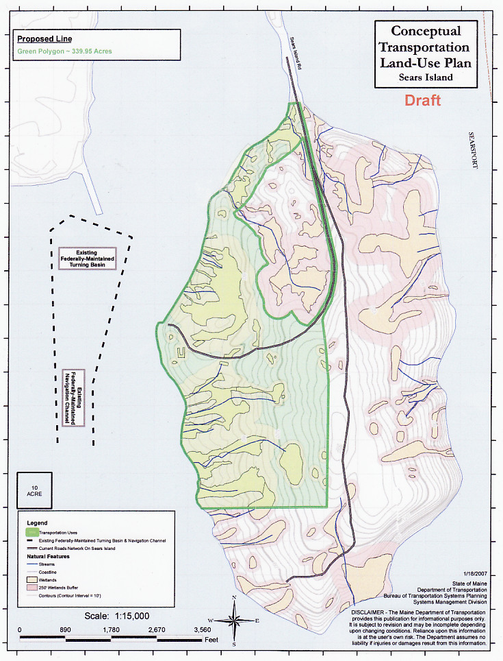
Shocking but true, the Maine chapter of the Sierra Club under the leadership of Joan Saxe has endorsed the building of an industrial port on Sears Island - a natural island long a preservation jewel in Sierra Club's crown. (The area in green would be sacrificed to industry.)

Read A summary of the present and a historic record of the past Sears Island situation

How the Sierra Club - which almost singlehandedly prevented the creation of a port there in the 1990s, and again in 2004 - allows its Maine chapter to spend meeting after meeting debating with captains of industry and government officials at meetings of the Sears Island Planning Initiative, tamely acquiescing in converting a third of the 900 acre island into an industrial sacrifice zone, with dreadful consequences for downbay fisheries--has perplexed many.

Sierra Club re-founder David Brower must be spinning in his grave!

Maine Sierra Club member Ken Cline, whose legal wizardry saved the island from woodchip port-dom in the 90s, now hunkers down on Mount Desert Island, tending his student flock at COA. His powerful defiance of the collective furies of John McKernan, Angus King, Olympia Snowe and the global transportation industry in steadfast defence of Sears Island and Penobscot Bay now oddly damped to conspicuous silence.

Vivian Newman - toughest and smartest of them all, Vice-Chair of the Sierra Club's National Marine Wildlife and Habitat Committee, frequent visitor to Sears Island, sworn to defend that which the Maine chapter's leader Joan Saxe has signed off a death warrant upon; seriously vexed by the direction things are going - Maybe she will rise to the occasion

One of the raisons d'etre for the Club's NMFWC is to "Build national and regional networks to support the work of chapters and groups on other coastal/marine issues as needed, including coastal development, shoreline erosion, ports and navigational dredging; provide information, technical assistance, and referrals."

That's what Sierra Club has always done, to the great benefit of Natre.

On July 18, 1994, the Sierra Club (and CLF) sued MDOT for violating the Clean Water Act in building the causeway, clearing land and filling wetlands on the island. A Consent Decree was signed three years later, on April 9, 1997. When the dust had settled, MDOT had been ordered to:

"restore 3.2 acres of wetlands at the cargo terminal site on Sears Island, restore and enhance a 0.75 acre wetland on south-central Sears Island, provide streambank stabilization and wetlands enhancement at Dyer Creek in North Newcastle, Maine, and expend at least $100,000 on the acquisition and conservation of Atlantic Salmon habitat on the Ducktrap River." Note: the
final consent agreement item, protecting Ducktrap River salmon habitat was recently met.

Sierra Club's national magazine touted the protection of Sears Island as "A wetland win" The club's then-president J. Robert Cox wrote:
"Combatting the Maine Department of Transportation's plans to build a cargo port at Sears Island made the last 13 years busy ones for Maine Sierra Club activists. Though the 940-acre island in Penobscot Bay provided habitat for 70 percent of the state's wetland species as well as an important flyway for neotropical birds, the agency rejected an alternative site at industrialized Mack Point. The agency flouted environmental law by neglecting to prepare an environmental impact statement and then, when forced by a Sierra Club lawsuit, delivered an EIS that ignored 200 acres of freshwater wetlands on the island. Each time the agency submitted redesigns for the port, Sierra Club lawsuits showed them to be inadequate. Club activists rejoiced when the Army Corps of Engineers finally rejected the project this February."

Is there rejoicing now among club activists?
No? Why not?

The Maine Chapter's first statement this latest go-round on Sears Island, titled
“Preservation and Port: a Recipe for Prosperity is on their website

The statement starts off well, noting

"The Sears Island Planning Initiative is uniquely charged by the Baldacci Administration with developing recommendations for the future use of the 940-acre island in Penobscot Bay. If implemented, the recommendations could end thirty years of public controversy."

It continues by calling for "permanently protecting Sears Island as an educational and recreational asset", while encouraging "full utilization of Mack Point, using best available management practices, to address the financial needs of Searsport and its transportation connections with Central and Northern Maine. "

Again it states "that the entirety of Sears Island be conserved, and that trails and management facilities be improved to fulfill its future as a regional ecotourism asset, also supporting the local economy."

The statement closes with a flourish: "The Port supported; the Island protected -- A Win/Win scenario."

Current economic and shipping information indicates that Mack Point has the potential to satisfy all marine transportation needs of Maine’s central region for the foreseeable future.

In bland sprawl-speak the Maine Chapter describes its position on Sears Island thusly:

"In a win/win scenario for jobs and preservation, participants in the Sears Island Planning Initiative announced their proposal Preservation and Port: a Recipe for Prosperity." (rtf file)


What?... Hello.....? Sierra Club?


Apr 8, 2008

Sears Island wetland kill mitigated on Ducktrap River shoreline

According to the April 8 edition of Maine State Planning Office's Weekly Highlights (pdf) the state planning office's Land for Maine's Future division has just spent the funds from the Sears Island Consent Decree, buying the Emery property: (photo) 200 feet of Ducktrap River shoreline, totalling two acres, to protect resident Atlantic Salmon spawning and juvenile habitat of that stretch of the river. Protecting the river's salmon habitat has been an ongoing process.

Here's the entry from the April 8th edition:

"SEARS ISLAND MITIGATION FUND. The Emery Parcel, Lincolnville, Waldo County. The
Land for Maine’s Future Program is responsible for administering other funds. Working
in partnership with the Coastal Mountains Land Trust, who pre-acquired this parcel,
LMF administered Sears Island Consent Decree funds to enable the Maine Department
of Inland Fisheries & Wildlife to acquire this 2.11 acre parcel. It was acquired to protect
Atlantic salmon habitat along 200’ of the Ducktrap River as well as to provide road
access to adjacent conserved lands. CONTACT: Steve Brooke at 287-6736 or Steve
Brooke or Tim Glidden at 287-1487 or Tim Glidden."

Abby Burgess retrieves lost bay lobster traps

From the Lobster Fact Blog

The U.S. Coast Guard is called upon this time of year by bay fishermen to do what they can’t — haul massive tangles of lobster traps and gear from the depths of Penobscot Bay.

Early Monday morning, as the sun began to rise over western Penobscot Bay, the Coast Guard cutter Abbie Burgess slipped out of its Rockland berth and headed for Two Bush Ledge, about seven miles south of Owls Head.

Working in conjunction with Maine Marine Patrol officers Brian Tolman, Matt Talbot, and Wes Dean, and Owls Head lobster men Scott Herrick and Jeff Woodman, the Abbie Burgess crew set out to help recover what would likely be dozens of lobster traps. (Full story)

Apr 7, 2008

Maine Port Safety Forum April 10th: LNG, whales, ice,, more.

Port Safety Forum Thursday

The quarterly Port Safety Forum meeting comes up this Thursday April 10 at 10am at the Portland Ocean Terminal. Below is the agenda and some bits from the previous meetings' minutes.

* Right Whale Sighting Update – Kristen Koyama, NMFS

* Development , feedback of NWS Marine forecast- John Cannon, NWS

*Historical Tide Levels-Steve Dickson, Maine Geological Survey

* Demolition of Waldo/Hancock Bridge-Maine DOT

* TWIC Update- (commercial sailor ID's) Al Moore USCG

* LNG Update-Al Moore, USCG

* Ice Season (Reporting, breaking requests, etc.) CWO Chase, USCG

A
t their last meeting, the Forum discussed a "Penobscot Bay maritime issues forum"
This was proposed by John Henshaw head of the Maine Port Authority under the Navigation committee. ..."Dredging and other topics would be discussed among various groups with a variety of interests: Pilots, MMA, environmental groups etc. would be perhaps involved.
"

There should be a followup on the Penobscot Bay maritime issues forum at this meeting.


More info:
Kevin Rousseau, MDOT Office of Freight Transportation
(207) 624-3565 kevin.rousseau@maine.gov

Apr 3, 2008

Sears Island - who gets to carve it up?

Like the West divvying up the Ottoman Empire, the players aboard the Sears Island Joint Use Planning Commission are poised to slice up Sears Island .

Today's Republican Journal's article today
"How will Sears Island be managed?" by Tanya Mitchell, describes how on March 28th, the
Sears Island Joint Use Planning Committee
"wrestled" over how the 600-acre conservation area will be managed once the planning ends and any activity there begins.

The ever-more-tightly-closed-circle of 'deciders' making up the Joint Use Committee have consensed on giving Maine DOT -big winner this go round of attempts to slag the island- two presents: a free hand in port configuration, and an iron hand over the conserved part of the island.

Expect commissioner Cole's post DOT future to be most richly rewarded, should he deliver Sears island to the global industrial transportation network.

How the mighty have fallen! Observe the state to which even once visionary Earth First! activist extraordinaire Jim Freeman has come. This formerly indomitable defender of natural Sears island, and to this day an implacable opponent to the E/W highway, the Transamerica NAFTA highway and all those global corporate byways and highways strangling our planet, has consensed and signed off on a port configuration for Sears Island that will double the amount of cargo containers entering and departing Maine by rail and truck! A port that will stimulate the East West Highway, and will tie neatly into the NAFTA highway from Mexico to Canada. But that is just what Mr. Freeman has done. According to Mitchell's article:

"JUPC member Jim Freeman said if a group like Friends of Sears Island was interested in occupying the island, it would need to draft a use plan and meet with the council to discuss its intentions. would go through a bid process that would spell out details on intended uses for the island and associated construction costs. Once the final proposals and bid information is compiled, Freeman said, DOT will make the final decision."

While Jim is unarguably a contractor par excellence who has played a role in the revitalzing of downtown Bangor, turning use of Sears Island into a biddable competition is not likely what the Great Spirit had in Mind for Wassumkeag's shining sands.

Perhaps a Sears Island live call-in show should be organized on WERU Community Radio which has featured Sears Island in earlier years There, Freeman and others of the Sears Island Joint Use Planning Committee can explain their new plan for Sears Island to the local Maine environmental community.


Mar 27, 2008

Sears Island: Does JUPC's reach exceed its grasp?

Critics of the port+park plan unfolding under the auspices of the Sears Island Joint Planning Committee say that the level of expertise on conservation and environmental issues that are endemic to the plan fall far short of what is needed. See map

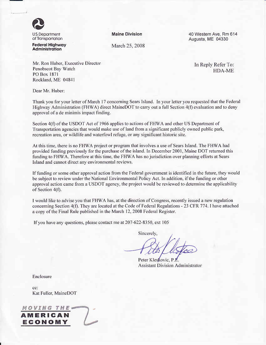
But the Federal Highway Administration has washed its hands of Sears Island, recently declaring it has no requirement to review what is presently a state action.

Thus it is up to the state of Maine to provide the scrutiny of the plan's likely impacts to Penobscot Bay's fishery generally, to the island's eelgrass meadows, and upland wildlife and vegetation.

Maine DOT's process for Sears Island is remarkably similar to Plum Creek's plan for the Moosehead Lake region: ambitious development plan, but woefully short on detail.

Very little has been revealed - proposal for three lines of track , a new heavy duty roadway, MDOT request for realignment to allow 7,000 foot trains on-island. MDOT clearly has more than a vague fuzzy idea of what is up its sleeve for Wassumkeag, as the Native Americans call this gorgeous keystone island.

Plum Creek's paucity of detail when they unveiled their plan set off a public outcry that lead to the lengthy comprehensive public hearings, where every detail of the company's plan and its impact to the natural environment was made clear.

It is time for this to happen to the Sears Island Joint Use Planning Committee's plan for the future development of sears island. Let's bring MDOT's plans for the island into sharp focus, and let the public and the myriad state and federal agencies with decades of expertise on the island come forth and explain to the Maine Board of Environmental Protection what is at stake.

Under Maine statute called "Site Law", Section MRSA 38 sec 485-1-C. Approval of future development sites, the Department of Environmental Protection can require a would-be large scale developer to apply for a "Planning Permit" for any:

"development within a specified area and within specified parameters such as maximum area, groundwater usage and traffic generation, although the specific nature and extent of the development or timing of construction may not be known at the time the permit is issued. "

Sound familiar? Let's find out if the Maine Board of Environmental Protection will give this a hard look. Watch this space...


T

Mar 25, 2008

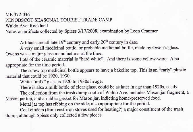
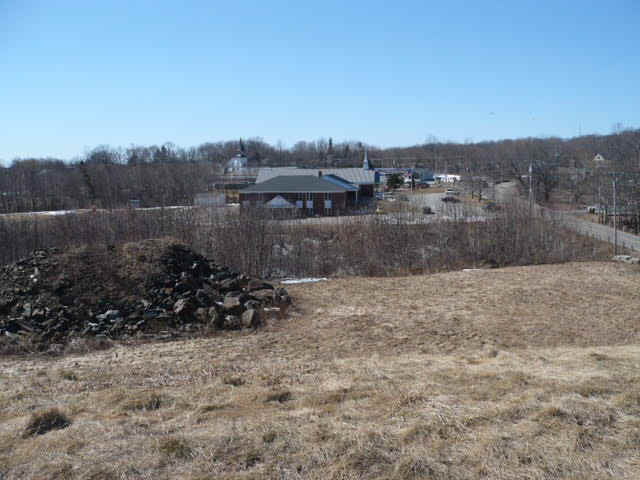
Historic Wabanaki camp in Rockland ravine to be 'time capsuled'.

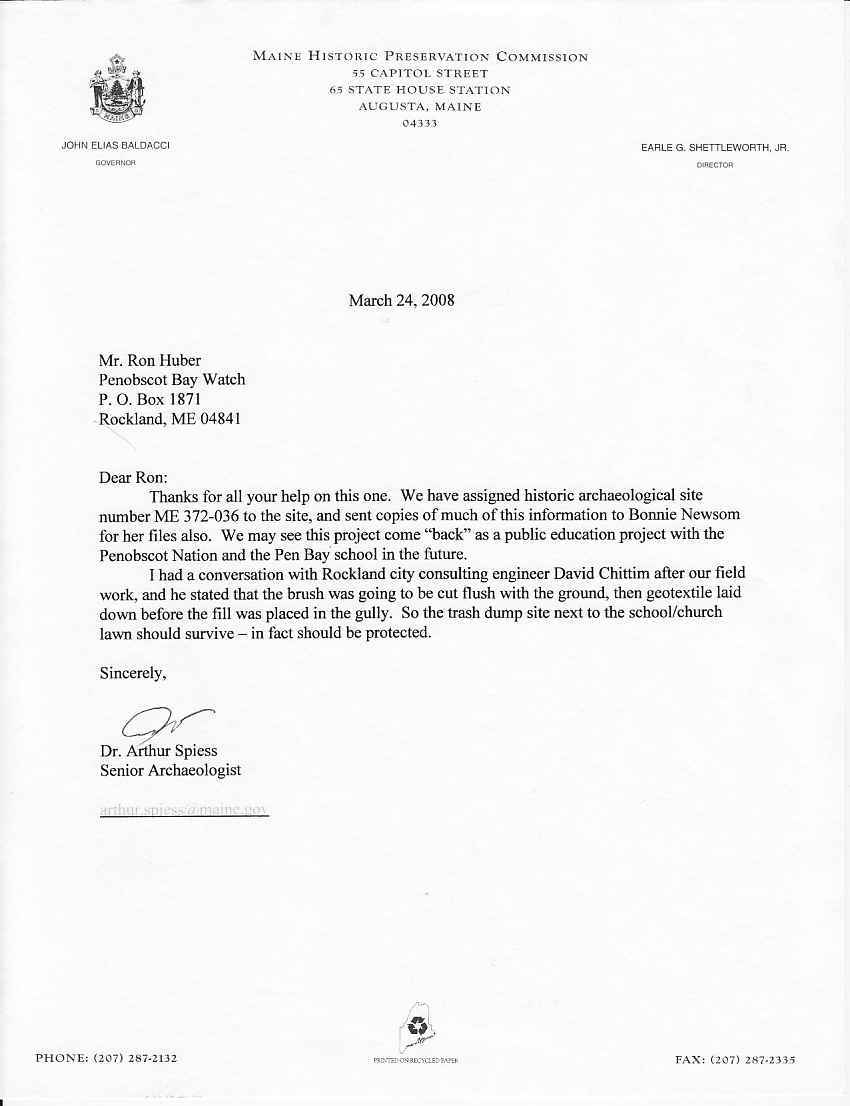
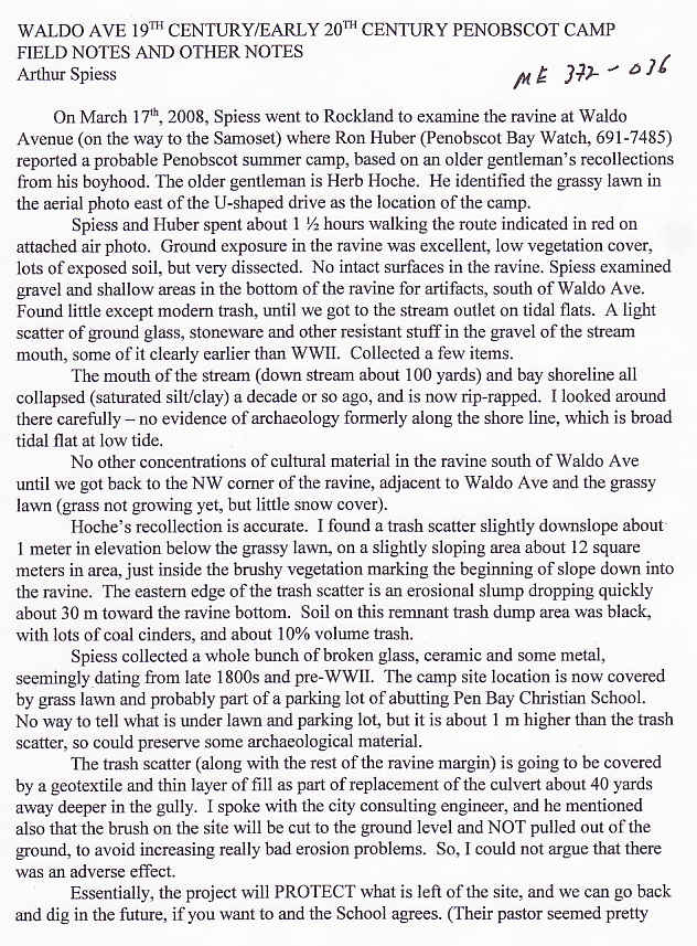
Maine State Archaeologist Arthur Spiess has written us with a report on his recent examination of a ravine on the northwest edge of Rockland Harbor. He'd gone there an inquiry from Penobscot Bay Watch concerning a recollection from a retired fisherman that Indians had made a summer camp there in the 1940s. The camp's location on the then-Samoset Road allowed them to sell basketry and other craft goods to tourists visiting or departing the first Samoset Resort.

Archaeologist Arthur Spiess found an relatively undisturbed trash midden on the upper edge of the ravine. Its contents dated from the late 19th century to the 1940s, leading him to concur with the fisherman's account--that a summertime Indian encampment occupied the ravine site in the late 19th and early 20th centuries.

If confirmed, the location, dubbed ME 372-036 would be the first coastal Indian campsite of that era to be found and examined in midcoast Maine.
Audio mp3 of the field visit. More Details: Click here Examination will have to wait, as ME 372-036 will be lightly buried upon the imminent filling of the ravine. Covered by geotextile cloth, then soil and sod, it will be available for future archeological digs in the coming years.

Dr. Spiess' further inquiries have found that Passmaquoddy Indians also camped at the ravine site.


Mar 24, 2008

Sears Island: NMFS reenters island fight.

The National Marine Fisheries Service is concerned with the direction of the Sears Island Joint Use Planning Committee is taking. The agency's opposition to the 1995 port proposal helped stop it.

Not bound by the strictures of the agreement that JUPC-ites labor under, NMFS is calling for a comprehensive conservation review of the proposed agreement, pursuant to the Magnuson-Stevens Act and Fish and Wildlife Coordination Act,

Under 49 USC 303, the federal transportation law commonly called "Section 4(f)
the Maine DOT and Federal Highway Administration must run their proposal to turn public land into an industrial port before the natural resrouces agencies with stewardship over the resources at risk. This includes NMFS for the eelgrass and clamflats, US Fish and Wildlife for freshwater fish and wildlife, and US EPA for the wetlands that would harmed.

Turns out that MDOT and FHWA hadn't contacted any of the three, so I did it for them. So far NMFS has risen to the challenge. Will the other agencies?

US FHWA has promised a response this week, on the Penobscot Bay Watch request, and presumably on those from NMFS and Maine Green Independent Party, other NGOs and other federal agencies, should they follow NMFS' lead. Stay tuned.

Mar 18, 2008

PEER: No new port on Sears Island!

EAST COAST’S LARGEST UNDEVELOPED ISLAND SLATED FOR CARGO PORT — Development Scheme for Maine’s Sears Island Resurfaces Again after 12 Years

Washington, DC — The Maine Department of Transportation wants to turn Sears Island in Penobscot Bay into a cargo container port, according to an agency scenario released today by Public Employees for Environmental Responsibility (PEER). Under the plan, more than a third of the largest uninhabited island on the Eastern Seaboard would be paved over. The rest of the island would be used as a “mitigation bank” to facilitate wetlands destruction in other parts of the state. See Maine DOT's 2008 sales prospectus for Sears Island! (20 page pdf)

...snip...

“Carving up Sears Island was a bad idea a decade ago and is even a worse idea now,” stated New England PEER Director Kyla Bennett, a biologist and lawyer who formerly worked for the EPA, noting that the DOT Prospectus brags that “protection of parts of Sears Island would add a significant jewel” to Maine’s conservation efforts. “If protecting ‘parts’ of Sears Island would add a jewel, saving all of Sears Island would be like appending the Hope Diamond.”

A mitigation credit bank allows developers to buy the right to fill in naturally functioning wetlands by purchasing the promise of the creation or restoration of wetlands elsewhere. In the case of Sears Island, DOT proposes that some lands be saved only in exchange for the destruction of wetlands elsewhere in the state. In addition, there are big questions about whether Sears Island could function as a mitigation bank.

“Offering Sears Island up for a wetland mitigation bank does not even pass the straight face test when the only restoration opportunities on the island consist of two sites, totaling three-eighths of an acre,” Bennett added. “The Governor of Maine should put an end to these ridiculous development scenarios and save Sears Island once and for all.”

Read Full article

Mar 16, 2008

Sears Island: Raising the bar for MDOT

Will her wetlands and eelgrass, her ferns and forests, her historic and prehistoric artifacts, her beaches and sandbars be protected from industrial development?

In the 1990s, the answer was YES

But if Maine Department of Transportation has its way this time: NO. (Click pic for larger image)

MDOT proposes divvying up Sears Island, taking a third for a future industrial port, leaving the other two thirds natural, (though allowing ENGOs to build an educational center in that natural area.)

But before the deal becomes official, Maine DOT has to satisfy the federal government that it has obeyed a certain federal law: 49 USC § 303 Policy on lands, wildlife and waterfowl refuges, and historic sites Because under the regulations of this 4(f) law, the Federal Highway Administration can not approve plans for future development of a port on a public land island until Maine DOT:

(1) identifies the wildlife, historic and recreational resources that would be affected directly or indirectly;
(2) Shows there is no feasible and prudent alternative to the use of land from the property; and
(3) Demonstrates how the proposed action includes all possible planning to minimize harm to the property and its resources resulting from such use.

So before Maine Dept of Transportation can move ahead with any plans, it needs to submit a report to the federal government showing:

(1) what wildlife, historic and recreational assets exist in, on and adjacent to their third of the island. Lots of info pertaining to WILDLIFE is available from the 1990s Environmental Impact Study (EIS) made for proposed port on the island in the 1990s. Not so for HISTORIC and RECREATIONAL assets. Maine DOT will have to hire a consultant to gather information on those two assets.

(2) what wildlife, historic and recreational assets the port would destroy or damage that exist in, on and adjacent to their third of the island. Again the 1990s EIS and other studies and reviews carried out by federal and state agencies in the 1990s will describe much of these assets and the likely adverse impacts of port development on Sears Island.

(3) What alternatives there are that would allow similar kind of development, but off of the island. Mack Point? Orrington, Bangor? Portland? Halifax?


So lets look at some details of what ought to be in Maine DOT's DRAFT version of their Section 4(f) report to the FHWA.

1. Description of Project
Describe the proposed project, including the purpose and need for the project.

2. A brief introduction that identifies:
a. The basic requirements of Section 4(f).
b. The Section 4(f) resource(s) affected.
c. The alternatives under consideration that would affect the Section 4(f) resource(s).

3. Description of each Section 4(f) resource:

a. A detailed map or drawing of sufficient scale to identify the relationship of the alternatives to the Section 4(f) property.
b. Size (acres or square feet) and location (maps, sketches, etc.) of the affected Section 4(f) property.
c.Type of property (recreation, historic, wildlife.) and ownership (public, private etc.).
d. Function of or available activities on the property (swimming, golfing, baseball, wildlife habitats.).
e. Description and location of all existing and planned facilities (tennis courts, baseball diamonds, etc.).
f. Access (pedestrian, vehicular) and usage (approximate number of users/visitors, etc.).
g. Relationship to other similarly used lands in the vicinity.
h. Relationship to ecologically important wildlife areas adjacent to the prooerty.
i. Applicable clauses affecting the ownership, such as lease, easement, covenants, restrictions, or conditions, including forfeiture.
j Unusual characteristics (flooding problems, terrain conditions, high value viewshed, rare or significant wildlife habitat or other features) that reduce or enhance the value of all or part of the property.

4. Environmental impacts during construction for each alternative on each Section 4(f) property (quantify where possible):

a. Acquisition of land (acres or square feet) and facilities (include map).
b. Access.
c. Aesthetics.
d. Air Quality.
e. Noise.
f. Water.
g. Wildlife/Fisheries
h. Land use in the vicinity.

5. Environmental impacts during operation for each alternative on each Section 4(f) property:

a. Acquisition of land (acres or square feet), if different from construction impact, and facilities (include map).
b. Access.
c. Aesthetics.
d. Air Quality.
e. Noise.
f. Water.
g. Wildlife/Fisheries
h. Land use in the vicinity. Include impacts of growth induced by project.

6. Avoidance alternatives and their impacts.

Identify and evaluate location and design alternatives that would avoid harm to the Section 4(f) property and its surrounds.

Generally, this would include alternatives to either side of the property. Where an alternative would use land from more than one Section 4(f) property, the analysis needs to evaluate alternatives which avoid each and all properties (23 CFR 771.135(i)).

The design alternatives should be in the immediate area of the property and consider minor alignment shifts, a reduced facility, retaining structures, etc., individually or in combination, as appropriate.

Detailed discussions of alternatives in an EIS or EA need not be repeated in the Section 4(f) portion of the document, but should be referenced and summarized.

However, when alternatives (avoiding Section 4(f) resources) have been eliminated from detailed study, the discussion should also explain whether these alternative are feasible and prudent and, if not, the reasons why. (T 6640.8A, p. 45.)

7. Mitigation measures, commitments, and monitoring procedures to minimize harm. Discuss all possible measures which are available to minimize the impacts of the proposed action on the Section 4(f) property(ies). Detailed discussions of mitigation measures in the EIS or EA may be referenced and appropriately summarized, rather than repeated. (T 6640.8A, p. 46.)

8. Coordination with other agencies The coordination should include a discussion of avoidance alternatives, impacts, and measures to minimize harm:

a. State Historic Preservation Officer/State Wildlife/Marine/Environmental Commissioners.
b. Local officials with jurisdiction.
c. Historic societies, conservation and environmental groups, museums, academic institutions.
d. Historic consultant.
e. Archaeological consultant.
f. Wildlife Consultant.
g. Fisheries.
h. Wetlands Consultant
i. Recreation Consultant.
j. Advisory Council on Historic Preservation (ACHP).
k. Indian Tribes

IT IS DOUBTFUL THAT MAINE DOT HAS INCLUDED ALL THESE DETAILS IN THEIR SECTOIN 4(F) APPLICATION TO THE FHWA.

Let's make make sure they do it, and do it right!