Curiouser and curiouser....
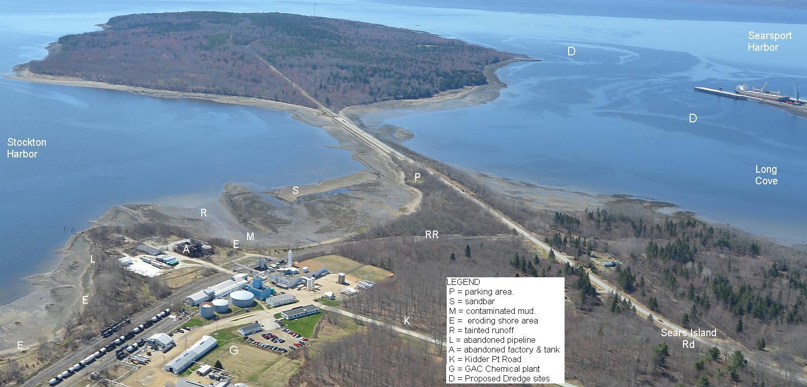
Our Friday visit to Maine DEP's Bangor office to look at the pollution history of GAC Chemical and polluters past on Kidder Point had its highs and its lows.

The bad news: The agency has for the third time cancelled its site visit to examine GAC's shore in light of our complaints. A sudden scheduling conflict; the field investigative team is needed elsewhere. Improbable, given the number of times the agency visit to this polluted site has already been delayed. Did our unexpected introduction of the fertilizer waste problem into the Kidder Point cleanup discussion freak DEP out?
Was this a political postponement of the investigation? I.e. did a call from the head of "Maine's Chemical Company" to Governor Lepage lead to ruthlessly pro-industry Patty Aho Commissioner being tasked to throttle back her employees' rush to examine that polluted shore? One wonders. Meetings with the top GAC guy David Colter started well, too but petered out over the course of the year into canceled meetings and postponed cleanup plans.
 The good news: We got access to about a thousand pages of well organized documents, charts, maps etc from two sub-bureaus, solid waste and remediation (polluted sites cleanup). The two officials that greeted us were professional and helpful. Split among four of us, and a patient DEP receptionist/copy machine operator, we extracted about 180 pages of maps, charts, core sample data, pollution evaluations, enforcement letters/ replies and more. These will appear on the Friends of Penobscot Bay website as they get digitized.

The missing news: We saw DEP's attention was on the top layers of alum production waste laid down after fertilizer production shut down in 1970. But where did the 11 million tons of chemical waste from fifty years of fertilizer production on Kidder Point and Mack Point go?
Made by sulfuric acid drenching of phosphate ore, every ton of superphosphate leaves five tons of useless, unhealthily radioactive and highly acidic waste "phosphogypsum" behind. Phosphogypsum (PG) is a problem powdery waste. Too much radium, uranium and radon for use in inhabited areas, according to US EPA. But every day more thousands of tons are produced around the world. So much that it is piled in enormous stacked pyramids around the world, some of them visible from outer space thanks to our fertilizer-using planetary civilization.
Searsport's fertilizer's main market was the state's potato farms. Phosphate ore and sulfur arrived at Mack Point by ship; fertilizer went from Searsport to the tater-growing County by rail. Potatoes came back down the rail to Searsport for export.
Kidder Point & Mack Point both hosted a series of fertilizer companies:
1907 American Agricultural Chemical Company built plant and pier. Mack Pt
1907-1914 B&A RR runs electric power plant on Kidder Point for AACC, etc.
1909 Hubbard (later Armour) Fertilizer sets up Mack Pt
1919 Summers Fertilizer Kidder Pt
1944 Northern Chemical Kidder Point
1966 W.R. Grace Kidder Pt
1970 Delta Chemical Kidder Pt
1994 to present: General Alum and Chemical(GAC) Kidder Point
Superphosphate was made there. Lots of it.
In 1962 alone, Searsport would have generated 225,000 tons of waste while making 45,000 tons of superphosphate. Where is it? Over fifty years, around 11 million tons of phosphogypsum would have been discarded in Searsport. Where is that?
It is logical that the abovementioned companies would deposit this toxic material nearby as possible. It is most likely lining Kidder Point, Mack Point and even Sears Island and was probably dumped into abandoned quarries like those in Northport. The amount of postponing by both the company and by MDEP suggests something is wrong on the shores of Stockton Harbor.
GAC Chemical and Maine DEP would do better to speedily investigate the site and get the necessary remediation done and over with. Stockton Harbor, with its entrance only yards from the mouth of Penobscot River, is a very important part of Penobscot Bay's estuary system. A century of waste deposition and spillage into it from Kidder Point is a legacy that must be confronted and dealt with.
Time to get the site investigation rescheduled AGAIN.
Our Friday visit to Maine DEP's Bangor office to look at the pollution history of GAC Chemical and polluters past on Kidder Point had its highs and its lows.

The bad news: The agency has for the third time cancelled its site visit to examine GAC's shore in light of our complaints. A sudden scheduling conflict; the field investigative team is needed elsewhere. Improbable, given the number of times the agency visit to this polluted site has already been delayed. Did our unexpected introduction of the fertilizer waste problem into the Kidder Point cleanup discussion freak DEP out?
Was this a political postponement of the investigation? I.e. did a call from the head of "Maine's Chemical Company" to Governor Lepage lead to ruthlessly pro-industry Patty Aho Commissioner being tasked to throttle back her employees' rush to examine that polluted shore? One wonders. Meetings with the top GAC guy David Colter started well, too but petered out over the course of the year into canceled meetings and postponed cleanup plans.


The missing news: We saw DEP's attention was on the top layers of alum production waste laid down after fertilizer production shut down in 1970. But where did the 11 million tons of chemical waste from fifty years of fertilizer production on Kidder Point and Mack Point go?
Searsport's fertilizer's main market was the state's potato farms. Phosphate ore and sulfur arrived at Mack Point by ship; fertilizer went from Searsport to the tater-growing County by rail. Potatoes came back down the rail to Searsport for export.
Kidder Point & Mack Point both hosted a series of fertilizer companies:
1907-1914 B&A RR runs electric power plant on Kidder Point for AACC, etc.
1909 Hubbard (later Armour) Fertilizer sets up Mack Pt
1919 Summers Fertilizer Kidder Pt
1944 Northern Chemical Kidder Point
1966 W.R. Grace Kidder Pt
1970 Delta Chemical Kidder Pt
1994 to present: General Alum and Chemical(GAC) Kidder Point
Superphosphate was made there. Lots of it.
In 1962 alone, Searsport would have generated 225,000 tons of waste while making 45,000 tons of superphosphate. Where is it? Over fifty years, around 11 million tons of phosphogypsum would have been discarded in Searsport. Where is that?
GAC Chemical and Maine DEP would do better to speedily investigate the site and get the necessary remediation done and over with. Stockton Harbor, with its entrance only yards from the mouth of Penobscot River, is a very important part of Penobscot Bay's estuary system. A century of waste deposition and spillage into it from Kidder Point is a legacy that must be confronted and dealt with.
Time to get the site investigation rescheduled AGAIN.