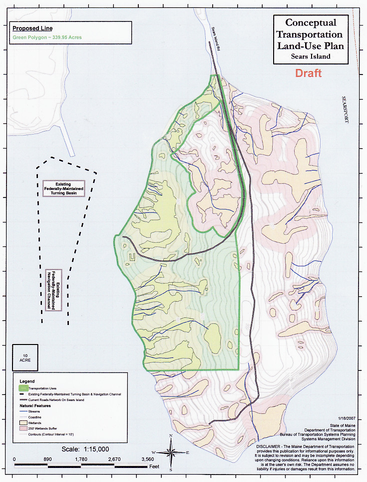
Critics of the port+park plan unfolding under the auspices of the Sears Island Joint Planning Committee say that the level of expertise on conservation and environmental issues that are endemic to the plan fall far short of what is needed. See map
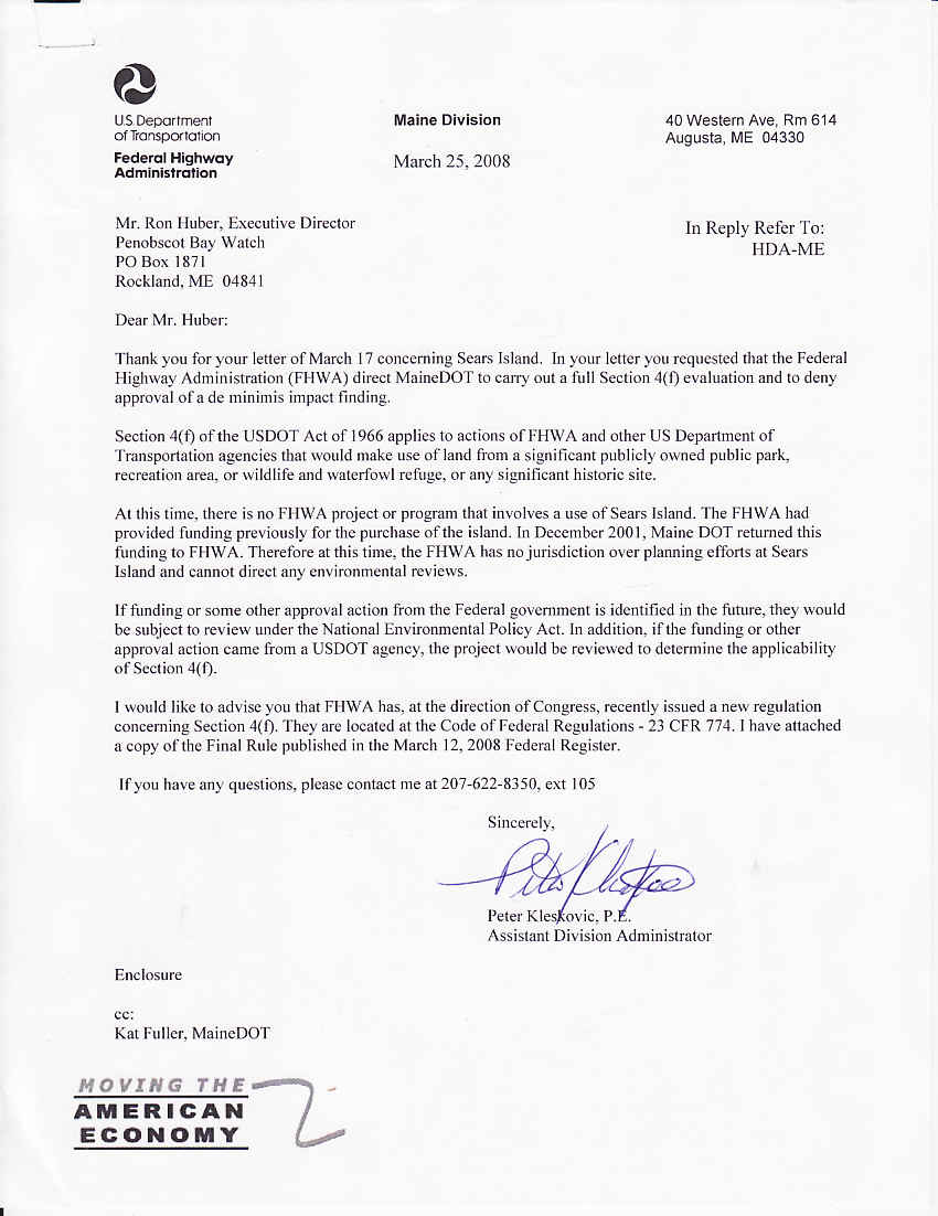
But the Federal Highway Administration has washed its hands of Sears Island, recently declaring it has no requirement to review what is presently a state action.
Thus it is up to the state of Maine to provide the scrutiny of the plan's likely impacts to Penobscot Bay's fishery generally, to the island's eelgrass meadows, and upland wildlife and vegetation.
Maine DOT's process for Sears Island is remarkably similar to Plum Creek's plan for the Moosehead Lake region: ambitious development plan, but woefully short on detail.
Very little has been revealed - proposal for three lines of track , a new heavy duty roadway, MDOT request for realignment to allow 7,000 foot trains on-island. MDOT clearly has more than a vague fuzzy idea of what is up its sleeve for Wassumkeag, as the Native Americans call this gorgeous keystone island.
Plum Creek's paucity of detail when they unveiled their plan set off a public outcry that lead to the lengthy comprehensive public hearings, where every detail of the company's plan and its impact to the natural environment was made clear.
It is time for this to happen to the Sears Island Joint Use Planning Committee's plan for the future development of sears island. Let's bring MDOT's plans for the island into sharp focus, and let the public and the myriad state and federal agencies with decades of expertise on the island come forth and explain to the Maine Board of Environmental Protection what is at stake.
Under Maine statute called "Site Law", Section MRSA 38 sec 485-1-C. Approval of future development sites, the Department of Environmental Protection can require a would-be large scale developer to apply for a "Planning Permit" for any:
"development within a specified area and within specified parameters such as maximum area, groundwater usage and traffic generation, although the specific nature and extent of the development or timing of construction may not be known at the time the permit is issued. "
Sound familiar? Let's find out if the Maine Board of Environmental Protection will give this a hard look. Watch this space...
T


Mar 25, 2008
Historic Wabanaki camp in Rockland ravine to be 'time capsuled'.
 Maine State Archaeologist Arthur Spiess has written us with a report on his recent examination of a ravine on the northwest edge of Rockland Harbor. He'd gone there an inquiry from Penobscot Bay Watch concerning a recollection from a retired fisherman that Indians had made a summer camp there in the 1940s. The camp's location on the then-Samoset Road allowed them to sell basketry and other craft goods to tourists visiting or departing the first Samoset Resort.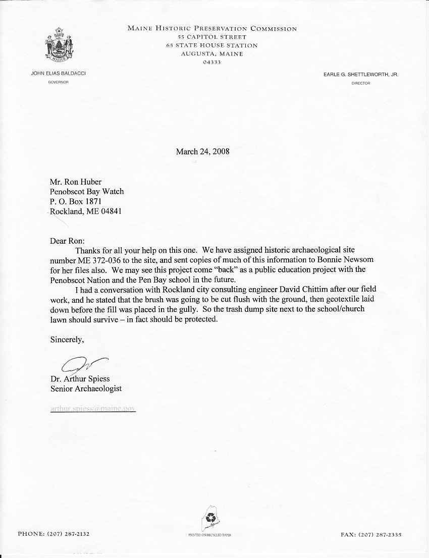
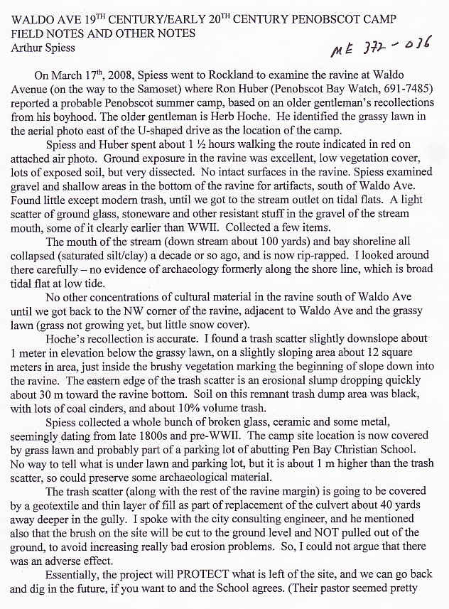

Archaeologist Arthur Spiess found an relatively undisturbed trash midden on the upper edge of the ravine. Its contents dated from the late 19th century to the 1940s, leading him to concur with the fisherman's account--that a summertime Indian encampment occupied the ravine site in the late 19th and early 20th centuries.
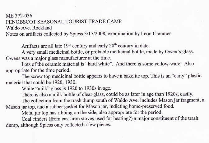
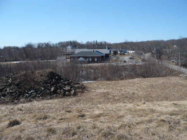
If confirmed, the location, dubbed ME 372-036 would be the first coastal Indian campsite of that era to be found and examined in midcoast Maine. Audio mp3 of the field visit. More Details: Click here Examination will have to wait, as ME 372-036 will be lightly buried upon the imminent filling of the ravine. Covered by geotextile cloth, then soil and sod, it will be available for future archeological digs in the coming years.
Dr. Spiess' further inquiries have found that Passmaquoddy Indians also camped at the ravine site.
Mar 24, 2008
Sears Island: NMFS reenters island fight.
 The National Marine Fisheries Service is concerned with the direction of the Sears Island Joint Use Planning Committee is taking. The agency's opposition to the 1995 port proposal helped stop it.
Not bound by the strictures of the agreement that JUPC-ites labor under, NMFS is calling for a comprehensive conservation review of the proposed agreement, pursuant to the Magnuson-Stevens Act and Fish and Wildlife Coordination Act,
Under 49 USC 303, the federal transportation law commonly called "Section 4(f)
the Maine DOT and Federal Highway Administration must run their proposal to turn public land into an industrial port before the natural resrouces agencies with stewardship over the resources at risk. This includes NMFS for the eelgrass and clamflats, US Fish and Wildlife for freshwater fish and wildlife, and US EPA for the wetlands that would harmed.
Turns out that MDOT and FHWA hadn't contacted any of the three, so I did it for them. So far NMFS has risen to the challenge. Will the other agencies?
US FHWA has promised a response this week, on the Penobscot Bay Watch request, and presumably on those from NMFS and Maine Green Independent Party, other NGOs and other federal agencies, should they follow NMFS' lead. Stay tuned.
Mar 18, 2008
PEER: No new port on Sears Island!
 EAST COAST’S LARGEST UNDEVELOPED ISLAND SLATED FOR CARGO PORT — Development Scheme for Maine’s Sears Island Resurfaces Again after 12 Years
Washington, DC — The Maine Department of Transportation wants to turn Sears Island in Penobscot Bay into a cargo container port, according to an agency scenario released today by Public Employees for Environmental Responsibility (PEER). Under the plan, more than a third of the largest uninhabited island on the Eastern Seaboard would be paved over. The rest of the island would be used as a “mitigation bank” to facilitate wetlands destruction in other parts of the state. See Maine DOT's 2008 sales prospectus for Sears Island! (20 page pdf)
“Carving up Sears Island was a bad idea a decade ago and is even a worse idea now,” stated New England PEER Director Kyla Bennett, a biologist and lawyer who formerly worked for the EPA, noting that the DOT Prospectus brags that “protection of parts of Sears Island would add a significant jewel” to Maine’s conservation efforts. “If protecting ‘parts’ of Sears Island would add a jewel, saving all of Sears Island would be like appending the Hope Diamond.”
A mitigation credit bank allows developers to buy the right to fill in naturally functioning wetlands by purchasing the promise of the creation or restoration of wetlands elsewhere. In the case of Sears Island, DOT proposes that some lands be saved only in exchange for the destruction of wetlands elsewhere in the state. In addition, there are big questions about whether Sears Island could function as a mitigation bank.
“Offering Sears Island up for a wetland mitigation bank does not even pass the straight face test when the only restoration opportunities on the island consist of two sites, totaling three-eighths of an acre,” Bennett added. “The Governor of Maine should put an end to these ridiculous development scenarios and save Sears Island once and for all.”
Read Full articleMar 16, 2008
Sears Island: Raising the bar for MDOT
 Will her wetlands and eelgrass, her ferns and forests, her historic and prehistoric artifacts, her beaches and sandbars be protected from industrial development?
In the 1990s, the answer was YES
But if Maine Department of Transportation has its way this time: NO. (Click pic for larger image)
MDOT proposes divvying up Sears Island, taking a third for a future industrial port, leaving the other two thirds natural, (though allowing ENGOs to build an educational center in that natural area.)
But before the deal becomes official, Maine DOT has to satisfy the federal government that it has obeyed a certain federal law: 49 USC § 303 Policy on lands, wildlife and waterfowl refuges, and historic sites Because under the regulations of this 4(f) law, the Federal Highway Administration can not approve plans for future development of a port on a public land island until Maine DOT:
(1) identifies the wildlife, historic and recreational resources that would be affected directly or indirectly;
(2) Shows there is no feasible and prudent alternative to the use of land from the property; and
(3) Demonstrates how the proposed action includes all possible planning to minimize harm to the property and its resources resulting from such use.
So before Maine Dept of Transportation can move ahead with any plans, it needs to submit a report to the federal government showing:
(1) what wildlife, historic and recreational assets exist in, on and adjacent to their third of the island. Lots of info pertaining to WILDLIFE is available from the 1990s Environmental Impact Study (EIS) made for proposed port on the island in the 1990s. Not so for HISTORIC and RECREATIONAL assets. Maine DOT will have to hire a consultant to gather information on those two assets.
(2) what wildlife, historic and recreational assets the port would destroy or damage that exist in, on and adjacent to their third of the island. Again the 1990s EIS and other studies and reviews carried out by federal and state agencies in the 1990s will describe much of these assets and the likely adverse impacts of port development on Sears Island.
(3) What alternatives there are that would allow similar kind of development, but off of the island. Mack Point? Orrington, Bangor? Portland? Halifax?
So lets look at some details of what ought to be in Maine DOT's DRAFT version of their Section 4(f) report to the FHWA.
1. Description of Project
Describe the proposed project, including the purpose and need for the project.
2. A brief introduction that identifies:
a. The basic requirements of Section 4(f).
b. The Section 4(f) resource(s) affected.
c. The alternatives under consideration that would affect the Section 4(f) resource(s).
3. Description of each Section 4(f) resource:
a. A detailed map or drawing of sufficient scale to identify the relationship of the alternatives to the Section 4(f) property.
b. Size (acres or square feet) and location (maps, sketches, etc.) of the affected Section 4(f) property.
c.Type of property (recreation, historic, wildlife.) and ownership (public, private etc.).
d. Function of or available activities on the property (swimming, golfing, baseball, wildlife habitats.).
e. Description and location of all existing and planned facilities (tennis courts, baseball diamonds, etc.).
f. Access (pedestrian, vehicular) and usage (approximate number of users/visitors, etc.).
g. Relationship to other similarly used lands in the vicinity.
h. Relationship to ecologically important wildlife areas adjacent to the prooerty.
i. Applicable clauses affecting the ownership, such as lease, easement, covenants, restrictions, or conditions, including forfeiture.
j Unusual characteristics (flooding problems, terrain conditions, high value viewshed, rare or significant wildlife habitat or other features) that reduce or enhance the value of all or part of the property.
4. Environmental impacts during construction for each alternative on each Section 4(f) property (quantify where possible):
a. Acquisition of land (acres or square feet) and facilities (include map).
b. Access.
c. Aesthetics.
d. Air Quality.
e. Noise.
f. Water.
g. Wildlife/Fisheries
h. Land use in the vicinity.
5. Environmental impacts during operation for each alternative on each Section 4(f) property:
a. Acquisition of land (acres or square feet), if different from construction impact, and facilities (include map).
b. Access.
c. Aesthetics.
d. Air Quality.
e. Noise.
f. Water.
g. Wildlife/Fisheries
h. Land use in the vicinity. Include impacts of growth induced by project.
6. Avoidance alternatives and their impacts.
Identify and evaluate location and design alternatives that would avoid harm to the Section 4(f) property and its surrounds.
Generally, this would include alternatives to either side of the property. Where an alternative would use land from more than one Section 4(f) property, the analysis needs to evaluate alternatives which avoid each and all properties (23 CFR 771.135(i)).
The design alternatives should be in the immediate area of the property and consider minor alignment shifts, a reduced facility, retaining structures, etc., individually or in combination, as appropriate.
Detailed discussions of alternatives in an EIS or EA need not be repeated in the Section 4(f) portion of the document, but should be referenced and summarized.
However, when alternatives (avoiding Section 4(f) resources) have been eliminated from detailed study, the discussion should also explain whether these alternative are feasible and prudent and, if not, the reasons why. (T 6640.8A, p. 45.)
7. Mitigation measures, commitments, and monitoring procedures to minimize harm. Discuss all possible measures which are available to minimize the impacts of the proposed action on the Section 4(f) property(ies). Detailed discussions of mitigation measures in the EIS or EA may be referenced and appropriately summarized, rather than repeated. (T 6640.8A, p. 46.)
8. Coordination with other agencies The coordination should include a discussion of avoidance alternatives, impacts, and measures to minimize harm:
a. State Historic Preservation Officer/State Wildlife/Marine/Environmental Commissioners.
b. Local officials with jurisdiction.
c. Historic societies, conservation and environmental groups, museums, academic institutions.
d. Historic consultant.
e. Archaeological consultant.
f. Wildlife Consultant.
g. Fisheries.
h. Wetlands Consultant
i. Recreation Consultant.
j. Advisory Council on Historic Preservation (ACHP).
k. Indian Tribes
IT IS DOUBTFUL THAT MAINE DOT HAS INCLUDED ALL THESE DETAILS IN THEIR SECTOIN 4(F) APPLICATION TO THE FHWA.
Let's make make sure they do it, and do it right!
Feb 6, 2008
Sears Island: state trying to avoid Section 4(f) future EIS on latest cargoport proposal?
Under the Sears Island Planning Initiative,
 Maine DOT has a fast paced stakeholder process going the Sears Island Joint Use Planning Committee (SIJUPC) a group of citizens and public and commercial interests brought together to develop a long-term plan for Sears Island. Skillfully railroa__....err...managed by the agency, its allies and the facilitator, the planning committee could swiftly finalize a proposal for the island's bifurcation into port industrial zone and conservation zone, avoiding repetition of the 1990s struggle for and against a port there.
So the last thing MDOT wants right now is to have to shell out to hire consultants to prepare an environmental impact statement that could take years to finalize, describing the likely effects of port construction. Especially since during that last go round, Angus King had to order Maine DOT to pull its application for an island port once it proved to the Army Corps of Engineers it could not compensate for the damage it would cause to the land and nearshore ecology and environment of Sears Island.
Flash forward to the present. Beginning February 8th Four meetings of the JUPC are scheduled : Feb 8th and 15th, and March 14th and 29th. All are open to the public and have time specifically set aside for members of the public to make statements.
Friday, February 8, meeting of the Sears Island Joint Use Planning Committee at the First Congregational Church, 8 Church Street, Searsport from Noon to 3pm.
 In the minutes of the last JUPC meeting, the Joint Use Planning Committee decided that MCHT's application to steward the island meets its standards for consideration. The next step, the wording of an easement agreement. Ciona Ulbrich, a staffer of the Maine Coast Heritage Trust) said MCHT would be working with the Committee to draft this document.
JUPC also pondered a federal transportation law 49 U.S.C. 303, Policy on lands, wildlife and waterfowl refuges, and historic sites. Commonly called called Section 4(f).
A review of a large transportation related project proposal under Section 4(f) either triggers or doesn't trigger the need for a thorough EIS type study of the damage a major transportation project could have on the scenic, historic and archaeologic and wildlife resources.
See full law below the membership list of the Joint Use planning Committee:
Membership of the Sears Island Joint Use Planning Committee,
(as of July 5, 2007..Some changes may have occurred)
Government
David Cole, Commissioner, Maine DOT
Rosaire Pelletier, Maine Department of Conservation
Eliza Townsend, Deputy Commissioner, Maine Department of Conservation
Sara Bradford, First Selectman, Town of Stockton Springs
James Gillway, Town Manager, Town of Searsport
Conservation
Scott Dickerson, Executive Director, Coastal Mountains Land Trust
Jim Freeman, President, Friends of Sears Island
Steve Miller, Islesboro Island Land Trust
Joan Saxe, Sierra Club
Dianne Smith, Chair, Sears Island Alternative Use Committee
Industry
Robert Grindrod, Montreal, Maine & Atlantic Railway
Sandy Blitz, EMDC; Exec. Dir. East-West Highway Assn.
Bob Ziegelaar, Telford Group
Local residents
Anne Crimaudo, Searsport
Bruce Probert, Searsport
Alternates:
Becky Bartovics, Penobscot Bay Alliance
James Therriault, Sprague Energy
A short but important federal transportation law:
49 U.S.C. 303, Policy on lands, wildlife and waterfowl refuges, and historic sites.
"It is hereby declared to be the policy of the United States Government that special effort should be made to preserve the natural beauty of the countryside and public park and recreation lands, wildlife and waterfowl refuges, and historic sites.
49 U.S.C. 303(b) The Secretary of Transportation shall cooperate and consult with the Secretaries of the Interior, Housing and Urban Development, and Agriculture, and with the States, in developing transportation plans and programs that include measures to maintain or enhance the natural beauty of lands crossed by transportation activities or facilities.
49 U.S.C. 303(c) The Secretary may approve a transportation program or project (other than any project for a park road or parkway under section 204 of title 23) [of the United States Code, “Federal Lands Highways Program”] requiring the use of publicly owned land of a public park, recreation area, or wildlife and waterfowl refuge of national, State, or local significance, or land of an historic site of national, State, or local significance (as determined by Federal, State, or local officials having jurisdiction over the park, area, refuge, or site) only if—
(1) there is no prudent and feasible alternative to using that land; and (2) the program or project includes all possible planning to minimize harm to the park, recreation area, wildlife and waterfowl refuge, or historic site resulting from the use."
End of statute
(Emphasis added)
 Maine DOT has a fast paced stakeholder process going the Sears Island Joint Use Planning Committee (SIJUPC) a group of citizens and public and commercial interests brought together to develop a long-term plan for Sears Island. Skillfully railroa__....err...managed by the agency, its allies and the facilitator, the planning committee could swiftly finalize a proposal for the island's bifurcation into port industrial zone and conservation zone, avoiding repetition of the 1990s struggle for and against a port there.
So the last thing MDOT wants right now is to have to shell out to hire consultants to prepare an environmental impact statement that could take years to finalize, describing the likely effects of port construction. Especially since during that last go round, Angus King had to order Maine DOT to pull its application for an island port once it proved to the Army Corps of Engineers it could not compensate for the damage it would cause to the land and nearshore ecology and environment of Sears Island.
Flash forward to the present. Beginning February 8th Four meetings of the JUPC are scheduled : Feb 8th and 15th, and March 14th and 29th. All are open to the public and have time specifically set aside for members of the public to make statements.
Friday, February 8, meeting of the Sears Island Joint Use Planning Committee at the First Congregational Church, 8 Church Street, Searsport from Noon to 3pm.
 In the minutes of the last JUPC meeting, the Joint Use Planning Committee decided that MCHT's application to steward the island meets its standards for consideration. The next step, the wording of an easement agreement. Ciona Ulbrich, a staffer of the Maine Coast Heritage Trust) said MCHT would be working with the Committee to draft this document.
JUPC also pondered a federal transportation law 49 U.S.C. 303, Policy on lands, wildlife and waterfowl refuges, and historic sites. Commonly called called Section 4(f).
A review of a large transportation related project proposal under Section 4(f) either triggers or doesn't trigger the need for a thorough EIS type study of the damage a major transportation project could have on the scenic, historic and archaeologic and wildlife resources.
See full law below the membership list of the Joint Use planning Committee:
Membership of the Sears Island Joint Use Planning Committee,
(as of July 5, 2007..Some changes may have occurred)
Government
David Cole, Commissioner, Maine DOT
Rosaire Pelletier, Maine Department of Conservation
Eliza Townsend, Deputy Commissioner, Maine Department of Conservation
Sara Bradford, First Selectman, Town of Stockton Springs
James Gillway, Town Manager, Town of Searsport
Conservation
Scott Dickerson, Executive Director, Coastal Mountains Land Trust
Jim Freeman, President, Friends of Sears Island
Steve Miller, Islesboro Island Land Trust
Joan Saxe, Sierra Club
Dianne Smith, Chair, Sears Island Alternative Use Committee
Industry
Robert Grindrod, Montreal, Maine & Atlantic Railway
Sandy Blitz, EMDC; Exec. Dir. East-West Highway Assn.
Bob Ziegelaar, Telford Group
Local residents
Anne Crimaudo, Searsport
Bruce Probert, Searsport
Alternates:
Becky Bartovics, Penobscot Bay Alliance
James Therriault, Sprague Energy
A short but important federal transportation law:
49 U.S.C. 303, Policy on lands, wildlife and waterfowl refuges, and historic sites.
"It is hereby declared to be the policy of the United States Government that special effort should be made to preserve the natural beauty of the countryside and public park and recreation lands, wildlife and waterfowl refuges, and historic sites.
49 U.S.C. 303(b) The Secretary of Transportation shall cooperate and consult with the Secretaries of the Interior, Housing and Urban Development, and Agriculture, and with the States, in developing transportation plans and programs that include measures to maintain or enhance the natural beauty of lands crossed by transportation activities or facilities.
49 U.S.C. 303(c) The Secretary may approve a transportation program or project (other than any project for a park road or parkway under section 204 of title 23) [of the United States Code, “Federal Lands Highways Program”] requiring the use of publicly owned land of a public park, recreation area, or wildlife and waterfowl refuge of national, State, or local significance, or land of an historic site of national, State, or local significance (as determined by Federal, State, or local officials having jurisdiction over the park, area, refuge, or site) only if—
(1) there is no prudent and feasible alternative to using that land; and (2) the program or project includes all possible planning to minimize harm to the park, recreation area, wildlife and waterfowl refuge, or historic site resulting from the use."
End of statute
(Emphasis added)
Marine Resource Committee: scallops, Halibut, clams, aquaculture
Upcoming hearings & work session before the Marine Resources Committee
Monday: Feb. 11th 1:00pm Public Hearing:
L.D. 2156 An Act To Amend the Laws Governing Marine Resources
L.D. 2137 An Act To Clarify the Licensing Requirements for Aquaculturists and Allow for the Appropriate Handling of Bycatch from Aquaculture Lease Sites
L.D. 2158 Resolve, Regarding Legislative Review of Portions of Chapter 34.10(1)(B)(4)(b)(viii): Atlantic Halibut, Landings Tag, Proposed Fee, a Major Substantive Rule of the Department of Marine Resources
Work Session-
L.D. 2038 An Act To Facilitate the Timely Reopening of Closed Clam Flats
L.D. 2158 Resolve, Regarding Legislative Review of Portions of Chapter 34.10 Atlantic Halibut, Landings Tag, Proposed Fee.
Wednesday: Feb. 13th 1:00 pm AT THE AUGUSTA CIVIC CENTER
L.D. 1980 An Act To Preserve the Cobscook Bay Scallop Fishery
L.D. 1957 An Act To Restore Diadromous Fish in the St. Croix River
L.D. 2071 An Act To Amend Maine's Scallop Laws
Monday: Feb. 11th 1:00pm Public Hearing:
L.D. 2156 An Act To Amend the Laws Governing Marine Resources
L.D. 2137 An Act To Clarify the Licensing Requirements for Aquaculturists and Allow for the Appropriate Handling of Bycatch from Aquaculture Lease Sites
L.D. 2158 Resolve, Regarding Legislative Review of Portions of Chapter 34.10(1)(B)(4)(b)(viii): Atlantic Halibut, Landings Tag, Proposed Fee, a Major Substantive Rule of the Department of Marine Resources
Work Session-
L.D. 2038 An Act To Facilitate the Timely Reopening of Closed Clam Flats
L.D. 2158 Resolve, Regarding Legislative Review of Portions of Chapter 34.10 Atlantic Halibut, Landings Tag, Proposed Fee.
Wednesday: Feb. 13th 1:00 pm AT THE AUGUSTA CIVIC CENTER
L.D. 1980 An Act To Preserve the Cobscook Bay Scallop Fishery
L.D. 1957 An Act To Restore Diadromous Fish in the St. Croix River
L.D. 2071 An Act To Amend Maine's Scallop Laws
Jan 31, 2008
LEGIS - Maine fish habitat to be protected when 'imperiled'
A law protecting Maine fish habitat is up for amendment by the legislature.
LD 2016 An Act To Safeguard Imperiled or Critically Imperiled Natural Communities within Protected Natural Resources
Official Summary: "This bill provides protection under the Natural Resource Protection Act for imperiled or critically imperiled natural communities, as identified by the Department of Conservation, that are located within protected natural resources."
It does that by adding the phrase " imperiled or critically imperiled natural communities, " to the list of ecological communities that a would-be developer must not harm with its project, if they want to receive a Natural Resources Protection Act permit.
So the law would look like this: (addition in boldface)
38 MRSA §480-D, sub-§3,
3. Harm to habitats; fisheries. The activity will not unreasonably harm any significant wildlife habitat, freshwater wetland plant habitat, threatened or endangered plant habitat, imperiled or critically imperiled natural communities, aquatic or adjacent upland habitat, travel corridor, freshwater, estuarine or marine fisheries or other aquatic life."
Fine and good. But does the state have definitions or guidelines for defining when a natural community is imperiled or, worse, critically imperiled?
LD 2016 An Act To Safeguard Imperiled or Critically Imperiled Natural Communities within Protected Natural Resources
Official Summary: "This bill provides protection under the Natural Resource Protection Act for imperiled or critically imperiled natural communities, as identified by the Department of Conservation, that are located within protected natural resources."
It does that by adding the phrase " imperiled or critically imperiled natural communities, " to the list of ecological communities that a would-be developer must not harm with its project, if they want to receive a Natural Resources Protection Act permit.
So the law would look like this: (addition in boldface)
38 MRSA §480-D, sub-§3,
3. Harm to habitats; fisheries. The activity will not unreasonably harm any significant wildlife habitat, freshwater wetland plant habitat, threatened or endangered plant habitat, imperiled or critically imperiled natural communities, aquatic or adjacent upland habitat, travel corridor, freshwater, estuarine or marine fisheries or other aquatic life."
Fine and good. But does the state have definitions or guidelines for defining when a natural community is imperiled or, worse, critically imperiled?
Jan 29, 2008
Mussels of the intertidal- town control? LEGIS
Marine Resources Committee will be looking at two bills tomorrow morning starting 9AM . Wed Jan 30, 2008. One bill proposes granting coastal towns authority to regulate intertidal mussel dredging, instead of the state government; the other would make it possible for the Department of Marine Resources to more speedily close a fishery when a serious bycatch situation threatens. Listen to these hearings live on the web
LD 2006 An Act To Give Municipalities Control of Mussels Located in Intertidal Zones.
"Under current law, a municipality may adopt shellfish conservation programs. This bill expands the definition of "shellfish" to include mussels."
LD 1958. An Act To Make Marine Resources Management More Responsive.
'This bill changes all the rules that are adopted to limit the taking of a marine organism for the purpose of protecting another marine organism from major substantive rules to routine technical rules in order to allow the Department of Marine Resources to respond more effectively to fisheries management needs."
LD 2006 An Act To Give Municipalities Control of Mussels Located in Intertidal Zones.
"Under current law, a municipality may adopt shellfish conservation programs. This bill expands the definition of "shellfish" to include mussels."
LD 1958. An Act To Make Marine Resources Management More Responsive.
'This bill changes all the rules that are adopted to limit the taking of a marine organism for the purpose of protecting another marine organism from major substantive rules to routine technical rules in order to allow the Department of Marine Resources to respond more effectively to fisheries management needs."
Jan 23, 2008
LURC OUT: The Plum Creek hearings are about to end. Then...?
 The LURC Commissioners and their staff are to conclude their public hearings of panels of interested parties tomorrow or Friday in Augusta. They've gathered enough, heard enough, and next will have to ponder on their own the accumulated knowledge before making their decision . Like Cardinals retiring into the Vatican to decide on a new pope.
(Well, they gathered almost enough info: I was ignominiously passed over by the LURC analyst quizzing my panel, after expressing unfamiliarity with a certain state document, (which it turns out I actually had read, but didn't recognize by his description) Had he continued in the discourse with me as planned, I was to have inserted a variety of NFN-ian facts and figures into the discussion, but t'weren't to be so. Sigh....)
If you can't show up, you can listen to the hearing on LURC's live webstream during the hearing.
Jan 21, 2008
Maine bill would require killing all squatter fish found in fish pens.
For 2008, Maine DMR has introduced LD 2137. An Act To Clarify the Licensing Requirements for Aquaculturists and Allow for the Appropriate Handling of Bycatch from Aquaculture Lease Sites
The bill proposes requiring aquaculturists to kill and dispose of any 'squatter fish' found living inside the net pens along with the farmed fish or shellfish. Squatter fish (my term, not theirs) are wild species like pollock, that either were trapped in the fish pens when they were set up, or entered the pens when small enough to slip through the mesh, and have grown up with the farmed salmon, eating their food and commingling with them.
DMR fears that these animals could have become tainted with salmon diseases or parasites, and if captured and thrown back into the wild, could spread "it", whatever "it" might be. Make sense? Perhaps so. Perhaps not.
The bill's proposed addition to state law reads
"...upon harvest of finfish from the leased area pursuant to an aquaculture lease, any finfish of a species that was not cultivated on the leased area but occurred in the enclosure must also be harvested and retained for appropriate disposal by the holder of a lease. Such finfish may not be sold and may not be released or disposed of into the waters of the State and must be reported to the department at the same time as reports of the harvest are filed."
The legislation also "clarifies that leaseholders do not need a harvester’s license unless raising shellfish." says DMR
The bill proposes requiring aquaculturists to kill and dispose of any 'squatter fish' found living inside the net pens along with the farmed fish or shellfish. Squatter fish (my term, not theirs) are wild species like pollock, that either were trapped in the fish pens when they were set up, or entered the pens when small enough to slip through the mesh, and have grown up with the farmed salmon, eating their food and commingling with them.
DMR fears that these animals could have become tainted with salmon diseases or parasites, and if captured and thrown back into the wild, could spread "it", whatever "it" might be. Make sense? Perhaps so. Perhaps not.
The bill's proposed addition to state law reads
"...upon harvest of finfish from the leased area pursuant to an aquaculture lease, any finfish of a species that was not cultivated on the leased area but occurred in the enclosure must also be harvested and retained for appropriate disposal by the holder of a lease. Such finfish may not be sold and may not be released or disposed of into the waters of the State and must be reported to the department at the same time as reports of the harvest are filed."
The legislation also "clarifies that leaseholders do not need a harvester’s license unless raising shellfish." says DMR
Maine bill would disappear "vernal pools" from state law.

With the Maine legislature shifting into gear , it is time to track those bills, good and bad, that will this year go under the hammer of the committee chairs of the Marine Resources Committee, Natural Resources Committee, and Environment Committee.
Let's start with one that representative Ted Koffman introduced. (He was one of the people who pushed the incinerator legislation last round.)
The bill is LD 1952. "An Act To Streamline the Administration of Significant Vernal Pool
Habitat Protection."
Streamline indeed, for it proposes we delete the very mention of "Significant vernal pool habitat" from our state law defining "significant wildlife habitat".
Eliminating it from the list of habitat types that Maine DEP and Maine DIF&W must protect, leaves it vulnerable to the "development community" of landsharks prowling Maine's natural areas, seeking land to pounce upon and snap up, to later excrete as condos, big boxes and dumps upon our environment, leaves only the following two on that list:
(2) High and moderate value waterfowl and wading bird habitat, including
nesting and feeding areas; and
(3) Shorebird nesting, feeding and staging areas.
Those two are important for our feathered friends living in our wide open environments: shores and open shallows. The (1) that Koffman's bill would remove is likewise important, only for the forest in-dwelling animals, a completely different set of birds, amphibians, mammals, reptiles, invertebrates.
Why eliminate the pools?...does that mean that our vernal pools, those incredible pocket waterbodies that appear, disappear and reappear in the woods,the cycle of wet and dry providing a unique two-tone environment for forest amphibians to hatch, spend their childhoods, then "drybernate" (like hibernate in winter cold, only done in the heat season, when the pools temporarily dries up), does it means these habitats are so common, already so protected, that they needn't be protected at all? Or so extinct they need be considered no more?
Not hardly. Nor likely.
According to the state's bill summary, LD 1952
"...narrows the requirement for notification concerning significant
wildlife habitats from those listed in the Maine Revised Statutes, Title
38, section 480-B, subsection 10, paragraph B to those listed in section
480-B, subsection 10, paragraph B, subparagraphs (2) and (3), thereby
removing vernal pools from the operation of that notification statute."
Here's that statute. The bill proposes to snip Section1 from the law.
from http://janus.state.me.us/legis
B. Except for solely forest management activities, for which "significant
wildlife habitat" is as defined and mapped in accordance with section
480-I by the Department of Inland Fisheries and Wildlife, the following
areas that are defined by the Department of Inland Fisheries and Wildlife
and are in conformance with criteria adopted by the Department of
Environmental Protection or are within any other protected natural
resource:
(1) Significant vernal pool habitat;
(2) High and moderate value waterfowl and wading bird habitat, including
nesting and feeding areas; and
(3) Shorebird nesting, feeding and staging areas.
Doesn't sound like a smart thing at all. Stay tuned.
Jan 19, 2008
LURC asks: Can Plum Creek build without polluting water? State Agencies: NO

Officials from three of Maine's resource agencies expressed doubt
Friday that the Plum Creek resort development proposal could be built
and operated without significantly degrading the region's environment.
Representatives of the Maine Natural Areas Program, Inland Fish and
Wildlife and Department of Environmental Protection testified and fielded questions at a public hearing of the Land Use Regulatory Commission.
The agencies were, like federal agencies US Fish and Wildlife Service and US EPA, turning out to be visibly reluctant to endorse Plum Creek's plans.
Representatives of NRCM, Maine Audubon and Native Forest Network and
other groups carried out cross examinations and testified at the
meeting.

Officials from IF&W said Plum Creeks proposed easement fails to
offset its resort and condo development, and recommended Plum Creek be barred from any development on the shoreline of Indian Pond and expressed concerns about development in deer yards around Burnham Pond.
The Maine Natural Areas Program told the Commissioners that Plum
Creek's plan won't adequately deal with potential exotic species impacts of both land and water resources.
Maine DEP Watershed Planner Jeff Dennis 287-7847 told the Land Use
Regulatory Commission Friday that Plum Creek's current rezoning
proposal could not be approved without significantly degrading the
water quality of Moosehead Lake and neighboring streams and ponds
within the proposed resorts and condos area.
Dennis said the would-be developer proposes to avoid polluting the
lakes, ponds and streams of the area using "thousand of buffer ones
that are being relied on to meet these standards."

Shown here speaking with NFN after the hearing, Dennison warned that unless carefully maintained, buffers will not carry out their functions. LURC and Plum Creek would have to come up with a strategy that would ensure each of the thousands of buffers be regularly inspected. "The challenge for LURC", Dennis noted, "is that this is scattered all over the landscape," adding that the extensive underground drainage system Plum Creek has proposed would also need regular maintenance to prevent from failing.
The Department's experience with other developers using buffers is
that not only are they frequently not maintained but "we know that
there are buffer violations," such as homeowners cutting down trees
in a buffer to improve the view from their vacation homes.
One LURC Commissioner noted that LURC had recently approved a 900
resort unit addition to Saddleback Mountain Resort in Rangely. Was
that a Class A water shed? he wondered. Given the information coming
from Maine DEP now, "I'm not sure why we voted to approve that."
NFN's Ron Huber cross-examined Plum Creek consultant Frederick
Kirchies, asking what sources he used to determine that there would
be no adverse impacts to the shallow waters near the shoreline of the
lakes and ponds within Plum Creek's development zone.
Kirchies, who had already acknowledged to an earlier cross-examiner
that much of the information he submitted was up to half a century
old, said he had not carried out any of the field work examining the
shallow waters, but had relied on verbal assurances from persons
familiar with the waterbodies to reach his conclusion that none of the
developments on any of the ponds or lakes would have any adverse
impacts at all.
"Nothing written? Nothing on the record?" Huber asked. Kirchies said
no. In response to queries from LURC, several state agency reps
suggested that the only way Plum Creek could avoid adversely
affecting the environment inside its development area would be by
allowing degradation of its proposed adjacent conservation areas.
This, it was noted would partly defeat the purpose of the
conservation areas.
The LURC Commission meets again to discuss the Plum Creek proposal on
Saturday in Greenville.
# # #
Jan 12, 2008
Seal Island fishermen - No sunken bombs in the 'Danger Zone'
In a posting last summer, the Bay Watch asserted that in the 1940s and 50s
"... several generations of student bomber-trainees frequently missed the slender W-shaped[Seal] island during their practice bombing runs....To this day, scores of bay-area fishermen can recount encounters with sunken ordnance during their careers.
NOT SO FAST THERE, CHIEF. The Watch has heard from than two Bay fishermen with extensive knowledge of the waters around Seal Island, who state that, apart from a few metal fragments, there have been no unexploded shells or rockets washed up, towed up or snarled up from the waters around Seal Island in at minimum decades.
S.R. wrote:
Never in the last 15-20 have I heard of a fisherman snarling back an
unexploded bomb; they get pieces of metal every now and then, but no
unexploded bombs. Your web site, however, says that scores of fishermen
have repeatedly snarled back bombs; that is false. Scores would mean at
least 40 - there happen to hardly be 40 fishermen who fish around Seal
Island. Where did you get that data?
JD wrote:
During the last twenty years I have never seen nor heard a report of a bomb washing ashore. Where did you get reports of bombs washing ashore? I've not heard of fishermen snarling bombs down there recently either, where did those reports come from?
So where did the report of 'scores' of fishermen encountering WW2 bombs and rockets, of dud munitions washing ashore around this island in the outer Penobscot Bay, come from?
Checking.... Stay tuned.
"... several generations of student bomber-trainees frequently missed the slender W-shaped[Seal] island during their practice bombing runs....To this day, scores of bay-area fishermen can recount encounters with sunken ordnance during their careers.
NOT SO FAST THERE, CHIEF. The Watch has heard from than two Bay fishermen with extensive knowledge of the waters around Seal Island, who state that, apart from a few metal fragments, there have been no unexploded shells or rockets washed up, towed up or snarled up from the waters around Seal Island in at minimum decades.
S.R. wrote:
Never in the last 15-20 have I heard of a fisherman snarling back an
unexploded bomb; they get pieces of metal every now and then, but no
unexploded bombs. Your web site, however, says that scores of fishermen
have repeatedly snarled back bombs; that is false. Scores would mean at
least 40 - there happen to hardly be 40 fishermen who fish around Seal
Island. Where did you get that data?
JD wrote:
During the last twenty years I have never seen nor heard a report of a bomb washing ashore. Where did you get reports of bombs washing ashore? I've not heard of fishermen snarling bombs down there recently either, where did those reports come from?
So where did the report of 'scores' of fishermen encountering WW2 bombs and rockets, of dud munitions washing ashore around this island in the outer Penobscot Bay, come from?
Checking.... Stay tuned.
Jan 9, 2008
Sears Island - at risk of LNG again?
Someone asked me recently
In 2004, LNG was kiboshed at Sears Island, after PBW's 2003-2004 FOAs of Governor Baldacci on the topic revealed his covert support for the proposal; outraged upper bay residents pressured him into agreeing to abide by a Searsport plebiscite, which rejected LNG at Sears Island.
The LNG issue then moved downeast, was swiftly thumbs-downed in Winter Harbor, but took root with the Passamaquoddy Nation and with another group of investors, only to run into the opposition of the Canadian government, which may well doom the two proposals there by barring LNG vessels entry into Passamaquoddy Bay by the only route that is even
remotely safe for large vessels.
Now? Over the last year and a half, the Maine Department of Transportation, state planning office and others, have managed to browbeat, outnegotiate and otherwise wear down most Sears Island protectors/opponents of the LNG proposal into signing off on an agreement to allow port development on 1/3 of Sears Island. In exchange for....a no-development easement on the rest of the island, and permission to build a visitors center.
What kind of port? That wasn't agreed upon. Could it be LNG once more? Possibly. Now that the LNG proposals on the shore of Passamaquoddy Bay are showing signs of defeat, Sears Island is the only logical site left in Maine.
And this time, most of the area environmental community, having signed off on that Sears-Island-port-is-okay agreement**, will have no legs to stand opposed on, for the agreement they signed pledged them not to oppose any port proposal for the island, as long as the port wannabes follow the regulatory process.
Oh...Governor Baldacci's promise still stands, but something like an 'energy emergency' or other plausible claim could well get him to backtrack on THAT.
** The agreement reached by the now-defunct stakeholders group stated specifically that
" 1) Inappropriate Uses for Sears Island: The Steering Committee acknowledges the position of Governor Baldacci that no LNG facility will be sited over the objection of local residents, and acknowledges that the majority of Searsport residents have clearly objected to siting such a facility within their community. The Steering Committee therefore agrees that no LNG facility of any kind would be an appropriate use for Sears Island."
As aforementioned, this Steering Committee no longer exists...but one hopes its agreements linger on.
The effect of other kinds of industrial ports on Penobscot Bay marine ecology would be similar to that of an LNG terminal - if not worse: (ballast water-mediated invasives, loss of eelgrass meadows important for groundfish larvae, among other impacts.
Arguably the most important thing to be done for Penobscot Bay right now is ensuring that the new federal regulation is finalized that designates Gulf of Maine coastal shallows, including those of Penobscot Bay, as Habitat Area of Particular Concern for juvenile Atlantic cod. See http://www.penbay.org/bm/hapcme.html
Once this process passes through its regulatory reviews, developers that want to impinge on the coast will have to demonstrate that their runoffs and discharges will not harm the prey of juvenile cod, let alone the juvenile cod themselves. The prey for freshly hatched cod -
amoebas and other soft protozoans -- are very susceptible to pesticides, and oil-tainted runoff. The timeline for that regulation is sometime late this year or early next.
Is the LNG issue still at large?
He was referring to Penobscot Bay, after reading an undated penbay.org webpage from 2004, on the then-proposal to build an LNG port on Sears Island; for all he knew, it was recent news.
My answer to Is the LNG issue still at large?
Yes and no. (But the yes has been increasing recently) Let's take a look back:He was referring to Penobscot Bay, after reading an undated penbay.org webpage from 2004, on the then-proposal to build an LNG port on Sears Island; for all he knew, it was recent news.
My answer to Is the LNG issue still at large?
In 2004, LNG was kiboshed at Sears Island, after PBW's 2003-2004 FOAs of Governor Baldacci on the topic revealed his covert support for the proposal; outraged upper bay residents pressured him into agreeing to abide by a Searsport plebiscite, which rejected LNG at Sears Island.
The LNG issue then moved downeast, was swiftly thumbs-downed in Winter Harbor, but took root with the Passamaquoddy Nation and with another group of investors, only to run into the opposition of the Canadian government, which may well doom the two proposals there by barring LNG vessels entry into Passamaquoddy Bay by the only route that is even
remotely safe for large vessels.
Now? Over the last year and a half, the Maine Department of Transportation, state planning office and others, have managed to browbeat, outnegotiate and otherwise wear down most Sears Island protectors/opponents of the LNG proposal into signing off on an agreement to allow port development on 1/3 of Sears Island. In exchange for....a no-development easement on the rest of the island, and permission to build a visitors center.
What kind of port? That wasn't agreed upon. Could it be LNG once more? Possibly. Now that the LNG proposals on the shore of Passamaquoddy Bay are showing signs of defeat, Sears Island is the only logical site left in Maine.
And this time, most of the area environmental community, having signed off on that Sears-Island-port-is-okay agreement**, will have no legs to stand opposed on, for the agreement they signed pledged them not to oppose any port proposal for the island, as long as the port wannabes follow the regulatory process.
Oh...Governor Baldacci's promise still stands, but something like an 'energy emergency' or other plausible claim could well get him to backtrack on THAT.
** The agreement reached by the now-defunct stakeholders group stated specifically that
" 1) Inappropriate Uses for Sears Island: The Steering Committee acknowledges the position of Governor Baldacci that no LNG facility will be sited over the objection of local residents, and acknowledges that the majority of Searsport residents have clearly objected to siting such a facility within their community. The Steering Committee therefore agrees that no LNG facility of any kind would be an appropriate use for Sears Island."
As aforementioned, this Steering Committee no longer exists...but one hopes its agreements linger on.
The effect of other kinds of industrial ports on Penobscot Bay marine ecology would be similar to that of an LNG terminal - if not worse: (ballast water-mediated invasives, loss of eelgrass meadows important for groundfish larvae, among other impacts.
Arguably the most important thing to be done for Penobscot Bay right now is ensuring that the new federal regulation is finalized that designates Gulf of Maine coastal shallows, including those of Penobscot Bay, as Habitat Area of Particular Concern for juvenile Atlantic cod. See http://www.penbay.org/bm
Once this process passes through its regulatory reviews, developers that want to impinge on the coast will have to demonstrate that their runoffs and discharges will not harm the prey of juvenile cod, let alone the juvenile cod themselves. The prey for freshly hatched cod -
amoebas and other soft protozoans -- are very susceptible to pesticides, and oil-tainted runoff. The timeline for that regulation is sometime late this year or early next.
Jan 4, 2008
Maine/NH Port Safety Forum January 30th: LNG; icebreaking, port security, Penobscot Bay & much more
Penobscot Bay maritime issues, LNG, icebreaking and more will be among the many topics discussed January 31st at the 80th meeting of the Maine/New Hampshire Port Safety Forum in Portsmouth, New Hampshire. The event will take place 10:00 AM at the NH Dept. of Environmental Services, in Portsmouth, NH. Members of the public are welcome to attend as observers.
The meeting agenda includes updates & presentations on:
Right whale sightings, by Kristen Koyama, NMFS; Maritime Incident Resources & Training for Piscataqua & Merrimack River Region (Val Pamboukes, Portsmouth FD, Ret.); LNG Update-Al Moore, USCG; results of the Frontier Sentinel port security exercise, a mock attack against a navy supply ship. (Lt Cdr Mike Sams, USCG); the raising of the 40 foot Seahawke, a 40 ft boat that sank in Great Bay, NH, (Rick Berry, NHDES); the new Transportation Worker ID Card (Al Moore, USCG); and the Homeport Program (LTJG Beacher, USCG).
Participants will also discuss a Small Passenger Vessel Seminar (call for topics) (LT Green, USCG) and get a report on the Ice Breaking season to date, CWO Chase, USCG)
Under New Business, John Henshaw of the Maine Port Authority will lead a discussion of Penobscot Bay maritime issues. (what are these issues? I'll have to ask him); other new biz includes a proposed Waterway Round-Table Discussion of "port access thresholds" LTJG Miller; the America's Waterway Watch & Sea Partner Program (LT Green) and interpretation of the CBP Passenger Vessel Services Act (John Henshaw, Maine Port Authority).
The event will take place 10:00 AM at the NH Dept. of Environmental Services, in Portsmouth, New Hampshire. Members of the public are welcome to attend as
observers.
The meeting agenda includes updates & presentations on:
Right whale sightings, by Kristen Koyama, NMFS; Maritime Incident Resources & Training for Piscataqua & Merrimack River Region (Val Pamboukes, Portsmouth FD, Ret.); LNG Update-Al Moore, USCG; results of the Frontier Sentinel port security exercise, a mock attack against a navy supply ship. (Lt Cdr Mike Sams, USCG); the raising of the 40 foot Seahawke, a 40 ft boat that sank in Great Bay, NH, (Rick Berry, NHDES); the new Transportation Worker ID Card (Al Moore, USCG); and the Homeport Program (LTJG Beacher, USCG).
Participants will also discuss a Small Passenger Vessel Seminar (call for topics) (LT Green, USCG) and get a report on the Ice Breaking season to date, CWO Chase, USCG)
Under New Business, John Henshaw of the Maine Port Authority will lead a discussion of Penobscot Bay maritime issues. (what are these issues? I'll have to ask him); other new biz includes a proposed Waterway Round-Table Discussion of "port access thresholds" LTJG Miller; the America's Waterway Watch & Sea Partner Program (LT Green) and interpretation of the CBP Passenger Vessel Services Act (John Henshaw, Maine Port Authority).
The event will take place 10:00 AM at the NH Dept. of Environmental Services, in Portsmouth, New Hampshire. Members of the public are welcome to attend as
observers.
Dec 16, 2007
Invasive species solution - a look outside the box.
 In addition to organisms stowing away in ballast water, ships transport aquatic and marine life on their submerged hulls. The environment created by such organisms as barnacles, sea squirts other 'fouling' organisms, serves as protective habitat for even more species.
When the vessel's hull is cleaned, the biofouling community is scraped off and may well find its way into the harbor, bringing a host of species native to elsewhere.
A SOLUTION? 'Paint' the hulls of vessels with a preselected mix of fouling organisms , of a sort that is non-invasive in nature, that is already globally ubiquitous, that nonetheless makes short shrift of any other species that tries to com aboard the hull to pull an aquatic hitchhike across the seas by fouling to the ship or to the boat.
"Go away! There's no room at the inn", the invader wannabe is told.
Thats the idea, anyway. Let's explore it further at a later time and date.
Dec 6, 2007
Right Whales visiting Penobscot Bay!
 A pod of nearly two dozen northern right whales is visiting the mouth of Penobscot Bay.
As a precaution, the National Marine Fisheries Service (NMFS) has imposed lobster gear restrictions on nearly 2,000 square miles of ocean south of Rockland through December 19th.
Photo shows 600 feet of lobsterline unwrapped from a humpback whale.
The Dynamic Area Management (DAM) zone is likely to have varying impacts Maine fishermen. December is a big month in the offshore lobster fishery. Monhegan opens in January.
Some of the largest boats that fish offshore can land as much as 20,000 pounds of lobster, earning thousands of dollars for their crew on a single December trip. While the rewards can be high, so can the risk.
Its a hard pill to swallow, but until lobstering technology moves into the 21st century, we humans must make way for our majestic predecessors, who have lived in these waters since before the bronze age, for the trap lines WILL snarl a rightie if he or she blunders into it the wrong way.
Dec 4, 2007
As goes Moosehead Lake, so goes Maine - right, Governor?
 Shall Moosehead Lake be crucified on the cross of corporatocracy?
Tourism and respectful exploitation of wild and natural northern Maine, or corporate profit driven growth centers sprawling over the wild landscape?
The question comes up repeatedly, even daily for Mainers: How shall our local economy be? Atomized into a robust democracy of small businesses, or congeal into superstores for the many and gated estates for the few.
Even Governor Baldacci, no enemy to big business, admits the plans of Plum Creek for the Moosehead Lake region are defined by the "S" word. And unfavorably so.)
Keep the faith, Governor. Don't equivocate. Better to leave a legacy of wild nature than be known as the hangman of Moosehead Lake.
Nov 30, 2007
IMO punts on ballast water

The International Maritime Organization (IMO) has decided to delay enforcement of a 2009 requirement for new ships to have ballast water treatment equipment,arguing that the 2004 Ballast Water Management Convention has not yet entered into force, and, moreover that there is a lack of type-approved equipment.
Shipping Industry group ICS has been complaining that cost-effective ballast water treating equipment continues to fail to be available since the 2004 IMO Conference which adopted 2009 for its mandatory use by certain ships constructed after this date. IMO agreed.
Subscribe to:
Posts (Atom)