The search for Alpha Ventus Ocean Windfarm.
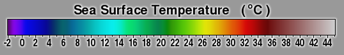
The following images are yearly night time Sea Surface Temperature (SST) images of the southern North Sea, from January 2005 to January 2012 taken by the AquaMODIS satellite. The images span the waters off Denmark Germany and the Netherlands
 The purpose of gathering, then enlarging the images by 2,000 percent, is to determine whether waters within and surrounding the Alpha Ventus ocean windfarm off the German coast showed any visible difference in local sea surface temperature, at the pixel level. The Alpha Ventus Windfarm consists of 12 five megawatt wind turbines 45 kilometers off the German coastal barrier island of Borkum. The windfarm went operational in the Autumn of 2009. Note that there is a fair amount of mixikng in shallow water envikronments, which may well mask any themal variation from upwelling, if any. Please take a look and contact us with your observations, and suggestions. Ocean windpower extraction will be coming to the Gulf of Maine, it is important to understand what impacts if any ocean windfarms can have on water column structure, as predicted and modeled by Norwegian govt meteorologist Goran Brostrom