Search

Showing posts with label 1998. Show all posts

Apr 17, 2026

Bay history April 1998. BDN: CWP vs GAC Soiled Flats

Parts 1 and 2 two part series: "Soiled Flats" by  Bangor Daily News reporter Wyatt Olson 4/6/98  Pt 1:  He accompanies us as bay fisherman Herbert Hoche, joined Peter McFarland  and myself  as we probe probe the tainted mud  below the abandoned acid plant and its eroding waste-filled shore.  Then, two two days later: emergency cleanup!

Soiled Flats Pt 1 4/6/98 "Volunteers wonder where the clams have gone."     Page 1   Page 2                                                                           


\


"Soiled Flats Part 2   The Clean Up "Oily Muck Vacuumed in Searsport."


Dec 24, 2024

GAC Chemical Links by Year 1998 - 2024

 GAC Chemical video and image links by Year  1998 - 2024

                                                1998 

Video 1998

MP4s  

GAC_1998_60min_pt1_12min.mp4

GAC_1998%20coast.mp4

GAC_1998_waste_coast_examined.mp4

GAC_1998%20coast.mp4

GAC_1998/gac_1998_cleanup_1.mpg

GAC_1998_waste_coast_examined.mp4


AVIs 

  GAC 1998_a_022098_waste_erosion_b_040798_cleanup.avi    (700mb)

GAC_vid_1998 2 parts: _A_022098_waste_erosion_B_040798_cleanup (AVI)


Images 1998

JPEGS

GAC 1998_acidplant_superphosphate_plant.jpg

GAC 1998_031698_hist_pt1.jpg  

 gac_1998_031698_hist_pt2.jpg

GAC_1998_cleanup_republican journal_070198_mcarpenter.jpg

GAC_1998_derelict_acid_plant_tank_from_flats.jpg

GAC_1998_filled_shore_below_factory_elevated_pipeline

gac_1998_flats_alumwastes_under_red_surface_layer

GAC 1998_flats_tarpaper_from_superphosphate_plant.

GAC 1998_flats_wastes_flocculants

GAC 1998 superphophate plant (derelict)_

 GAC 1998  superphosphate_plant. closed 1998.jpg

GAC 1998_superphosphate_plant_elevated_pipeline

gac_1998_acidplant_superphosphate_plant.jpg

gac_1998_cleanup_repjournal 070198_murray_carpenter.jpg

1998_video_stills/gac_1998_derelict_acid_plant_tank_from_flats.jpg

1998_video_stills/gac_1998_filled_shore_below_factory_elevated_pipeline.jpg

1998_video_stills/gac_1998_flats_alumwastes_under%20_red_surface_layer.jpg

gac_1998_flats_tarpaper_from_superphosphate_plant.jpg

gac_1998_flats_wastes_flocculants.jpg

gac_1998_superphosphate_plant.jpg

gac_1998_superphosphate_plant_elevated_pipeline.jpg

https://www.penbay.org/baytowns/searsport/gac_1998

https://www.penbay.org/av/gac_1998


February


March 

gac_dep_031698_history.jpg

gac_dep_031798_deltachem_phtest_060684.jpg

DEP Notice of Violation

gac_032798_dep_nova/gac_nova_dep_032798a.html

gac_032798_dep_nova

gac_nova_dep_032798a.jpg

gac_nova_dep_032798a.jpg

gac_nova_dep_032798a_small.jpg

gac_nova_dep_032898b.html

gac_nova_dep_032898b.jpg

gac_nova_dep_032898b.jpg

gac_nova_dep_032898b_small.jpg

gac_nova_resp_042098_pg1.html

gac_nova_resp_042098_pg1.jpg

gac_nova_resp_042098_pg1.jpg

gac_nova_resp_042098_pg1_small.jpg

ac_nova_resp_042098_pg2.html

gac_nova_resp_042098_pg2.jpg

gac_nova_resp_042098_pg2.jpg

gac_nova_resp_042098_pg2_small.jpg

gac_nova_resp_042098_pg3.html

gac_nova_resp_042098_pg3.jpg

/gac_nova_resp_042098_pg3.jpg

gac_nova_resp_041998_pg3_small.jpg

gac_nova resp 042098_reply to MDEP re NOVA 


PenBay Archive/CWP_1995 1998_GAC_oil


northern_chemical 1998_ Quonset fertilizer plant 


--------------------------------------------------------------------------------------------------

JPEGs

1999

1999_111599_epa_devillars_leaves_legacy.jpg


2000


2001

*  gac_2015_vrap_012215_no_action_assurance.pdf


2002 


Kidder Point 2002 derelict fertilizer plant.jpg


2003


2004


2005


2006


2007


2008


2009


2010


2011


2012

https://www.penbay.net/waste/gac/gac_101512_images_sent_dep/


2013

https://www.penbay.net/waste/lf_050113_gac_leachate_intertidal.jpg

https://www.penbay.net/waste/lf_050113_gac_leacheate.jpg

https://www.penbay.net/waste/lf_050113_gac_leacheate_sm.jpg

https://www.penbay.net/waste/gac/gac_071613_searsport_plboard_intro_ronhuber15min15sec.mp3

https://www.penbay.net/waste/gac/gac_101512_images_sent_dep/

2014


2015

https://penbay.org/gac/vrap/searsport%20gac%20vrap%20naa%20ltr%20012215.pdf

gac_2015_town_letter_vrap_022615.pdf

2016


2017


2018


2019


2020


2021


2022


2023


2024


Jun 3, 2023

1998 video investigation of Stockton Harbor's Kidder Point waste & pollution sites. Index

1998 video investigation & cleanup  of Stockton Harbor's Kidder Point waste & pollution sites.    Index and video 

Download this video  2hrs, 20minutes long   https://penbay.org/baytowns/searsport/gac_1998/gac_1998_a_022098_waste_erosion_b_040798_cleanup.avi   (may take 45 mins to download)

PART 1.  52min 32sec  February 20 1998 investigation of wastefilled  shore and intertidal mud 55 Minutes Penobscot Bay Watch site investigation. Will Neils, videographer.     NOTEPart 1 starts after 53 seconds of blank

PART 2   1hr 20min   April 7m, 1998  We discover waste problems in an outfall and a nearby seawater  intake out take pipeline bldg.  DEP orders Clean Harbors to clean it up   We witness that and chat wiith various officials       


PART 1 

START AT 53sec  Driving to Searsport

55sec  Panorama show of Stockton Harbor - no condos on Cape Jellison.

2:18  More panoramas of the facility   One notes the large wooden quonset structures

2:52 Closer in to old acid and superphosphate plant

4:00  Layered filled area near base of point on east side. Notes how far along bank the wooden fill corrals  extend (all the way to in front of the acid plant)

4:55 closer up up water dripping against exposed fill 

5:50  Closeup of another nearby dripping waste slump. 

6:50  Eroding slope  below the acid plant itself.

7:32 Slope 

8:11 osprey...Flats at the tip of the point. Old wooden  superphosphate plant quonset

9:41 outfall piles 

10:17 view to abandoned pumphouse outfall & oily sump. Aerial photos of illegal discharge

11:33 closeup of old superphosphate  wooden plant.  Elevated insulated pipelines from offshore point

12:30 Wooden chimney structure. Scan of the wooden structure then to shore below with artificial filled shoreline

13:22 Closeup eroding pipeline to old pumphouse, then filled shoreline from there to cistern full of oily waste.  We go and examine it.

14:01 Cistern waterfilled. See  top of outfall pipe into the cistern. Probe cistern catch basin: full of oily goo. 

15:53  Old electric junk including transformer View out to rail line with landfill beyond track  Scan around back of existing working plant  and to old superphosphate plant 

17:00 scan superphosphate plant

17:20 Approach old pumphouse

17:55  Down stairs to floor with hatches to bay    Examine hatches and outfall pipes

19:19 Examine oil spigot allowing oil to be discharged into bay .

20:51  Climb out of pumphouse

21:46. Examine a test well near abandoned superphosphate plant

22:51  Observe gust of black smoke from a facility

23: 10  View from the GAC landfill

24:13 View from top of landfill

25:44 Sulfuric acid tank warnings

26:25  Railside acid warnings. walk toward acid plant and superphosphate plant.

PART 2  March 5.  TIDAL FLATS adjacent to Kidder's Point   

27:55   March 5th GAC tidal flats exploration

28:07 Herb Hoche digs test squares,   Dead clams

29:03 Ron discusses clam mystery with Stockton Harbor background

30:29  Herb Hoche digs another site

32:45 Another dig

35:18 Another dig

38:35 Another sample "much closer to the plant"

39:44 Hoche discovers buried tarpaper from roof  of old wooden factory 

43:37  Another dig.  4527   "Our braintrust goes to work."  observes Will Neils.

45:54  Another dig  4944 note dig is in flow of waste

50:21 Examining  discolored mud, with flocculants on top. Hoche  digs, reveals multicolored layers of intertidal mud.  The adjoining shore where a broad reddish band of  leachate is seeping along a layer of clay downslope to upwell there the intertidal gravel and sand meet the mudflats ..  Hoche dabs the flocculants at several places along the red leachate 

52:40 Hoche  clamdigging in the discolored area Red layer, then an alum silver layer. then another  red Examine the mud there for signs of life; none.

54:05 Closeup of contaminated mud

54:20  Camera investigates the land adjacent to the acid plant

54:53 Top of  ditch running tainted water to the har4bor 

Part 3

56:24 At the old pumphouse again. The Cleanup crew is there at work on cistern

58:28 Ron sums up situation

59:40 Hoche examines seaweed in driftwood

60:03  Cleanup workers. Viewed from the beach - private property rights.   Pans down to  brook adjacent to site.  Herb Hoche  rinses hands in the stream.

63:00  DEP staffer Clarissa Trasko brings straw to below cistern  Goes uphill returns below discusses plan The big suction hose. more A DEP oilspill guy shows up we chat a bit.

71:30 Ron chats with  DEP official Clarissa Trasko at base of cistern.

76:00 2 Coast Guardsmen  arrive  discusses issue with Ron Huber He thanks them for convincing  the company to clean this up  talk ends at 83min

83:00  Suction hose underway

87:00 Officials congregate to watch from front of cistern

88:00 Suction starts up again.

88:38  Surface water removed by suction revealing the massive amount of oily goo there. 

1:29:50  cleanup guy gets suitedup. 

1:31 cleanup guy continues 

1:32 test samples collected, snuck away by company official 

1:33 View into cistern

1:35:45 View of cistern with cleaner guy inside

1:36  See outfall choked with waste 

1:36:50 Guy in protective suit in front end of cistern

1:42:10  See old junk boards that were burried in the muck.  he scrapes muck off them

1:47 Protective suit climbs out. A lengthy cleaning process for suit removal finally  removes his bootcovers, bags it all up and leaves

1:53 Inside of outfall half full 

1:54 Huber reviews the situation

PART 4

1:55:13   BACK TO PUMPHOUSE

1:56 Funky water alongside rail line. 

1:58:40 along rail line

2:00 Return to cleaned up cistern new wooden front, sheeny water...

2:02  Huber grabs muck sample

2:03:55 brook that goes to bay near the cistern b probed with a stick

2:04:40  Approach pumphouse 

2:05:30  Oil dump barrel is gone. Floor cleaned up. The oily glove still there.

2:08 Old lagoon alongside rail line

2:09 Panorama shot

2:11 Clean Harbors pumptruck

2:11:51  Steam cranes at Searsport  Clean Harbors is there, too  

END


Sep 1, 2020

Maine Coast Eco-history 1998 Dennys River


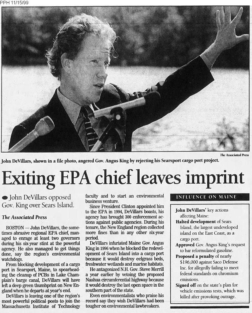
Maine Coast  Eco-history 1998. The below BDN article by reporter Mary Ann Clancy describes how   Maine Governor Angus King in being opposed as he tries to implement state wild salmon conserving alternative to federal  Endangered listing  of Atlantic salmon.
At issue: stakeholder Denny's River Watershed Council opposes state  setting up fishtraps called weirs to capture all upmigrating salmon, allow culling of aquaculture escapees, counting/ releasing wild fish. Problem: concentrates the salmon schools into single location- much more available to seals & 2-leggers at both ends of the weirs)

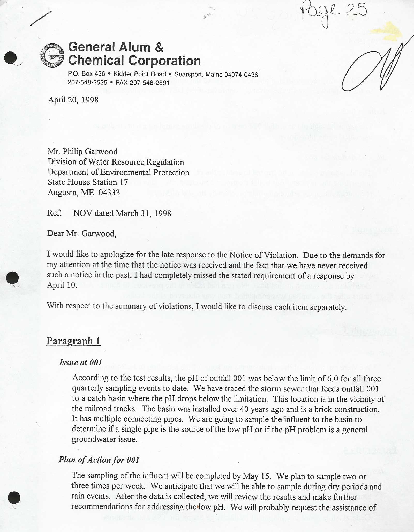
The Bangor Daily News    Thursday, August 6, 1998

Dennys River Watershed council says salmon face predators at proposed  weir site
By Mary Anne Clancy, Of the NEWS Staff --
Map Source _USFWS and NOAA

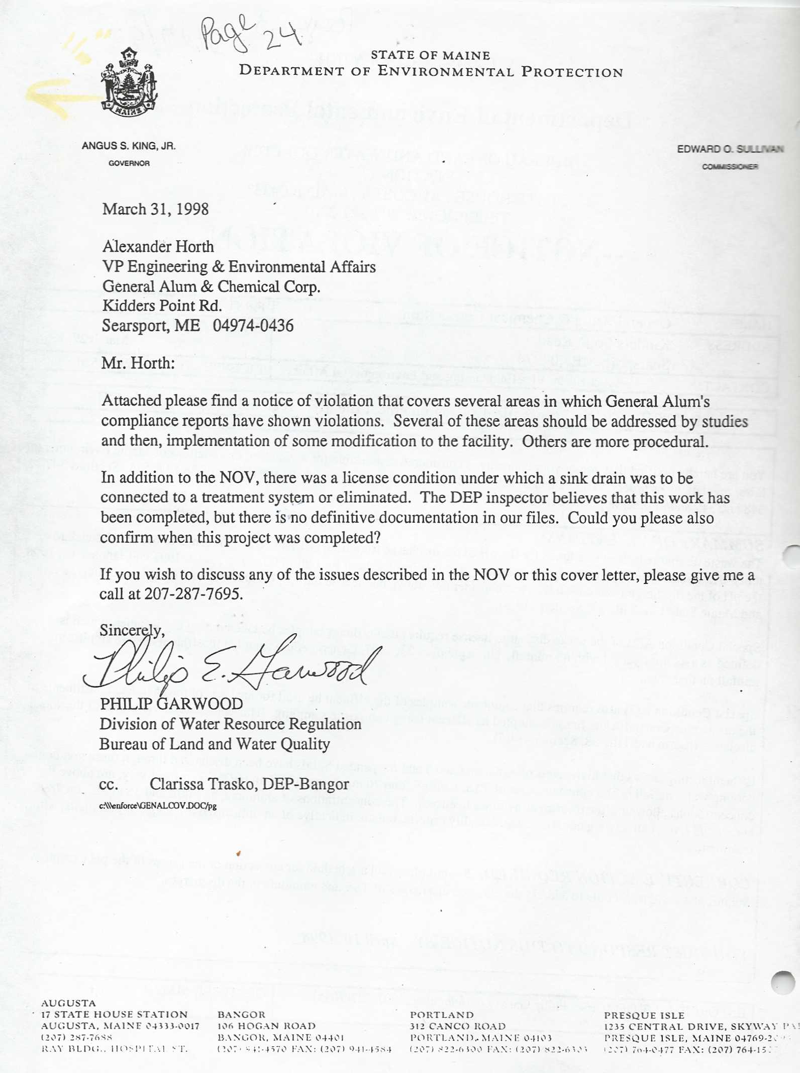
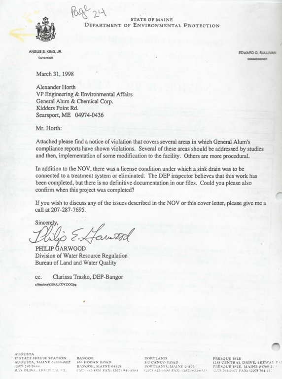
DENNYSVILLE - Maine's federally mandated state plan to protect Atlantic salmon took a
blow from within this week when a local watershed council opposed state placement
of a fish weir on the Dennys River.

The weir, designed to keep farmed salmon from
entering the river while allowing wild salmon to swim upstream to spawn, is a
critical part of Maine's Atlantic Salmon Conservation Plan.

The state adopted the
plan earlier this year to prevent a federal
listing of the Atlantic salmon as threatened
under the Endangered Species Act.


The Dennys River Watershed Council, which voted to oppose the weir this week, has no
authority to prevent it. But the local opposition comes as state officials begin the
first major salmon protection project amid expectations of a lawsuit that could call the
state plan into question.

The threat of a lawsuit was heightened last week when a federal court ordered the
National Marine Fisheries Service to designate coho salmon on the Oregon coast
as threatened under the Endangered Species Act. The court order stemmed from a
lawsuit by environmentalists and fishing groups in the Northwest who challenged
the validity of a largely voluntary state plan to protect the salmon. The court ruled that
NMFS could not accept the Oregon plan as a substitute for strong federal action. Some say
the ruling portends a similar lawsuit against Maine's plan.

Bill Nichols, chairman of the Maine Atlantic Salmon Authority, said the Dennys River
weir is an essential part of the Maine plan. For that reason, the salmon authority will
proceed with plans for the $250,000 weir, he said.

''I feel badly because we'd like to operate with community approval, but we're also
under pressure because the weirs are required under the Maine Atlantic
Conservation Plan,'' Nichols said. ''One way or another, there will be a weir there and
the only question is who will build it - the state or the federal government.''

Bill Robinson, chairman of the Dennys River Watershed Council, said his group supports
the state plan and knows that weirs are critical, but believes the location on the
Dennys River that the salmon authority has chosen is ''all wrong.'' The salmon authority
wants to put the weir at the site of an old mill pond at the mouth of the river and close
to the tidewaters of Cobscook Bay, Robinson said.

Salmon that don't swim into the weir esigned to channel them upriver quickly -
and many salmon won't enter a weir - either will be forced out to Cobscook Bay and
devoured by seals or will linger near the Edmunds bridge and be targets for anyone
who wants to take them, Robinson said.

The Dennys is one of seven Maine rivers that federal fishery agencies believe are home to
the last wild runs of Atlantic salmon in the United States. Earlier this year, Maine
adopted a salmon protection plan for those rivers as an alternative to a federal proposal
to designate the salmon as threatened under the Endangered Species Act. The
seven rivers are the Dennys, East Machias, Machias, Pleasant and Narraguagus in
Washington County and the Sheepscot and Ducktrap farther south in Maine.

Local watershed councils for each of the seven rivers also are part of the state
conservation plan. Members of the councils are to include all stakeholders in the
watershed, including major landowners, state and federal agencies, municipal
officials and businesses. The councils will identify and protect against threats to water
quality and salmon habitat within the rivers, according to the state plan.

At a meeting to adopt bylaws Monday, the Dennys River Watershed Council
unanimously opposed the weir site as its first official action, Robinson said. In addition to
expressing concerns about seals and human predators, the 15 people at the meeting
identified several other reasons for their opposition in a news release issued Tuesday.

The group said the weir would interfere with the scenic view of the lower Dennys
River. Construction of the weir would disturb sediments and logs on the river bottom,
possibly damaging downstream tidal clam flats, the council said. The release also stated
there had been no environmental impact statement.

Nichols said he agrees that seals could pose a problem, but that is something the salmon
authority will have to address through other measures.

The V-shaped weir is designed to guide fish swimming upstream into a trap. The trap
will be checked daily to allow wild salmon to swim freely upriver to spawn, and to remove
any aquaculture salmon from the river.

Weirs are a key part of the state plan for the Dennys, East Machias, Pleasant and
Narraguagus rivers because the rivers are close to salmon aquaculture operations on
the Washington County coast. The weirs also will be used to count the number of salmon
returning to the river, and to collect brood stock that will produce wild salmon for
future river stocking.

According to federal and state officials, aquaculture salmon that escape from their
sea pens pose several threats to wild salmon. The farmed salmon can expose the wild
salmon to diseases and parasites. The aquaculture fish can interbreed with the
wild salmon or the farmed fish could lay their eggs on top of the wild salmon eggs,
smothering them and reducing survival rates.

Nichols said the weirs should pose no threat o clam flats because the salmon authority
will use coffer dams to contain sediment during construction. The state wanted to
construct the weir on the site of a previous fence weir on land owned by the Dennys
River Salmon Club, but the club refused to grant the salmon authority access rights for
more than one year at a time, Nichols said.

 Since the new weir will cost $250,000 and is epected to be in place for 10 years, the
state could not agree with that arrangement, he said.

Nichols said the U.S. Fish and Wildlife Service has given Maine $1 million and instructed
the state to install the weirs. The money will pay for weirs on the Dennys, East Machias
and Pleasant rivers, and the Machias River weir will be put on hold, he said. The salmon
authority will install a temporary fence weir at the site this fall and will install the more
permanent V-shaped weir next spring, he said.

Henry Nichols, coordinator of the Maine Atlantic Salmon Conservation Plan and no
relation to Bill Nichols, said the job of the watershed councils is habitat protection, not
fish management. The state plan delegates fish management responsibility to the
Atlantic Salmon Authority, Nichols said.

''Obviously, we'd like to be partners in all aspects of this effort, but not putting in that
weir will cetainly jeopardize the whole state plan,'' he said.


1998, Bangor Daily News