Search

Showing posts sorted by relevance for query breakwater. Sort by date Show all posts

Aug 24, 2012

Camden Harbor breakwater study? Corps says, let's start

ACOE says: "[Camden] requested construction of breakwaters across the outer harbor to further protect the harbor from wave action and storms."
According to reporter Christine Parrish of the Free Press, the Army Corps of Engineers(ACOE) announced in its June 30 2012 Update Report for Maine that it will undertake a study and will begin "by gathering economic data from the commercial fishing fleet along with completing a depth survey in the vicinity of the proposed breakwater locations."

Below Parrish'[s article see the ACOE announcement

by Christine Parrish, Feature Writer, Free Press
In the 1960s Camden started discussing having the U.S. Army Corps of Engineers do a study to see if building a breakwater across the outer harbor would help protect the harbor from wave action and storms.


On January 26, 2007, the town submitted a request to the Corps; the Corps acted on it this June, by announcing in its Update Report for Maine that it will undertake a study and will begin "by gathering economic data from the commercial fishing fleet along with completing a depth survey in the vicinity of the proposed breakwater locations." By the time that announcement came out, the town had pretty much forgotten its request for a breakwater feasibility study, but Town Manager Pat Finnigan tracked back and found the 2007 letter and then got in touch with the Corps. The study, says Finnigan, is just the first step in a very lengthy process.

The Army Corps is not usually known for speed. In 2000, the Maine Department of Transportation asked the Corps to study deepening the 35-foot shipping channel at Mack Point in Searsport. The Corps completed a draft feasibility report this year that included project costs, economic benefits and environmental assessment, and it plans to hold a public review of the study sometime during the last three months of this year.

By contrast, a private business request for an Army Corps permit was relatively expeditious: DCP Midstream LLC was granted an Army Corps permit to pursue building a large propane storage tank at Mack Point less than a year after submitting an application.

End of FP article

------------------
Army Corps of Engineers, Update Report for Maine, June 30, 2012
CAMDEN HARBOR, CAMDEN (1st Congressional District) 
"The Camden Board of Selectmen requested the New England District
initiate a study under Section 107 of the River and Harbor Act of 1960 to determine the feasibility of implementing a navigation improvement project for Camden Harbor.

"Currently the Camden Harbor contains a Federal navigation project consisting of an inner and outer anchorage. The town requested construction of breakwaters across the outer harbor to further protect the harbor from wave action and storms.
This improvement potentially would provide further protection of harbor anchorages and shore facilities and allow for expansion of commercial activities. 

"During the initial phases of this investigation, economic data will be gathered from the commercial fishing fleet along with completing a depth survey in the vicinity of proposed breakwater locations."
End of update

Dec 17, 2021

Safe Harbors. DEP flawed review of Visual/Scenic Impacts

DEP's 

2. EXISTING SCENIC, AESTHETIC, RECREATIONAL OR NAVIGATIONAL USES:


The NRPA, in 38 M.R.S. § 480-D(1), requires the applicant to demonstrate that the
proposed project will not unreasonably interfere with existing scenic, aesthetic,
recreational and navigational uses.

A. Scenic and Aesthetic Uses: In accordance with Chapter 315, Assessing and
Mitigating Impacts to Scenic and Aesthetic Uses (06-096 C.M.R. ch. 315, effective June
29, 2003), the applicant submitted a copy of the Department's Visual Evaluation Field
Survey Checklist as Appendix A to the application along with a description of the
property and the proposed project.
The applicant also submitted several photographs of
the proposed project site and surroundings. Department staff visited the project site on
November 5, 2021.

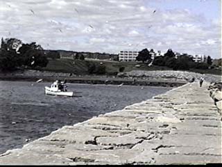
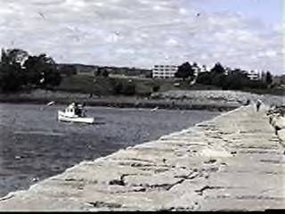
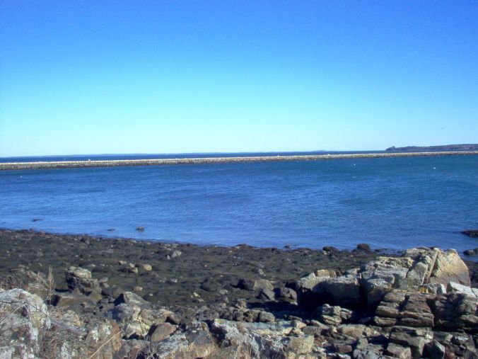
The proposed project is located in Rockland Harbor, which is a scenic resource visited by
the general public, in part, for the use, observation, enjoyment and appreciation of its
natural and cultural visual qualities. The project site is located adjacent to Sandy Beach
(also known as South End Beach), a 200-foot-long municipal beach. The project parcel
contains a paved walkway that is part of the Harbor Walk, a system of paths on multiple
public and privately-owned, waterfront properties that connects several public spaces and
viewpoints along the shoreline including Sandy Beach, Harbor Park, and Buoy Park, all
of which are located within 0.2 miles of the project site, and all of which meet the
Chapter 315 definition of a scenic resource of local significance. The project site is
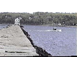
located approximately 1.35 miles from the Breakwater and the Breakwater Lighthouse,
both of which are listed on the National Register of Historic Places as areas of local


L-20386-4P-P-N/L-20386-4E-Q-N 5 of 20


significance. The harbor is developed with two municipal piers, a coast guard station,
and numerous commercial piers and buildings, including the applicant’s existing pier,
which are visible from the scenic resources listed above.

To reduce the visibility of the proposed project from the harbor and nearby scenic
viewpoints, the applicant designed the expanded marina with materials similar to those of
other commercial piers in the immediate area. In response to public feedback during
project design, the applicant reduced the size of the proposed float system and redesigned
the layout to avoid vessels being berthed broadside to viewpoints to the west, including
Buoy Park, a municipal pier (the Public Landing), and the boardwalk portion of the
Harbor Walk. 

The applicant reduced the proposed landward extension of the fixed pier, eliminating a proposed vehicle and crane access platform for servicing boats. The applicant also eliminated the need for an additional timber wave fence to the east by designing the proposed floats of Dock A to be concrete-encased wave-attenuating floats.

In their comments, many of the interested persons expressed concern that the applicant
will revoke public access to the Harbor Walk on their property and that large vessels
berthed at the marina will block views of or from the scenic features listed above.

Herein, “large vessel” refers to a vessel greater than 70 feet in length. A subset of
commenters expressed concerns about light pollution at night and the visual impact of
tour buses, which could be chartered by marina patrons for transportation to nearby
points of interest, parked in the upland near Sandy Beach. A number of commenters also
raised concerns about noise from electric generators of vessels berthed at the expanded
marina.

The Department provided a consolidated list of these comments to the applicant and 
requested a response. In its response, the applicant stated that the portion of the Harbor
Walk on its property will remain open to the public, and that the applicant will work with
the City to create a formal agreement for continued public access to the walkway. The
applicant also responded that the proposed landward extension of the pier will be open to
the public, and that the existing gate on the pier will be moved seaward, such that the
proposed project will provide a 120-foot-long viewing platform open to the public, with
views to the east beyond the expanded marina.

The applicant stated that the size of the vessels that will use the expanded marina is 
expected to range from 20 feet to 200 feet long, but the majority of the vessels berthed at
the marina will continue to range from 30 to 60 feet long. The applicant stated that the
vertical height of most large vessels that may use the pier is approximately 25 feet above
the water, or 7.5 to 17.5 feet above the height of the existing fixed pier, depending on the
tide. The applicant noted that the proposed project is primarily for transient dockage,
defined as a stay no longer than 15 consecutive days, and that the average size vessel at
the marina during the summer of 2020 was approximately 56 feet long, and the average
stay of a vessel over 70 feet long was only 2.6 days. 

The proposed Dock C, located innermost in the harbor, will be dedicated to vessels approximately 30-40 feet in length, whereas large vessels will be located farther from the Harbor Walk at Docks A or B. The applicant noted that a similar version of Dock C was previously approved in Department
Order #L-20386-26-G-B/L-20386-4E-H-N, although it was not constructed, and that
previous approved versions of Dock A extended farther seaward than the proposed
project. The applicant pointed out that large vessels already use the harbor, and
submitted a photograph dated June 2019, of a 200-foot-long cruise ship berthed at the
Public Landing, facing broadside to Harbor Park. The applicant stated that currently,
cruise ships and other large vessels often anchor in the outer harbor, where they can block
views of many of the scenic features noted above, such as the Breakwater and
Breakwater Lighthouse, whereas vessels berthed at the expanded marina will have a more
limited visual impact, primarily only affecting views of existing developed areas in the
harbor such as other commercial marinas, the Municipal Fish Pier, and the Dragon
Cement pier. The applicant concluded that the proposed project would have minimal
impact on views of significant scenic features.

The applicant stated that the expansion will use lighting similar to that of the existing
pier, which consists of lighting of the dock walking surface and potentially low-voltage
lighting directed at the floats. The Department determined that this lighting is compatible
with the existing visual landscape of the harbor at night. The applicant stated that the
proposed dock systems will include electrical hook-ups for small and large vessels, and
therefore the proposed project will not result in additional noise from onboard generators.

The applicant further stated that accommodations for buses are not contemplated in this
application, and any upland alterations to accommodate buses would require review and
approval by the Department in a future application. The Department acknowledges that
buses could potentially use the existing parking lot and nearby side streets, if allowed by
local ordinance to do so. However, the Department determined that this activity is
ultimately outside the scope of the Department’s review.

In assessing the visual impact of the proposed project, the Department considered the
information in the NRPA application, the interested persons’ comments, the applicant’s
responses, observations by Department staff at the site visit, and other related materials
on file. Some commenters stated that the applicant should provide a visual assessment
report with photographic simulations or concept drawings; however, the Department
determined that the information in the permitting record is sufficient for the Department’s
review.

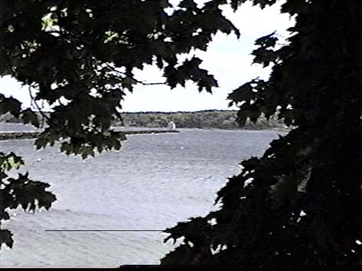
 During the review, the Department considered views from Rockland Harbor, the
Harbor Walk, Sandy Beach, Harbor Park, and Buoy Park, which are located in close
proximity to the project site and were of particular concern to the interested persons. 

The Department took into consideration the developed nature of Rockland Harbor, the size
and layout of the proposed marina expansion, and the existing viewsheds from the scenic
resources. 

The Department determined that the viewshed foreground of the Harbor Walk, Harbor Park, 
and Buoy Park are dominated by existing pier and float systems,
some of which currently berth large vessels during the summer. 

Sandy Beach, which faces northeast, has a viewshed of 120 degrees, bounded to the southeast by the Dragon Cement pier and bounded to the north by the applicant’s existing pier. 

Department staff  determined that the proposed expansion of the marina will affect approximately
17 degrees of the far west extent of the beach viewshed. The blocked views include other
commercial marinas to the north as well as a small portion of the harbor mooring field.
The proposed project will not interfere with views from the beach of the Breakwater,
Breakwater Lighthouse, islands, or other land masses to the east. 

Department staff also considered the potential view of the proposed project from the Breakwater and visited the landward end of the Breakwater on November 5, 2021; however, given the distance to the
project site and the highly developed nature of the harbor, the Department determined
that the proposed project will be consistent with the existing use of the harbor and will
result in little to no additional impact on views from the Breakwater.

The Department staff utilized the Department’s Visual Impact Assessment Matrix in its
evaluation of the proposed project. The Matrix is used to assess the visual impact
severity of a proposed project based on the distance and visibility of the project from a
natural landmark or other outstanding natural or cultural feature, State, National, or
locally-designated park or trail, and on the approximate number of people likely to view
the project from the resource or a public way per day. 

The severity rating is also based on the visual elements of landscape compatibility, scale 
contrast, and spatial dominance  as defined in Chapter 315, § 9. 

The Department determined that the visual impact of the  proposed project was acceptable with mitigation. As discussed above, the applicant  reduced the size and revised the layout of the proposed project considerably during the design phase, in response to concerns about visual impact. The applicant also proposes to create a public viewing platform and to maintain public access to the Harbor Walk over its private property. 

In light of these mitigation measures and based on the information  submitted in the application, information submitted during the review, the visual impact rating, and the site visit, the Department determined that the location and scale of the proposed activity is compatible with the existing visual quality and landscape characteristics found within the viewshed of the scenic resources in the project area.

Apr 18, 2007

MDEP nixes Samoset pier! Rockland Breakwater lobstering saved!


Rockland harbor lobstering, recreational fishing saved from resort pier plan.

Maine Department of Environmental Protection has rejected a proposal by Samorock to build a 550 foot pier in the scenic and fishery-rich waters adjacent to the Rockland Breakwater. The agency cited impacts to irreplaceable scenic resources, and noted the proposal's potential impacts to existing lobstering, recreational fishing and swimming uses of the site.

Maine DEP permit reviewer James Cassida wrote today: " The denial was issued by the Department on April 12th."

Rockland harbor lobsterman Arthur Johnson said "A lot of fishermen depend on Rockland harbor for their living. This is prime fishing area and next to a National Historic Landmark. This area should be protected forever from development of this type."

This marks the second time opponents of Samoset's pier plans have prevailed.
The city of Rockland's harbor commission has received a proposal to zone the harbor waters near the breakwater as a lobster fishing area. This would prevent future attempts at encroachment by marina sprawl wannabes.

Samoset has threatened to block public access to the historic breakwater if it didn't get its way. It is also seeking a zoning change from the city of Rockland allowing it to double the density of condominiums it has proposed to build near the breakwater.

Fat chance on either!

Jun 22, 2015

Public access in West Penobscot Bay for kayaking, pleasure boating & recreational fishing

A detailed list of public access ramps and docks of west Penobscot Bay. The list starts at the southwestern tip Saint George's Port Clyde and Tenants Harbor, then travels up to the mouth of the bay in Stockton Springs then upriver as far as Brewer and back down through Bucksport to East Penobscot Bay down to Stonington 
ST. GEORGE (PORT CLYDE / TENANTS HARBOR) 
Where Route 131 ends on the St. George peninsula, lies the Port Clyde Boat Ramp. This site is often crowded, especially when the ferry is in from Monhegan Island. Due to this congestion, parking is limited with no spaces reserved for boat trailers. A single cement boat ramp services the site and outhouses can be found at the ferry dock. Mackerel fishing from the town dock is a popular activity. 
Traveling north on Route 131 brings you to the village of Tenants Harbor. Along the shore on Commercial Street lies the Tenants Harbor Town Landing. This facility has a single cement boat ramp serviced by a float. Parking in the small lot is limited to 4 hours with no spaces for boat trailers.

SOUTH THOMASTON 
Access to the Weskeag River and its locally known striped bass fishery can be had via the South Thomaston Town Landing. This site, located off Route 73, Has a single blacktop boat ramp and adequate parking. Shore fishing here can be excellent, especially below the Route 73 bridge. 

ROCKLAND
Snow Marine Park, on Mechanic Street (off Route 73) in Rockland's southend, is the busiest boat ramp in the area. Two cement ramps, a float, an outhouse and large parking lot can be found here. Be prepared to pay a fee if you plan to use the ramp. 
One of the most visited attractions in this region is the Rockland Breakwater Light. This mile long breakwater, which is constructed of large granite blocks, is used by both sightseers (the light house at the end of the breakwater is the chief draw) and fishermen. The catch of shore anglers fishing off the breakwater consists mostly of mackerel and pollock, with the occasional striped bass, cunner and black sea bass mixed in. To get to this site, take Waldo Avenue off Route I at the north end of town and follow shore access signs until you arrive at the breakwater. Parking here is limited at best.
ROCKPORT
Rockport Marine Park lies at the foot of Rockport Harbor. The park has one black-top boat ramp, picnic tables, benches, out-houses and several floats. Parking for this facility is adequate with a few places set aside for boat trailers. A fee is charged to use the ramp. Fishing off the Harbor Master's dock is permitted, but fishing off several other docks in the park is not allowed.
LINCOLNVILLE In the town of Lincolnville, next to the Maine State Ferry Landing and along Route 1, is the Lincolnville Beach Boat Ramp. This is a town maintained boat ramp. A launching fee is charged for use of the blacktop ramp, there is limited free parking in the town lot and an outhouse is nearby. When the town lot is full, paying to park in the state owned lot is an option.

NORTHPORT (BAYSIDE) 
The Northport Public Landing (no boat ramp here) is a popular shore fishing location, especially when mackerel are running. To get here, take the Shore Road off Route 1 at Northport and follow signs to the landing. Parking here is adequate.
Another good shore fishing site is off the Bayside Town Dock in the village of Bayside. Follow the Shore Road north to Bayside Road to arrive at this location. Parking here is limited at best. 

BELFAST
The Belfast Town Landing is located in Belfast's waterfront district. An excellent extra-wide blacktop boat ramp, a large pier with floats, picnic tables, restroorns and large parking lot make this site user-friendly. A launching fee is charged to use the ramp and, due to boat traffic, shore fishing is not permitted off the dock. If you need assistance or information about the harbor, check in at the Harbor Master's office next to the ramp.
SEARSPORT
The Searsport Town Landing offers both shore fishing and a boat ramp. The town pier, float, a blacktop ramp, large parking lot, picnic tables and an outhouse can be found here. To locate the landing, look for a shore access sign on the right as you enter Searsport on Route 1 from the south. 
The Searsport Causeway connects Sears Island with the mainland. At this site parking is along a side road and shore fishing for stripers is possible off both sides of the causeway. To get to site, take a right onto Kidder Road when traveling north on Route 1 from Searsport.
STOCKTON SPRINGS 
Providing access to Stockton Springs Harbor is the Cape Docks Boat Ramp. To get to this site, follow Route 1 north into the town of Stockton Springs; proceed to the center of town and turn right onto Cape Road; follow Cape Road until making a right onto West Cape Road; then turn onto Dock Road and continue to the site. This town maintained facility has a single cement boat ramp that is in good condition. Parking is adequate. This site is mostly used by commercial fishermen and pleasure boat owners whose vessels are moored in the harbor. 
The Penobscot River has a history as one of Maine's most noted Atlantic salmon rivers and still supports several Atlantic salmon fishing clubs near its head-of-tide. Please note that fishing for Atlantic salmon in Maine requires an Atlantic salmon fishing stamp.  In addition, this is a hook and release fishery and only fly fishing gear can legally be used.  This paragraph has been superceded by Atlantic Salmon Commission Regulation which currently prohibits fishing for or taking Atlantic Salmon by any means from all Maine waters.
The Penobscot River is also experiencing growth in its striped bass fishery.  Several boat ramps on the lower reaches of the river provide good access to anglers with this species in mind.
HAMPDEN / FRANKFORT 
Two boat ramps provide access from the west side of the Penobscot River. The northern-most is Turtle Head Marina Boat Ramp off Route 1A in the town of Hampden. This ramp is in good condition and is serviced by a float. Parking is not a problem and restrooms are available. The second boat ramp is at Grist Mill Park, down river along Route 1A in the town of Frankfort. Available here are a paved boat ramp (not usable at low tide) and a large parking lot. 
EDDINGTON / BREWER / ORRINGTON / VERONA 
Anglers targeting Atlantic salmon may try their luck shore fishing at the Penobscot River's head-of-tide In Eddington. This paragraph has been superceded by Atlantic Salmon Commission Regulation which currently prohibits fishing for or taking Atlantic Salmon by any means from all Maine waters. From Brewer, follow Routes 9 and 178 east; turn left with Route 178 where Route 9 separates; immediately take Monument Drive; follow to the dirt and cobble access road on the left, just before Monument Drive reconnects with Route 178; walk or carefully drive to the shore. 
Located farther down river along the east bank are two more boat ramps. just off Routes 9 and 178 in Brewer is the North Main Street Boat Ramp with a large cement ramp (not usable at low tide) and large parking lot. 
Still farther down river is the South Orrington Boat Ramp (unusable at low tide) which has adequate parking. In the village of South Orrington, turn onto Blake Road from Route 15, cross Settlers Way Road and continue to the site. 
Verona Park boat ramp is at the lower reaches of the Penobscot River on Verona Island. This ramp is in good condition, there is plenty of parking and this site has the added benefit of being a fine shore fishing spot for stripers. To get to the park, take a left off Route I north prior to going over the bridge connecting Verona Island and Bucksport. 
PENOBSCOT
The South Penobscot Boat Ramp provides access to the Bagaduce River. To get to this site, follow Route I north out of Bucksport and connect with Route 175 south; just before entering the village of South Penobscot, look for the boat launch on the right. This town maintained cement ramp is in poor condition, is not usable around low tide and has limited parking. 
BLUE HILL 
Next to the Fire Station in the center of downtown Blue Hill lies the near Blue Hill Town Landing. This boat ramp provides access to Blue Hill Harbor and Blue Hill Bay. To get to the site, take Route 15 south off Route 1, just north of Bucksport. This site has a single cement boat ramp (unusable at low tide) serviced by a float. Parking for the site is adequate.  

May 21, 2016

Rockland's Harbor Mgmt Commission ponders state of breakwater, Harbor Park changes, more.

Listen at this link to the 55 minute long 5/17/16 Rockland Harbor Mgmt Commission meeting, in which commissioners and guests discuss those things that arise as spring finally arrives at this lobstering and tourism harbor, midway up the Maine coast. Topics ranged from state of the Rockland Breakwater, the fate of a long derelict ferryboat Monhegan anchored inside the breakwater, to reconfiguring Harbor Park and more. Speakers included Melissa Maker, Chair, Howie Edwards, Jr from the Rockland Port District, and lobsterman/workboater Richard Whitman. Rockland's new harbormaster Matt Ripley also spoke. Steve Betts of Bangor Daily News was there. Guests on the recording begin with Mike Grondin, Rockland tree warden and blind advocate of the Americans with Disability Act, and his concerns with the reduced accessibility of Rockland Breakwater, to disabled persons, due to gaps on the walking surface from shifting blocks of stone, and Ron Huber of Friends of Penobscot Bay. Later, a presentation by two engineer consultants from Milone & MacBroom on reconfiguring Harbor Park to improve public access and services where the blues festival and Maine lobster festival are held and cruise ship passengers come ashore . A good mix of people on and overseeing this important city commission.

Apr 7, 2007

Rockland Breakwater - DEP's draft denial and the final comment countdown!

It's only four days until the Maine DEP pounds the last nail into the coffee of the undead Samoset Pier. Help them swing the mallet by sending them your comments by close of business April 11, 2007. Email them to
James.Cassida(AT)maine.gov Use subject line: Samorock Pier application.

Below is an article by Melissa Waterman from the latest issue of Free Press Online summing up where things stand. Let Jim know that the pier would unacceptably and permanently degrade the water quality of the lobster-rich ecosystem of the northern end of Rockland Harbor.

DEP Issues Draft Denial of Samoset’s Pier Application
— by Melissa Waterman

Maine’s Department of Environmental Protection (DEP) has issued a preliminary denial of Samoset Resort’s application to construct a 12-foot-wide, 550-foot wooden pier, 50-foot ramp and 140-float system off its property in Rockland. According to Jim Cassida, Licensing Coordinator within the Bureau of Land and Water Quality in the Maine Department of Environmental Protection, “This is a draft denial, typical in larger projects. It allows all interested parties to review and comment. It’s the final opportunity for the applicant to overcome the objections contained in the draft denial.”

At the request of Samorock LLC, which owns the Samoset, DEP has extended the comment period on the draft to April 11. A final decision will not be issued until some time after that comment period is over. Appeals of final decisions go to the Board of Environmental Protection. “It is rare for an appeal to happen, but I fully expect an appeal in this case,” said Cassida.

The draft denial concluded that the proposed activity would “unreasonably interfere with existing scenic, aesthetic, recreational, and navigational uses,” and “would unreasonably harm a significant wildlife habitat.”

Following are excerpts from the findings in the preliminary denial:

“After reviewing the evidence in the record and viewing the project site, the Department finds that there is at least one practicable alternative to the project that would be less damaging to the environment. In particular, the applicant could use the existing marina facilities within Rockland Harbor as well as their existing ramp and float located on the breakwater. The applicant could provide a shuttle service to the marina facilities within Rockland Harbor and a harbor shuttle to transport residents and guests of the Samoset Resort to and from their boats located on a mooring within the established mooring area in Rockland Harbor.… Given that the construction of the proposed pier, ramp and float would result in a permanent loss of wetland area, as well as additional impacts to the wetland; and that the applicant has access to the water through existing marina facilities within close proximity to the development site, the Department finds that the applicant has not adequately demonstrated avoidance of impacts to the coastal wetland....

“IF&W [Inland Fisheries & Wildlife] stated that the construction of a pier, ramp and float system at this location will result in a loss of habitat functions and values. However, IF&W views that loss of habitat functions and values as not having an unreasonable impact to wildlife habitat.... The Maine Department of Marine Resources (DMR) commented that some loss of habitat functions and values may occur through displacement of the traditional lobster fishing area. However, DMR concluded that the proposal for a pier at this location would not have an unreasonable adverse impact on marine habitat.... Given that the construction of the proposed pier would result in a loss of habitat functions and value; and that the applicant has boating access to the water through its already existing structure and could have access through facilities within the Rockland anchorage, the Department finds that the applicant has not adequately demonstrated avoidance of impacts to marine wildlife and fisheries habitat.”

“…The Department has determined that two of the scenic vistas examined will be significantly adversely affected through construction of the proposed 740-foot pier, ramp and float. The scenic impact will occur to views from the Marie H. Reed Memorial Park, which serves as the primary access point for the public to the Rockland breakwater and the harbor/beach area at the base of the proposed pier....

“In consideration of these criteria the Department finds that the applicant has failed to demonstrate that the proposed pier, ramp and float will not dominate the landscape from the public viewpoint at both Marie H. Reed Park and the beach/harbor area at the base of the proposed pier structure. For the users of the coastal wetland, such as people walking along the intertidal area, and boaters, the pier would be a significant visual intrusion, traversing the entire width of the intertidal area. While persons walking the intertidal area would be able to pass beneath the dock, the dock would dominate the landscape and partially obstruct and/or fragment the view along the intertidal area towards the Rockland breakwater and across Rockland Harbor, significantly detracting from the visual and aesthetic quality of the resource and thereby interfering with this use of the coastal wetland. Additionally, the proposed pier, ramp and float will displace some traditional fishing area resulting in an impact on this traditional use and navigation within this portion of Rockland Harbor.”

Apr 9, 2025

Maine Dredge Team meeting outline notes and presentation April 7, 2025

 Maine Dredge Team Meeting  April 2025 agenda/outline

April 7, 2025

(See Army Corps of Engineers  April 2025 presentation (pdf)   (Searsport Harbor  is on page 12)

·        Projects completed 2024-2025

o   Isles of Shoals breakwater repairs – New Hampshire/Maine

§  Repair damage to 3 breakwaters

§  Construction began in June 2023, wrapped in November 2024

§  11,000 tons of new armor stone

§  Final cost around $10 million

o   Kennebec River (USN support-maintenance dredging)

§  Hoping to dredge every 2 years

§  40-60k cy material by hopper dredge; disposal at alternative Jack Knife Ledge Disposal Area

§  Completed in January 2025

§  No take of endangered species occurred

§  USN will be looking to expand the dredging footprint for the 2028 dredge adjacent to Bath Iron Works – still within the navigation channel

·        Sand suitable for placement in-river

·        Carlton Bridge to Doubling Point

·        USN coordinating NEPA and state reviews

o   May need additional consultation and/or permit updates to account for changes in footprint, increased dredging frequency, and use of alternate disposal area

o   Josias River, Ogunquit maintenance dredging

§  Mechanically dredged 10,300 cy of material; disposal at Isles of Shoals North Disposal Site

§  Completed in March

§  Had to leave some areas untouched due to presence of hard material (ledge)

§  Final survey on ehydro website

§  Last dredged 1994

·        Scheduled for award in 2025

o   Narraguagus River Maintenance Dredging

§  2024 contract solicitation cancelled – only one bidder, over budget

§  Re-advertised March 17, 2025 hoping to open bid April 17, 2025

§  Looking to do full FMP 150k cy of material; disposal at Douglas Isle Disposal Site

o   Bar Harbor breakwater repairs

§  2 repair areas between Bald Porcupine Island and Porcupine Dry Ledge and beyond Dry Ledge

§  WQC/CZM submitted for review in March

§  Goal to advertise contract in September 2025

§  Historical munitions testing in the area – USACE Baltimore District conducted a determination for probability of UXOs and found there would be low probability

o   Section 111 Shore Damage Mitigation Project – Camp Ellis, Saco

§  Phase I – 750 linear foot stone spur jetty and beach fill (~73k CY)

§  Phase 2 – sand nourishment

§  Authorizations under RHA CAP Section 111 at $12.5 million, WRDA 2007 to $27 million, WRDA 2022 to $45 million

§  WQC/CZM app for Phase I to be submitted spring 2025

§  Potential to use sand from Scarborough Beach depending on timing of projects – dredging not to impede navigability; looked for offshore borrow sources; potentially trucking material from upland quarry


 ·        Scheduled for 2026+

o   Isle au Haut Thoroughfare

§  In early planning phase

§  Mechanical dredging ~  2,400 cy – mostly sand, gravel, cobble – suitable for open water disposal; Flake Island disposal site under consideration

§  Current cost estimate ~$3M

§  Working with fishermen to ensure material is placed beneficially for habitat and fishing grounds

§  WQC and CZM applications anticipa
ted in summer 2025

§  2026 construction

o   Searsport Harbor maintenance dredging

§  Mechanical dredging of ~30k cy of material; not suitable for open water – potential to go in CAD cell – 2 sites under investigation; preferred CAD site outside channel near Mack Point

·        Legacy contamination with mercury from Holtrachem detected

§  WQC and CZM applications anticipated in summer 2025

o   Union River Maintenance Dredging           

§  Dredged in 2006-07 – encountered very fine wood pulp coming from upstream mills; material had been disposed at Tupper Ledge

·        Wood pulp does not want to stay in one place

§  Looking to re-align channel entrance – limits the amount of future material to be dredged; anchorage still needs to be dredged – material not suitable for aquatic disposal; identifying potential upland sites

§  USACE conducting due diligence; coordinating with USCG

§  Looking to reach decision point for path forward spring 2025

§  **Question for the group: has anyone seen successful aquatic disposal of wood pulp?

o   Georges River

§  Working to identify potential beneficial use placement sites, open water placement sites

§  ~24-25k cy material to go to 10 feet; town wants to go to 16 feet – increases dredge material to ~80k cy

§  Undertaking draft EA – late summer/early fall for public review and WQC/CZM for project to be conducted fall 2026 (assuming funding from congress)

§  Has gone through suitability determination to 10 feet – mostly silty with some fine grain sands; needs analysis to 16 feet – scheduled for this sampling season

·        Identified potential need in marshes close to Georges River – not sure how to get the material there

·        Any upland beneficial use needs to consider DEP criteria which may be slightly different from USACE


·     Marine Construction Industry Day on May 5 virtual event from 9am-12pm

o   Share with marine construction industry

o   Email nae-pn-nav@usace.army.mil to register and use the subject line “Marine Industry Day”

Portland CAD cell project

·        First CAD cell in the state of Maine – constructed January-March 2025

·        4 acre hole

·        Material from 3 projects dredged this season placed in the CAD cell – Maine State Pier, Ocean Gateway, Turner’s Island (interim cap)

·        ~40 total projects in Portland Harbor to use cell

·        Monitoring to determine if there should be changes to CAD cell management plan


enEnd